Automatic land and sea template segmentation method based on scanning line detection and application thereof

A technology of automatic segmentation and sea-land segmentation, applied in image analysis, image data processing, instruments, etc., can solve problems such as slow speed, easy holes, and low positioning accuracy of sea-land boundaries

Inactive Publication Date: 2014-09-24
UNIVERSITY OF CHINESE ACADEMY OF SCIENCES
View PDF3 Cites 12 Cited by
  • Summary
  • Abstract
  • Description
  • Claims
  • Application Information

AI Technical Summary

Problems solved by technology

When dealing with high-definition, complex background, and rich-detail remote sensing images, the automatic segmentation method of sea and land templates based on threshold segmentation has problems such as low positioning accuracy of sea and land boundaries, and holes are prone to appear in sea and land areas; while the automatic segmentation of sea and land templates based on texture segmentation The speed of texture feature extraction is very slow, and there are also problems of poor positioning accuracy, and holes are prone to appear in sea and land areas.
Therefore, for high-definition remote sensing images with complex sea and land backgrounds and rich details, the existing sea and land template segmentation methods based on threshold segmentation and texture segmentation often cannot obtain ideal results, and the existing detection methods cannot be quickly and accurately realized. Detection of sea surface targets in high-definition remote sensing images under complex sea and land backgrounds

Method used


Image

  • Automatic land and sea template segmentation method based on scanning line detection and application thereof
  • Automatic land and sea template segmentation method based on scanning line detection and application thereof
  • Automatic land and sea template segmentation method based on scanning line detection and application thereof

Examples


Embodiment Construction

[0013] The present invention will be described in detail below in conjunction with the accompanying drawings and embodiments.

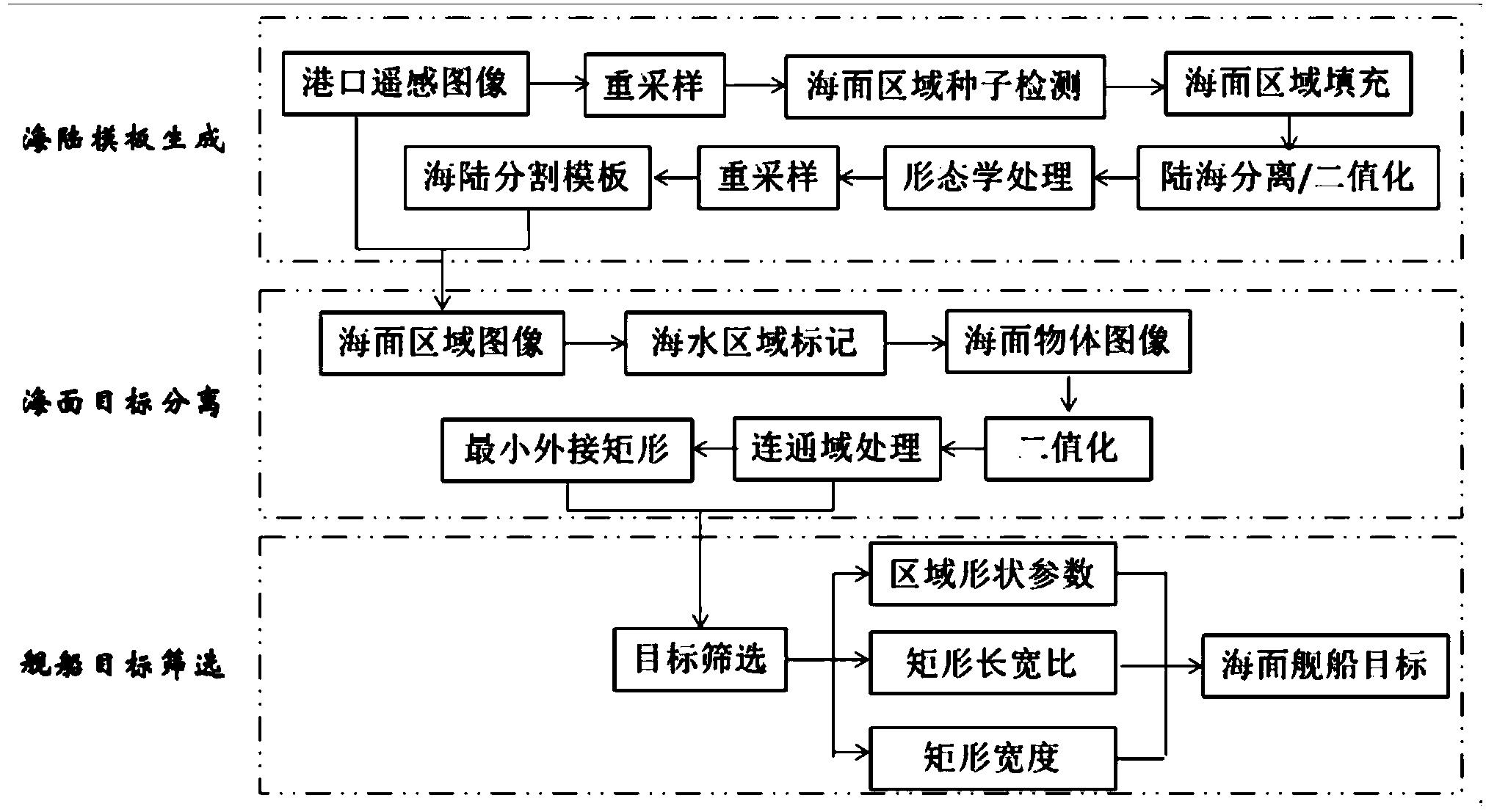
[0014] The sea and land template automatic segmentation method based on scan line detection of the present invention comprises the following steps (such as figure 1 shown in the first dotted box):

[0015] 1) Input the high-resolution visible light port remote sensing image to be detected (such as figure 2 Shown), carry out resampling processing according to the resampling processing method related to the pixel area in the prior art;

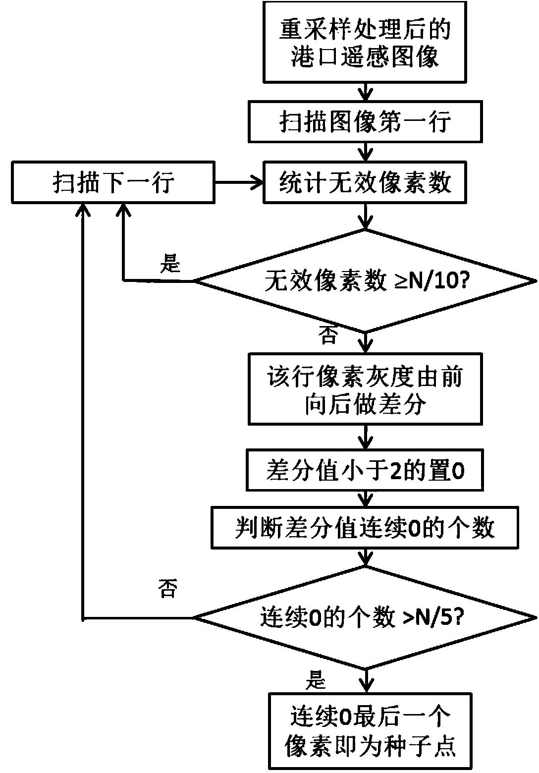
[0016] 2) For the port remote sensing image after resampling, use the sea surface region seed point detection method based on the scan line to detect the sea surface region seed point, the process is as follows (such as image 3 shown):

[0017] ①Scan the resampled port remote sensing image progressively from top to bottom, first scan the first line;

[0018] ② Determine the number of invalid pixels in the scanned ...


PUM


Abstract

The invention relates to an automatic land and sea template segmentation method based on scanning line detection and the application of the automatic land and sea template segmentation method. The automatic land and sea template segmentation method comprises the steps that (1) a high-resolution visible light port remote-sensing image to be detected is input and is re-sampled; (2) sea surface seed points are detected for the re-sampled port remote-sensing image; (3) among the obtained sea surface area seed points, all points with the gray values meeting following conditions in the adjacent area are searched for, wherein the conditions include that the difference between the pixel gray of the point and the gray of the adjacent seed point is not larger than 2, and the difference between the pixel gray of the point and the gray of the initial seed point is not larger than 8; the pixel points meeting the conditions are the sear surface area, and the other area is set as a land area; (4) the sea area and the land area are binarized; (5) morphological processing is carried out to obtain a land and sea segmentation template after the port remote-sensing image is re-sampled; (6) interpolation is carried out on the re-sampled land and sea segmentation template, and a land and sea template as big as the original remote-sensing image is obtained. The automatic land and sea template segmentation method based on scanning line detection and the application of the automatic land and sea template segmentation method can be widely applied to a sea surface target screening process of various civil and military fields.

Description

technical field [0001] The invention relates to an image detection method and its application, in particular to an automatic segmentation method of sea and land templates based on scanning line detection suitable for high-definition remote sensing images and its application. Background technique [0002] The existing sea surface target detection methods based on the automatic segmentation of sea and land templates generally adopt methods based on threshold segmentation or texture segmentation when realizing the separation of sea and land. When dealing with high-definition, complex background, and rich-detail remote sensing images, the automatic segmentation method of sea and land templates based on threshold segmentation has problems such as low positioning accuracy of sea and land boundaries, and holes are prone to appear in sea and land areas; while the automatic segmentation of sea and land templates based on texture segmentation The speed of texture feature extraction is...

Claims


Application Information

Patent Timeline
Patent Type & Authority Applications(China)
IPC IPC(8): G06T7/00
Inventor 吕科张毅飞潘卫国董继阳代双凤翟锐
Owner UNIVERSITY OF CHINESE ACADEMY OF SCIENCES
Why Eureka
Try Eureka