Satellite image based coastline automatic extraction and classification method

A classification method and automatic extraction technology, applied in the fields of instrument, character and pattern recognition, scene recognition, etc., can solve the problems of high labor and material resources, low efficiency, dangerous working environment, etc., and achieve automatic and rapid extraction and rich image color. Effect

Active Publication Date: 2016-07-06
THE CHINESE PEOPLES LIBERATION ARMY 92859 TROOPS
View PDF4 Cites 47 Cited by
  • Summary
  • Abstract
  • Description
  • Claims
  • Application Information

AI Technical Summary

Problems solved by technology

In addition, the operating environment of conventional measurement methods is relatively dangerous and requires a lot of manpower an

Method used


Image

  • Satellite image based coastline automatic extraction and classification method
  • Satellite image based coastline automatic extraction and classification method
  • Satellite image based coastline automatic extraction and classification method

Examples


Embodiment Construction

[0048] Embodiments of the present invention are described in further detail below in conjunction with the accompanying drawings:

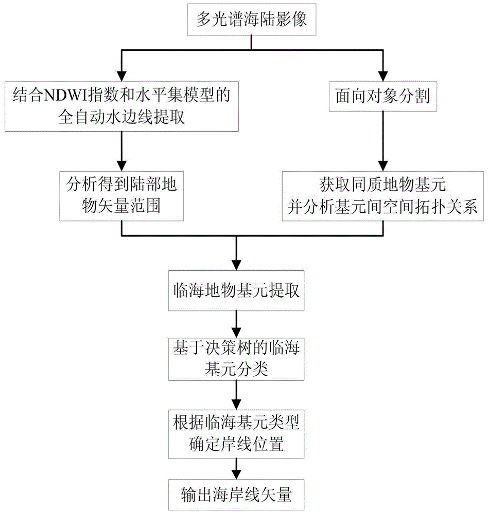
[0049] An automatic coastline extraction and classification method based on satellite images, such as figure 1 with figure 2 shown, including the following steps:

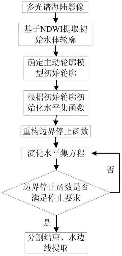
[0050] Step 1. After precise registration with the coastal zone area, such as image 3 The multispectral image shown is used as the data source, combined with the NDWI normalized water index and the level set model to obtain the precise outline of the water edge.

[0051] The waterside line refers to the instantaneous intersection line between the undulating sea surface and the land at a certain moment. Its extraction is of great significance for the subsequent study of coastline acquisition, intertidal zone classification and water depth inversion. The essence of waterside line extraction is the sea and land image. segmentation.

[0052] The concrete steps of described step 1 are:...


PUM


Abstract

The present invention relates to a satellite image based coastline automatic extraction and classification method. The method is characterized technically by comprising the following steps: step 1, using a multi-spectral image of a coastal zone after precise registration, and by combining a normalized difference water index (NDWI) and a level set model, obtaining a precise contour of a water boundary line; step 2, performing object-oriented segmentation on a land portion region, and extracting coastline coastal feature basic units by means of a spatial position topological relationship between the basic units; step 3, based on a decision tree, performing determination and classification on each coastline coastal feature basic unit; step 4, determining a coastline position according to a coastline interpretation rule; and step 5, on the basis of a result of the coastline position based on the multi-spectral image in the step 4 and property information, outputting a coastline vector based on a high-resolution panchromatic image. According to the method provided by the present invention, the coastline position can be rapidly, accurately and comprehensively surveyed and the change of the coastline position can be dynamically monitored.

Description

technical field [0001] The invention belongs to the technical field of marine surveying and remote sensing, and relates to various image processing and analysis technologies, in particular to an automatic coastline extraction and classification method based on satellite images. Background technique [0002] As the dividing line between ocean and land, the coastline is one of the most important topographical elements on land and sea maps, and is listed as one of the 27 most important surface features by the International Geographic Information Committee (IGDC). Coastline measurement is an important part of map surveying, hydrographic surveying, coastal zone survey, coastal evolution research, coast and sea area management, and is also an important basic geographic data. The coastlines mentioned in the present invention all refer to the National Standards of the People's Republic of China [such as "Oceanographic Terminology Marine Geology" (GB / T18190-2000) \ "Chinese Sea Chart...

Claims


Application Information

Patent Timeline
IPC IPC(8): G06K9/00G06K9/46G06K9/62
CPCG06V20/13G06V10/44G06F18/24
Inventor 闸旋滕惠忠申家双李海滨赵健叶秋果王耿峰
Owner THE CHINESE PEOPLES LIBERATION ARMY 92859 TROOPS
Why Eureka
Try Eureka