
Method and device for saving and loading map road shape point data

A shape point and data technology, applied in the field of navigation data system, can solve the problems of large hardware resources, slow display speed, and large data redundancy, and achieve the effect of avoiding data redundancy and high efficiency

Active Publication Date: 2014-12-24
SHANGHAI PATEO ELECTRONIC EQUIPMENT MANUFACTURING CO LTD
View PDF7 Cites 7 Cited by
  • Summary
  • Abstract
  • Description
  • Claims
  • Application Information

AI Technical Summary

Problems solved by technology

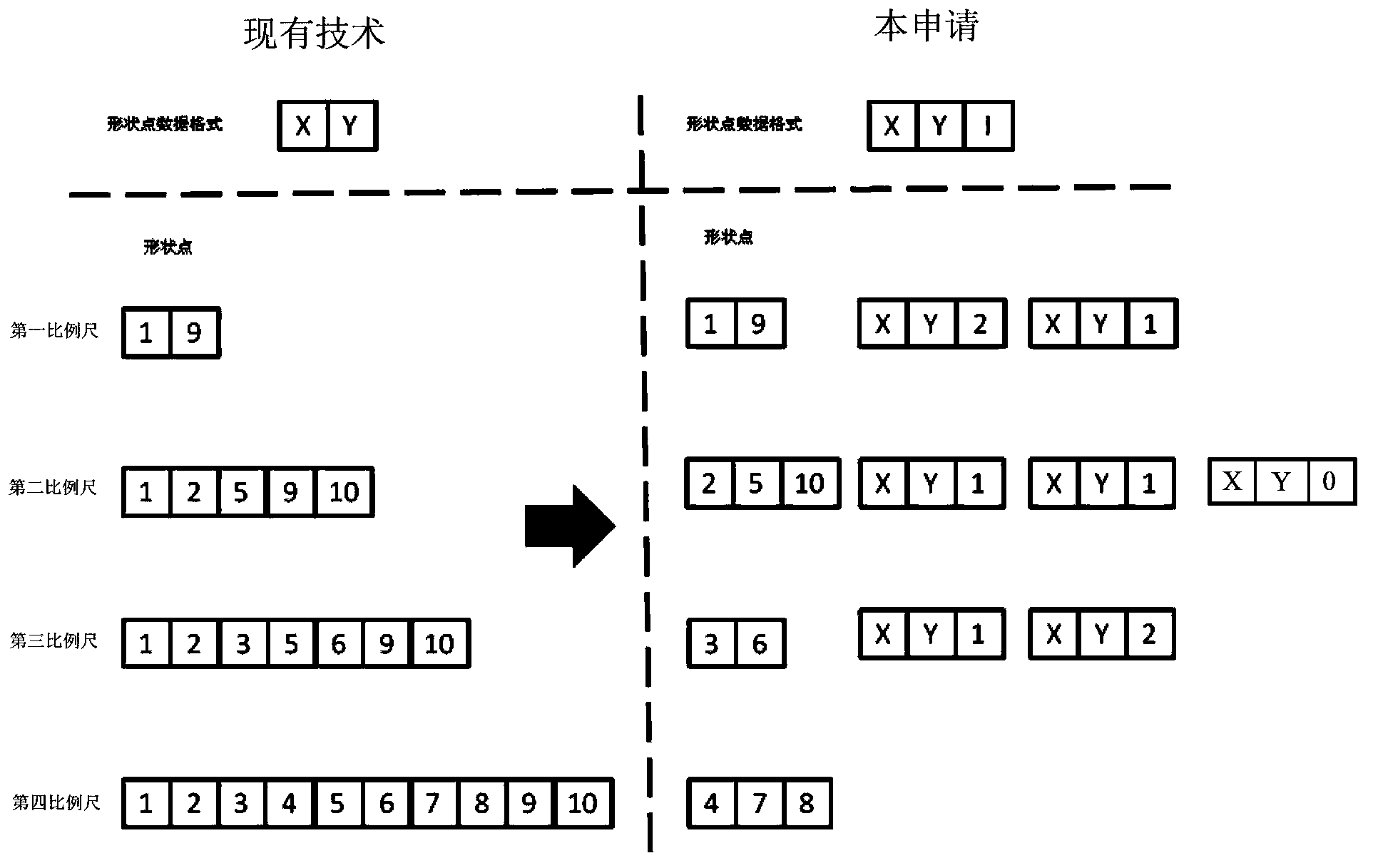
[0003] The above saving method leads to more data redundancy, and the same shape point data is repeatedly saved in multiple files; and when zooming under different scales, especially during frequent zooming operations, it is necessary to frequently release and read files , leading to the consumption of more hardware resources and slower display speed

Method used


Image

  • Method and device for saving and loading map road shape point data
  • Method and device for saving and loading map road shape point data
  • Method and device for saving and loading map road shape point data

Examples


Embodiment Construction

[0032] The present invention will be further described below in conjunction with specific embodiments and accompanying drawings, but the protection scope of the present invention should not be limited thereby.

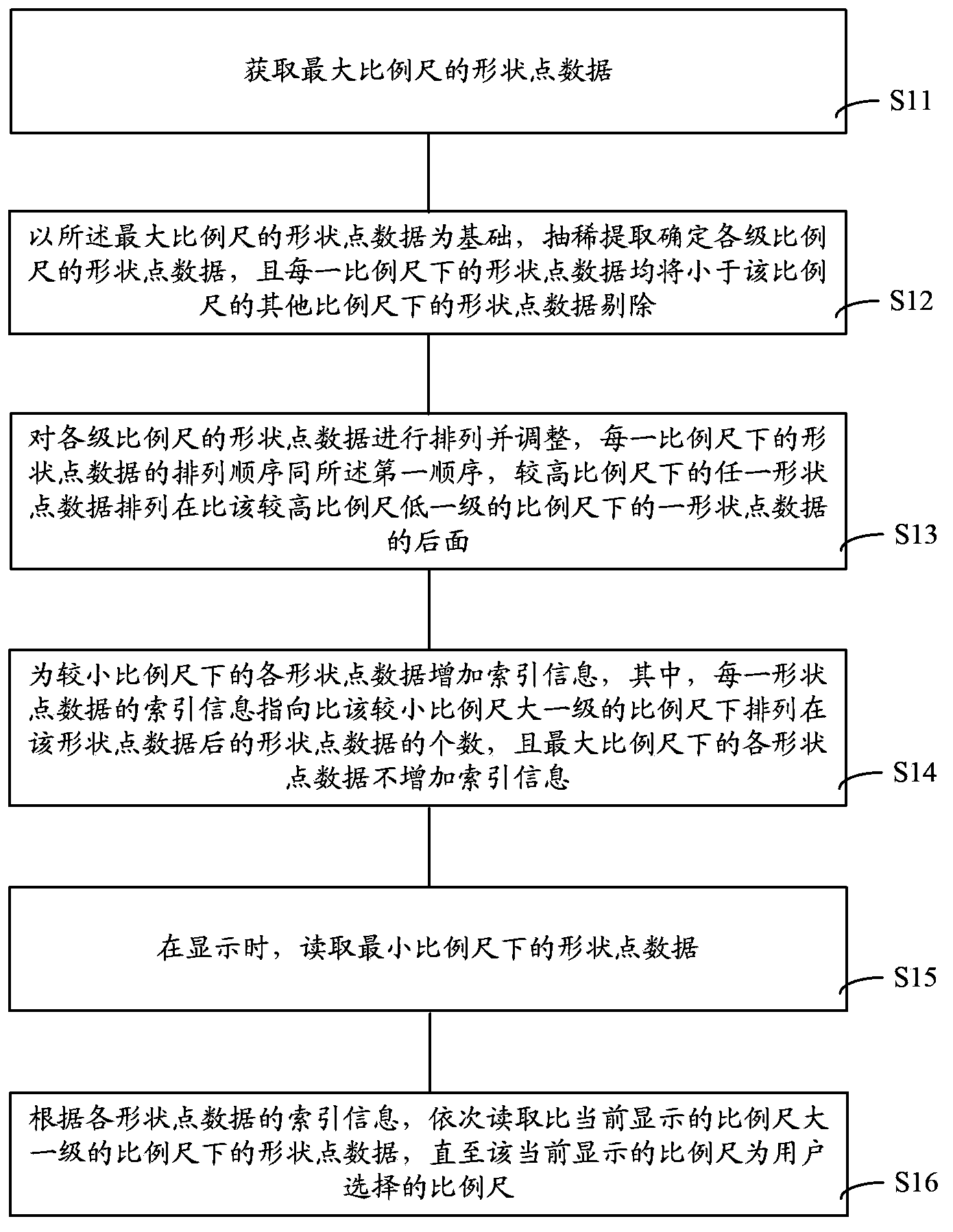
[0033] refer to figure 1 , the preservation and loading method of the map road shape point data of the present embodiment comprises the following steps:

[0034] Step S11, obtaining the shape point data of the largest scale, and the shape point data is arranged in the first order;

[0035] Step S12, based on the shape point data of the largest scale, extract and determine the shape point data of each scale, and the shape point data of each scale will be smaller than the shape point data of other scales. ;

[0036] Step S13, arrange and adjust the shape point data of each scale, the arrangement order of the shape point data under each scale is the same as the first order, and any shape point data under a higher scale is arranged at a higher Behind the point data of a...


PUM


Abstract

The invention provides a method and a device for saving and loading map road shape point data. The method includes: acquiring the shape point data with the largest measuring scale, and sorting the data according to a first order; determining the shape point data of each measuring scale level through vacuating extraction on the basis of the shape point data with the largest measuring scale, and removing the shape point data smaller than each measuring scale and under other measuring scales; arranging and adjusting the shape point data of each measuring scale level; adding index information to the shape point information under a smaller measuring scale, wherein the index information of each shape point datum points to the number of the shape point data arranged behind the shape point datum under a measuring scale one level larger than the smaller measuring scale, and no index information is added to the shape point data under the largest measuring scale. By the method, redundancy of the saved shape point data is avoided, and saving and loading efficiency are increased favorably.

Description

technical field [0001] The invention relates to navigation data system technology, in particular to a method and device for saving and loading map road shape point data. Background technique [0002] In the prior art, the preservation of road shape point data is based on the shape point data under the largest scale, and the shape point data under other scales are extracted according to the size of different scales. The shape point data under each scale are each represented by a The file is saved. [0003] The above saving method leads to more data redundancy, and the same shape point data is repeatedly saved in multiple files; and when zooming under different scales, especially during frequent zooming operations, it is necessary to frequently release and read files , leading to the consumption of more hardware resources and slower display speed. Contents of the invention [0004] The technical problem to be solved by the present invention is to provide a method and devic...

Claims


Application Information

Patent Timeline
IPC IPC(8): G06F17/30
CPCG06F16/2272G06F16/29
Inventor 莫铃
Owner SHANGHAI PATEO ELECTRONIC EQUIPMENT MANUFACTURING CO LTD
Learn More