

Mobile updating method for change pattern spots in land use status change survey
An update method and a technology of pattern spots, applied in the field of data processing, can solve the problems of reduced work efficiency, insufficient coordinate accuracy, and unequal coordinate points, and achieve the effects of improving work efficiency, saving time, and saving time and cost.
Active Publication Date: 2015-01-21
SOUTHEAST UNIV
View PDF2 Cites 24 Cited by
- Summary
- Abstract
- Description
- Claims
- Application Information
AI Technical Summary
Problems solved by technology
[0003] When updating the changed area data of the base map using the changed patches collected in the field, if there are problems such as incorrect coordinate points in the collected patches and insufficient coordinate accuracy, it will affect the accuracy of the updated base map data. At the same time, when checking the topology consistency of the updated data, there will be errors in the topological relationship. In this case, retesting and correction are required, which increases the workload of land use status change investigation and reduces work efficiency.
Method used
View moreImage
Smart ImageViewing Examples

Examples
Embodiment
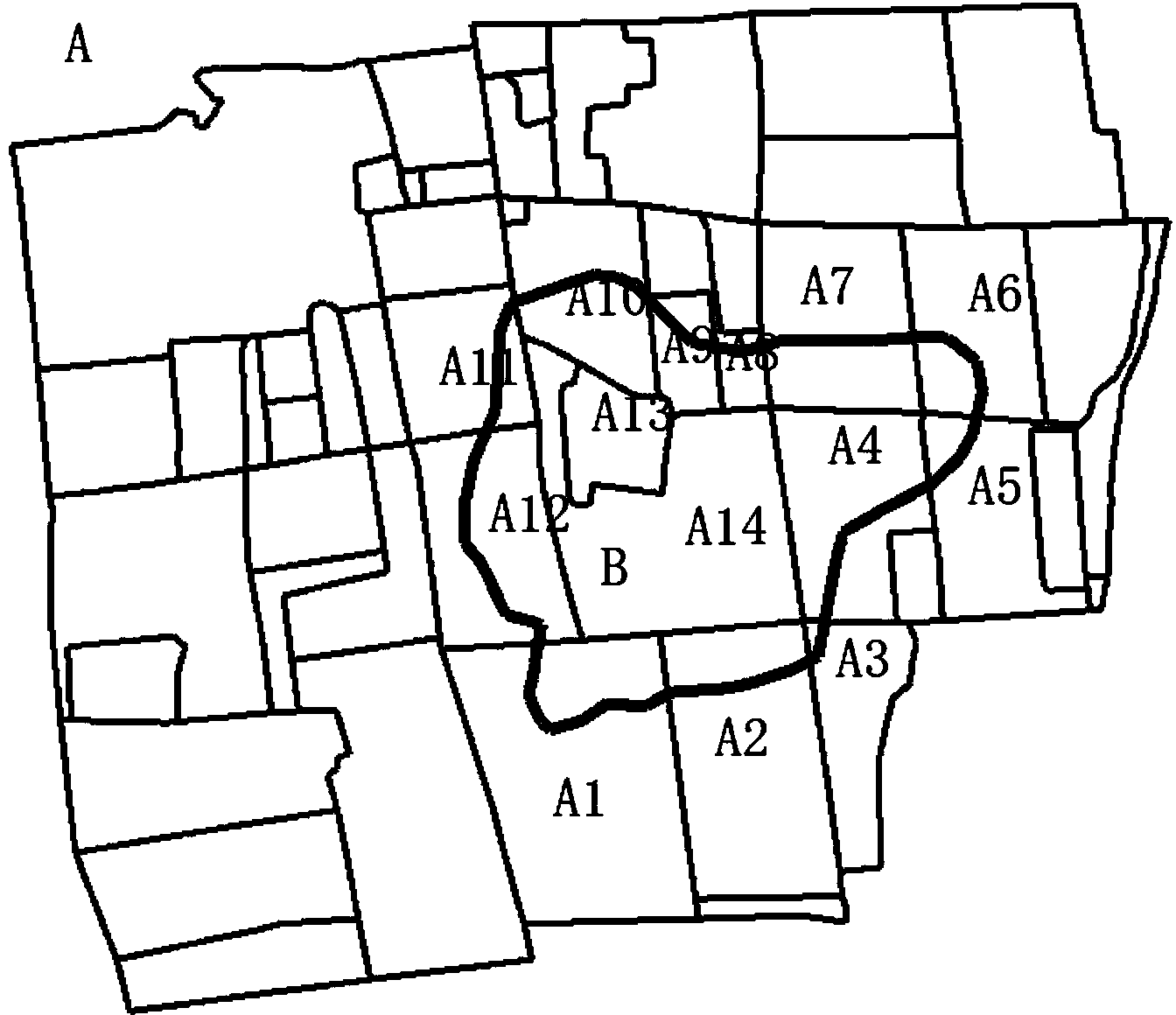
[0068] like Figure 5 As shown, taking the base map spots and changed map spots of a certain province, city and township as an example, using the present invention to perform an update operation on the mobile platform, the update results are as follows Image 6 shown. Depend on Figure 5 and Image 6 From the comparison, it can be seen that through the present invention, the update effect of the changed map can be obtained in real time, thereby judging in real time whether the changed map is collected accurately, and then obtaining an accurate changed map, which can finally reduce the workload of the land use status change investigation ,Improve work efficiency.
Login to View More PUM
 Abstract
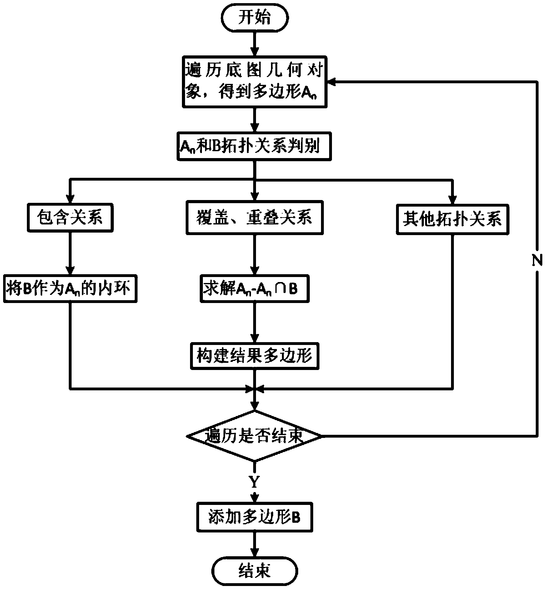
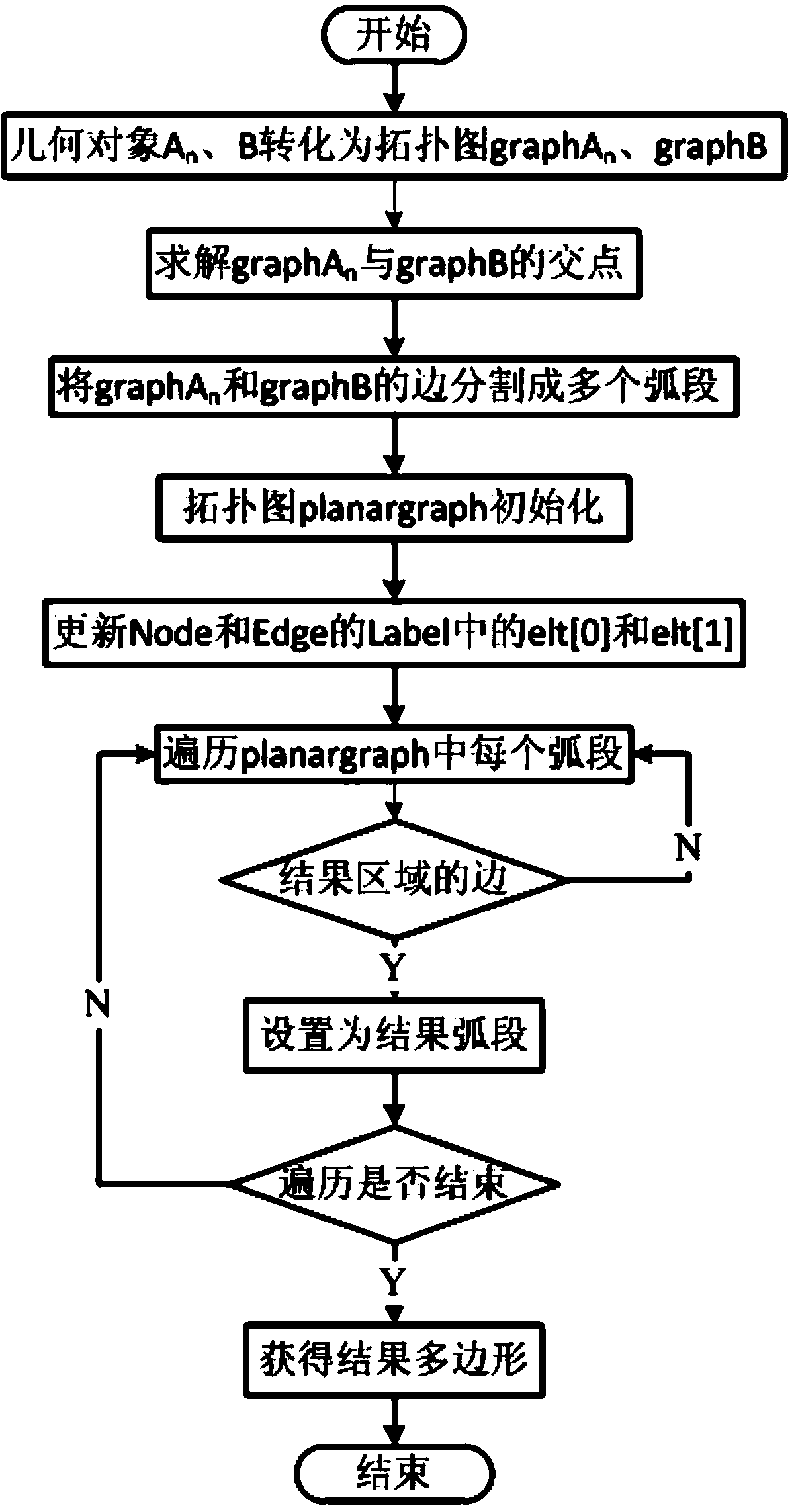
The invention discloses a mobile updating method for change pattern spots in land use status change survey. The mobile updating method is characterized by comprising the steps of orderly traversing geometric object elements from a base map pattern spot data set A according to the coordination information of updated patterns to obtain the changed geometric pattern spot information, next, judging the topological relation of two geometric objects according to the topological relation of the base map pattern spots An and the changed pattern spots B, and finally, updating the mobile changed pattern spots B into the base map pattern spot data set A, wherein the topological relation includes a disjoint relation, an inclusion relation and a coverage relation, an overlapping relation, an equivalence relation, an and included relation and a covered relation. The mobile updating method for change pattern spots in land use status change survey is capable of avoiding re-measurement of field data due to inaccurate change data, saving a certain time cost and improving the working efficiency.
Description
technical field [0001] The invention relates to a data processing method, in particular to a method for moving and updating changed map spots in the investigation of land use status change. Background technique [0002] The update method of space vector data mainly involves five steps: data acquisition; extraction and expression of change information; extraction of incremental information; update operation and update quality maintenance. The update process of map spot vector data is to use the remote sensing monitoring results of this year and the previous year's land survey database, combined with relevant survey data, use a third-party software platform to interpret and extract the change information of the whole land type to generate the vector of suspected changed map spots file; conduct field verification in the field, mainly use the data acquisition module through human-computer interaction, collect and change the graphic boundary, and determine the nature of the chang...
Claims
Login to View More Application Information
Patent Timeline
 IPC IPC(8): G06F17/30G06T7/60G06T7/00
Inventor王慧青崇素文王庆李玲
OwnerSOUTHEAST UNIV