Real-time Interaction Method and System of Geographical Information Service Based on Digital Television Network

A geographic information service and digital TV network technology, applied in the field of geographic information service applications, can solve problems such as poor real-time interactive experience, and achieve the effect of improving interactive experience

Inactive Publication Date: 2019-04-02
中测高科(北京)测绘工程技术有限责任公司
View PDF7 Cites 0 Cited by
  • Summary
  • Abstract
  • Description
  • Claims
  • Application Information

AI Technical Summary

Problems solved by technology

[0004] The present invention provides a method and system for real-time interaction of geographic information services based on a digital television network, and solves the technical problem in the prior art that the mode of IPTV is used to realize the real-time interactive experience of geographic information services.

Method used


Image

  • Real-time Interaction Method and System of Geographical Information Service Based on Digital Television Network
  • Real-time Interaction Method and System of Geographical Information Service Based on Digital Television Network
  • Real-time Interaction Method and System of Geographical Information Service Based on Digital Television Network

Examples


Embodiment Construction

[0022] In order to make the above objects, features and advantages of the present invention more comprehensible, the present invention will be further described in detail below in conjunction with the accompanying drawings and specific embodiments.

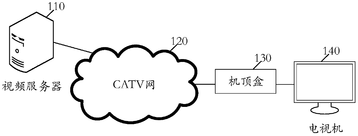
[0023] Such as figure 1 As shown, an application scenario diagram of a real-time interactive method for geographical information services based on a digital television network is provided in an embodiment of the present invention, including a video server 110, a CATV network (digital television network) 120, a set-top box 130, and a television set 140. The server 110 provides geographic information services to users, the digital TV network 120 is used to transmit digital TV signals, the set-top box 130 has a codec function and is a user access device of the digital TV network, and the TV 140 is used to display geographic information service images to users. The video server 110 is taken as an example below to introduce a real-time...


PUM


Abstract

The invention relates to the field of geographic information service application and discloses a digital TV network-based geographic information service real-time interaction method and a system thereof. The method comprises the steps of obtaining the uploaded data information, analyzing the data information to obtain an interaction instruction, obtaining a geographic information service interaction instruction according to the interaction instruction, matching the geographic information service interaction instruction, simulating a geographic information service event according to the matching information of the geographic information service interaction instruction so as to obtain the display image of the geographic information service event, and encoding the display image and sending the display image to a digital TV set-top box to display the geographic information service event. The digital TV network-based geographic information service real-time interaction function is realized, the audio-video decoding capability of the digital TV set-top box is utilized thoroughly, and the interaction experience of the geographic information service is enhanced.

Description

technical field [0001] The invention relates to the application field of geographical information services, in particular to a digital television network-based real-time interactive method and system for geographical information services. Background technique [0002] Digital television is a television system or television equipment that uses digital signals. The specific transmission process is: the image and sound signals sent by the TV station are digitally compressed and modulated to form a digital TV signal, which is transmitted by satellite, terrestrial wireless broadcast or cable cable, and received by the digital TV. Demodulation and decoding restore the original image and audio. Digital signals provide unprecedented development space for radio and television because of their high compression and interactive features. Television services are undergoing a leap from traditional "watching TV" to "using TV". , which provides an unprecedented opportunity for the developm...

Claims


Application Information

Patent Timeline
Patent Type & Authority Patents(China)
IPC IPC(8): H04N21/258H04N21/654H04N21/472
CPCH04N21/25841H04N21/47205H04N21/654
Inventor 范荣双张建廷荆凯旋杨宗富曹萌景新超
Owner 中测高科(北京)测绘工程技术有限责任公司
Why Eureka
Try Eureka