A method and system for absorbing multimedia information by track points

A technology of multimedia information and track points, applied in multimedia data retrieval, multimedia data browsing/visualization, geographic information database, etc., can solve the problems of inability to organize and display

Active Publication Date: 2019-09-20
方正国际软件(北京)有限公司 +1
View PDF5 Cites 0 Cited by
  • Summary
  • Abstract
  • Description
  • Claims
  • Application Information

AI Technical Summary

Problems solved by technology

However, with the rapid improvement of the functions of positioning terminals (GPS terminal, Beidou terminal, mobile phone, IPad, etc.), users not only want to know the trajectory information of the target itself, but also have a demand: what happened around the target trajectory point (such as : Intersection camera video, high-speed checkpoint image, surrounding case information, call recording, Beidou SMS, alarm information, etc.)? A large amount of rich multimedia event information is related to track points, but cannot be organized and displayed in a scientific and orderly manner

Method used


Image

  • A method and system for absorbing multimedia information by track points
  • A method and system for absorbing multimedia information by track points
  • A method and system for absorbing multimedia information by track points

Examples


Embodiment Construction

[0037] The present invention will be further described below in conjunction with the accompanying drawings and specific embodiments.
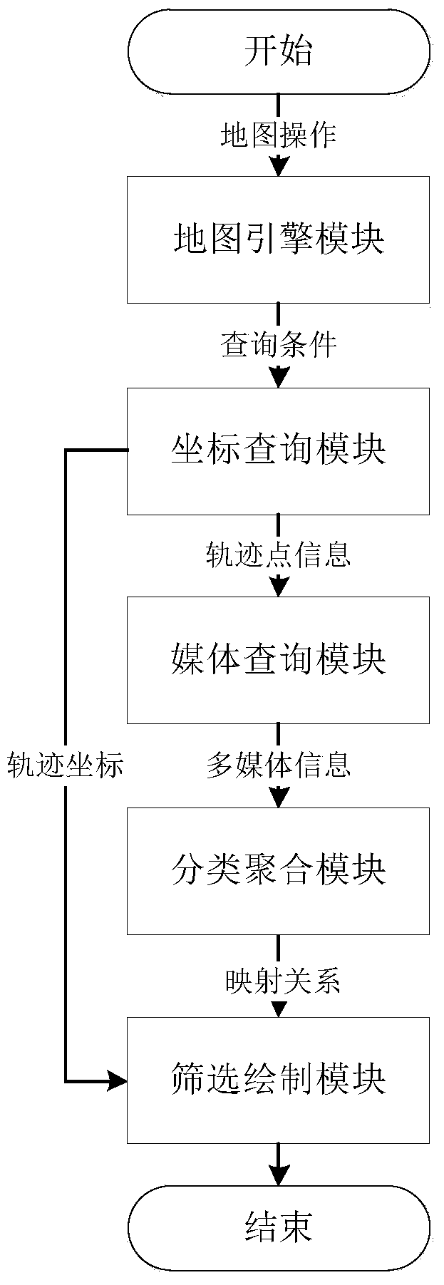
[0038] Main idea of ​​the present invention is:

[0039] 1) Dynamically extract multimedia information around track points through the "geographical axis";

[0040] 2) Filter multimedia information through the "classification and aggregation module";

[0041] 3) Through the change of "geographical axis" and "time axis", it is displayed in linkage with the track points.

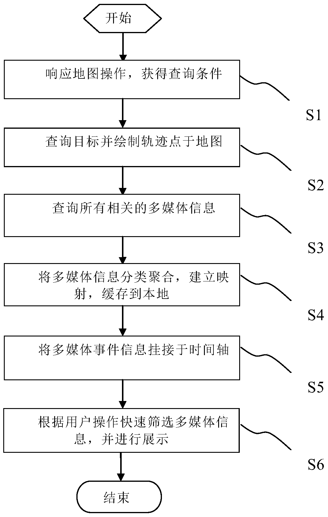
[0042] Such as figure 1 As shown, a method for absorbing multimedia information at track points includes the following steps:

[0043] S1, the first step is to respond to the map operation and obtain query conditions, the query conditions include one or more target IDs, geographical ranges, time ranges, etc.;

[0044] The above-mentioned response map operation only briefly describes the means of obtaining query conditions, which can be manually input specific target ID, geo...


PUM


Abstract

The invention relates to a method and system for adsorbing multimedia information through track points, and belongs to the technical field of computer geographical information systems. In an existing geographical information system, generally speaking, track point information can only show the movement attribute of a target. The method includes the following steps: 1, responding to a map operation to obtain query conditions; 2, querying all track points of the target according to the query conditions, and drawing a track on a map; 3, querying all the related multimedia information according to the coordinates and geographical radii of the track points; 4, classifying and aggregating the related multimedia information; 5, hooking the multimedia event information to a time axis according to the sequence of occurrence time. By adopting the method and system, the related information such as videos, voices, pictures and texts around the track points of the target can be conveniently and rapidly shown on the electronic map, and then information of the track points of the target can be closely and sequentially related to the multimedia information of events occurring around the track points of the target.

Description

technical field [0001] The invention relates to the technical field of computer geographic information systems, in particular to a method and system for absorbing multimedia information by track points. Background technique [0002] In the computer geographic information system, a common application is: draw the track points of the target movement on the electronic map, and present them to the user after connecting them with lines, and become the target track. [0003] In the existing geographic information system, track point information can generally only display the motion attributes of the target (position, speed, direction, elevation, etc.). However, with the rapid improvement of the functions of positioning terminals (GPS terminal, Beidou terminal, mobile phone, IPad, etc.), users not only want to know the trajectory information of the target itself, but also have a demand: what happened around the target trajectory point (such as : Intersection camera video, high-spe...

Claims


Application Information

Patent Timeline
Patent Type & Authority Patents(China)
IPC IPC(8): G06F16/29G06F16/487G06F16/44
Inventor 汪利宝徐晨曦甄冲程永辉周小良
Owner 方正国际软件(北京)有限公司
Why Eureka
Try Eureka