Fast on-line analysis processing method based on spatial position

A technology of on-line analysis and processing and spatial location, which is applied in the direction of electrical digital data processing, special data processing applications, instruments, etc., and can solve the problems of low flexibility in rapid statistical analysis, query, etc.

Active Publication Date: 2015-08-05
吉奥时空信息技术股份有限公司
View PDF4 Cites 8 Cited by
  • Summary
  • Abstract
  • Description
  • Claims
  • Application Information

AI Technical Summary

Problems solved by technology

[0009] The present invention mainly solves the technical problems existing in the prior art that it cannot support fast statistical analysis according to any spatial range and the query flexibility is low, and provides a fast online analysis and processing method based on spatial position
This method integrates quadtree modeling with the establishment of OLAP aggregation table, so as to solve the problem of OLAP fast query based on arbitrary spatial range

Method used


Image

  • Fast on-line analysis processing method based on spatial position
  • Fast on-line analysis processing method based on spatial position
  • Fast on-line analysis processing method based on spatial position

Examples


Embodiment

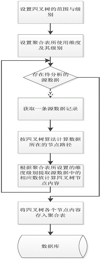
[0042] like figure 1As shown, the data preprocessing operation is required first, and the source data is aggregated according to the spatial dimension into the aggregate table data represented by the quadtree form. The aggregate table here is established to improve the query of a specific dimension level. What is the statistical data at the provincial level by year, when creating an aggregation table, only the dimensions of time and administrative division need to be retained, and only the aggregation calculation needs to be performed at the level of province and year. Similarly, if any range needs to be counted by year, then when creating an aggregate table, it is necessary to set the dimensions of the aggregate table to include spatial range and time, and select the level of the quadtree according to the accuracy of the range statistics.

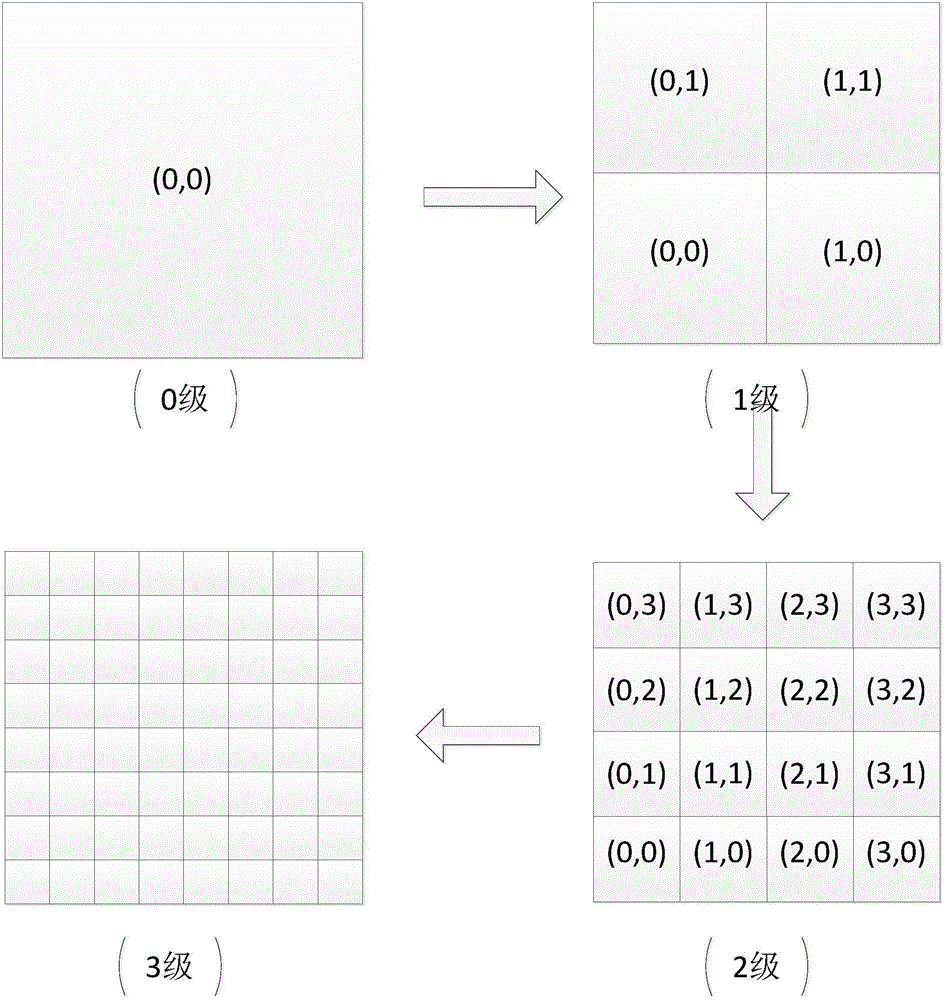
[0043] Here, the levels of the quadtree represent the spatial hierarchy of aggregations, such as figure 2 shown. At the very beginning...


PUM


Abstract

The invention relates to a fast on-line analysis processing method based on a spatial position, and belongs to the field of geographic information processing methods. The method comprises the following steps: aggregating source data as aggregation table data represented in a quad-tree manner according to spatial dimension; and determining a selection range selected by a user on a map while generating a report, aggregating light-weight aggregation data of each quad-tree node belonging to the selection range according to a query dimension selected by the user to obtain a query result. Therefore, the method disclosed by the invention has the following advantages of: 1, supporting the generation of the report at any aggregation dimension in any range by integrating with pre-statistics based on geographical coordinates; 2, satisfying two capacities of real-time administrative division and random range query under a big data condition so as to make up the disadvantage of the traditional administrative division query.

Description

technical field [0001] The invention relates to an on-line analysis and processing method, belonging to the field of geographic information processing methods, in particular to a fast on-line analysis and processing method based on spatial position. Background technique [0002] With the development and application of database technology, the amount of data stored in databases has transitioned from mega (M) bytes and gigabytes (G) bytes in the 1980s to terabytes (T) bytes and gigabytes (G) bytes now. At the same time, the query requirements of users are becoming more and more complex, which involves not only querying or manipulating one or several records in a relational table, but also performing data analysis on the data of tens of millions of records in multiple tables. Analysis and information synthesis. In this case, online analytical processing (OLAP) technology is usually used to support complex analytical operations, and complex query processing of large data volume...

Claims


Application Information

Patent Timeline
Patent Type & Authority Applications(China)
IPC IPC(8): G06F17/30
Inventor 张立刘琳周云陈彬吴杰贺楷锴张龙黄俊韬杨曦
Owner 吉奥时空信息技术股份有限公司
Why Eureka
Try Eureka