Navigation method, navigation system and corresponding mobile terminal

A navigation method and technology of a navigation system, applied in navigation, surveying and mapping, navigation, measuring devices, etc., can solve positioning and navigation problems, and achieve the effects of high positioning accuracy, accurate positioning, and low cost

Pending Publication Date: 2015-11-11
PHICOMM (SHANGHAI) CO LTD
View PDF15 Cites 6 Cited by
  • Summary
  • Abstract
  • Description
  • Claims
  • Application Information

AI Technical Summary

Problems solved by technology

[0006] In the existing positioning and navigation methods, they are usually aimed at outdoor positioning and navigation, and cannot perform more accurate positioning and navigation indoors and in places without known maps (such as shopping malls, parks, etc.)

Method used


Image

  • Navigation method, navigation system and corresponding mobile terminal
  • Navigation method, navigation system and corresponding mobile terminal

Examples


Embodiment Construction

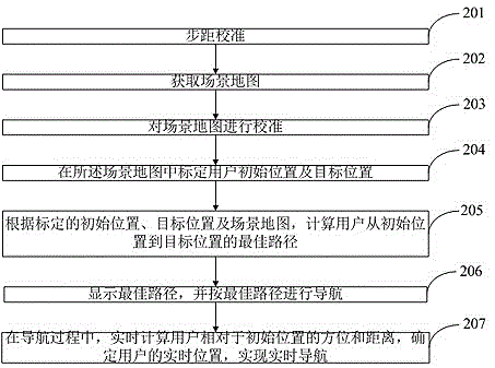
[0044] Hereinafter, in conjunction with the accompanying drawings, a preferred embodiment is described in detail to further illustrate the present invention.

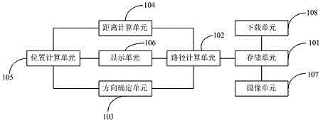
[0045] Such as figure 1 As shown, a navigation system installed on a mobile terminal, such as a mobile phone or a tablet computer, includes: a storage unit 101 for storing a scene map and the initial position, target position and selected position calibrated in the scene map; path calculation The unit 102 is connected to the storage unit 101 and is used to calculate the best path based on the initial position and the target position; the direction determining unit 103 is used to determine the direction the user moves; the distance calculation unit 104 is used to determine the distance traveled by the user The position calculation unit 105, respectively connected to the direction determination unit 103 and the distance calculation unit 104, is used to calculate the user's location in real time according to the information fe...


PUM


Abstract

The invention discloses a navigation method. The navigation method comprises the following steps: acquiring a scene map, calibrating the original position and target position of a user in the scene map; calculating the optimal path from the original position to the target position according to the calibrated original position, target position and scene map; displaying the optical path, and navigating according to the optimal path; and in the navigation process, calculating the direction and distance of the user away from the original position in real time, and determining the real-time position of the user so as to realize the real-time navigation. The invention also discloses a navigation system and a corresponding mobile terminal. The navigation system is suitable for navigation at indoor emporiums, conference and exhibition places, large park and the like; on the basis of the mobile terminal which is provided with a direction sensor and a camera, extra expenditure is not needed, the map is acquired by shooting, so that relatively accurate navigation can be realized, and further, the user cannot be puzzled by routes, and can reach the expected places.

Description

Technical field [0001] The present invention relates to the field of navigation technology, in particular to a navigation method, system and corresponding mobile terminal. Background technique [0002] Usually in large shopping malls, exhibitions and large parks, the route will be very complicated, some large shopping malls if unfamiliar people enter, usually get lost. However, the general navigation system in such places cannot make correct navigation due to reasons such as lack of map information, inability to receive signals, and insufficient positioning accuracy. [0003] At present, in mobile terminal applications, navigation functions are usually realized through GPS, AGPS, mobile phone base stations and other methods, and these methods require known map files and corresponding wireless signals to work, and these navigation methods are suitable for small areas In walking, the accuracy is usually not enough, and there will be large deviations. When users need to navigate ind...

Claims


Application Information

Patent Timeline
IPC IPC(8): G01C21/00
CPCG01C21/00
Inventor 夏惠斌
Owner PHICOMM (SHANGHAI) CO LTD
Why Eureka
Try Eureka