Supercharge Your Innovation With Domain-Expert AI Agents!

A Discrimination Method of Urban Road Traffic Status Based on Bus Vehicle GPS Data

A technology of GPS data and road traffic, which is applied in the traffic control system of road vehicles, traffic flow detection, traffic control system, etc., which can solve the problems of unstable detection data, large traffic data detection errors, and high economic costs, and improve urban Traffic management level, high prediction accuracy, and the effect of overcoming high economic costs

Active Publication Date: 2017-03-01
严格集团股份有限公司
View PDF5 Cites 0 Cited by
  • Summary
  • Abstract
  • Description
  • Claims
  • Application Information

AI Technical Summary

Problems solved by technology

[0004] The purpose of the present invention is to solve the problems of high technical and economic cost, large traffic data detection error and unstable detection data in the existing method, and propose a method for judging urban road traffic status based on bus-mounted GPS data

Method used


Image

  • A Discrimination Method of Urban Road Traffic Status Based on Bus Vehicle GPS Data
  • A Discrimination Method of Urban Road Traffic Status Based on Bus Vehicle GPS Data
  • A Discrimination Method of Urban Road Traffic Status Based on Bus Vehicle GPS Data

Examples


specific Embodiment approach 1

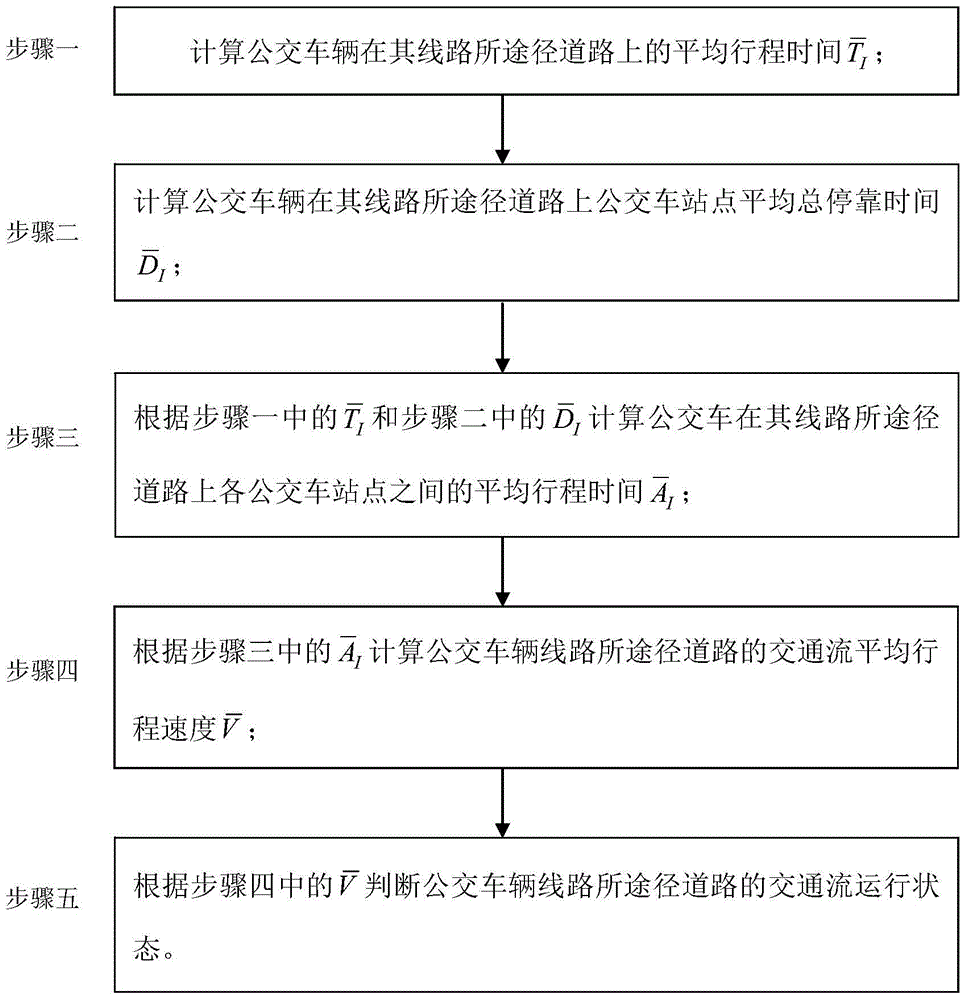
[0015] Specific implementation mode one: combine figure 1 and figure 2 Illustrate the present embodiment, a kind of urban road traffic state discrimination method based on bus-mounted GPS data, it is characterized in that, a kind of urban road traffic state discrimination method based on bus-mounted GPS data is specifically carried out in the following steps:

[0016] Step 1. Calculate the average travel time of the bus on the roads that its route passes

[0017] Step 2. Calculate the average total stop time of bus stops on the roads that buses pass through

[0018] Step 3, according to step 1 and the Calculate the average travel time between bus stops on the roads that a bus takes on its route

[0019] Step 4, according to the step 3 Calculate the average travel speed of the traffic flow on the roads that the bus routes pass

[0020] Step five, according to step four Judging the traffic flow operation status of the road that the bus line passes through.

specific Embodiment approach 2

[0021] Specific embodiment two, the difference between this embodiment and specific embodiment one is, in the described step one, calculate the average travel time of the public transport vehicle on the road where its route passes The specific process is:

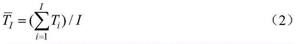
[0022] The average travel time T of the i-th bus on the road i for:

[0023] T i =t" i -t' i (1)

[0024] In the formula, T i The unit is seconds;

[0025] t' i is the moment when the i-th bus enters the road, in seconds;

[0026] t″ i is the moment when the i-th bus leaves the road, in seconds;

[0027] Assuming that within X minutes (X takes a value of 30 minutes), there are a total of I buses leaving the road on which their routes pass, and the average travel time of these I buses on the roads passing by their routes for:

[0028]

[0029] In the formula, The unit is seconds; the value range of i is 1≤i≤I, where I is a positive integer and i is a positive integer.

[0030] Other steps and parameters ...

specific Embodiment approach 3

[0031] The specific embodiment three, what this embodiment is different from the specific embodiment one or two is that in the step 2, calculate the average total stop time of the bus station at the bus station on the route route of the bus vehicle The specific process is:

[0032] Step 21. Determine the time d′ of the jth bus stop on the road where the i-th bus enters its route ij ; The specific process is:

[0033] The GPS device on the bus collects bus operation data at intervals of 1 second, including data such as latitude and longitude, speed, direction, and altitude, and uploads the data to the bus management center, which then matches the GPS data to the electronic road map; Bus i is within 10 meters from stop j, and d′ ij , d' ij +1, d' ij When the running speed at +2 time is less than or equal to 5km / h, define d' ij is the moment when bus i enters stop j, d′ ij , d' ij +1, d' ij The unit of +2 moment is seconds, i is a positive integer, and j is a positive in...


PUM


Abstract

The invention relates to a method for determining the urban road traffic state based bus-mounted GPS data and solves the problem that a conventional means is high in cost, great in traffic data detection error and unstable in detection data. The method includes a first step of calculating average travelling time Ti of a bus on the road of the bus route, a second step of calculating average stop times Di at the bus stations along the bus route, a third step of calculating the average travelling time between each two stops of the bus route according to the Ti obtained in the first step and the Di obtained in the second step, a fourth step of calculating the average traffic flow speed of the road according to the results got from the third step, and a fifth step of determining the traffic flow running state of the roads on the bus route according to the results got from the fourth step. The method is applicable to the urban traffic field.

Description

technical field [0001] The invention relates to a method for judging urban road traffic states based on GPS data on a bus. Background technique [0002] Urban road traffic state discrimination is an important basis for urban traffic management, and has a wide range of applications in urban traffic signal control, traffic flow guidance, and traffic information release. The existing urban road traffic state discrimination techniques can be divided into two categories. One is the discriminative method based on fixed detector data, which uses induction loop detectors and video detectors arranged on the road to obtain the running speed of motor vehicles, and then judges whether the traffic is in a smooth, generally congested or very congested state. The other is to use the vehicle-mounted GPS data of the taxi to obtain the running speed of the taxi, and then infer the running speed of the motor vehicle on the road, and then judge the traffic state. The first type of method need...

Claims


Application Information

Patent Timeline
Patent Type & Authority Patents(China)
IPC IPC(8): G08G1/01G08G1/052
Inventor 别一鸣李溪昂刘少韦华刘翰宁
Owner 严格集团股份有限公司
Features
  • R&D
  • Intellectual Property
  • Life Sciences
  • Materials
  • Tech Scout
  • Unparalleled Data Quality
  • Higher Quality Content
  • 60% Fewer Hallucinations
Learn More