VTS system radar return video display method based on geographic coordinate system

A geographic coordinate system and radar echo technology, applied in radio wave measurement systems, instruments, etc., can solve the problems of radar target mismatch, increase system overhead, and inability to use map data sets, and achieve the effect of ensuring consistency

Active Publication Date: 2015-12-30
THE 28TH RES INST OF CHINA ELECTRONICS TECH GROUP CORP
View PDF9 Cites 14 Cited by
  • Summary
  • Abstract
  • Description
  • Claims
  • Application Information

AI Technical Summary

Problems solved by technology

For the data stored in the geographic coordinate system, the Mercator projection will greatly increase the system overhead when rendering the map. The best way is to project directly by latitude and longitude, but this method will cause som

Method used


Image

  • VTS system radar return video display method based on geographic coordinate system
  • VTS system radar return video display method based on geographic coordinate system
  • VTS system radar return video display method based on geographic coordinate system

Examples


Embodiment Construction

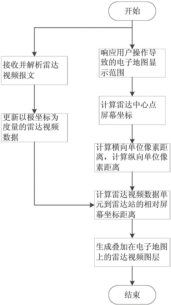
[0038] Aiming at the map data stored in the geographical coordinate system, the present invention adopts the characteristics of an electronic map projected in equal proportions of latitude and longitude, and proposes a method to directly convert the radar echo video data measured by polar coordinates into data measured by screen coordinates , and displayed on the electronic map, while ensuring that the radar echo video is consistent with the map data, it also reduces the amount of conversion calculations, and supports the real-time display function of the radar echo video of the VTS system.

[0039] Such as figure 1 As shown, the present invention proposes a radar echo video display method based on a geographic coordinate system, comprising steps as follows:

[0040] Step 1. Create thread 1 to receive radar echo messages and cache them.

[0041] 1-1 Analyze the message to generate radar echo data measured in polar coordinates;

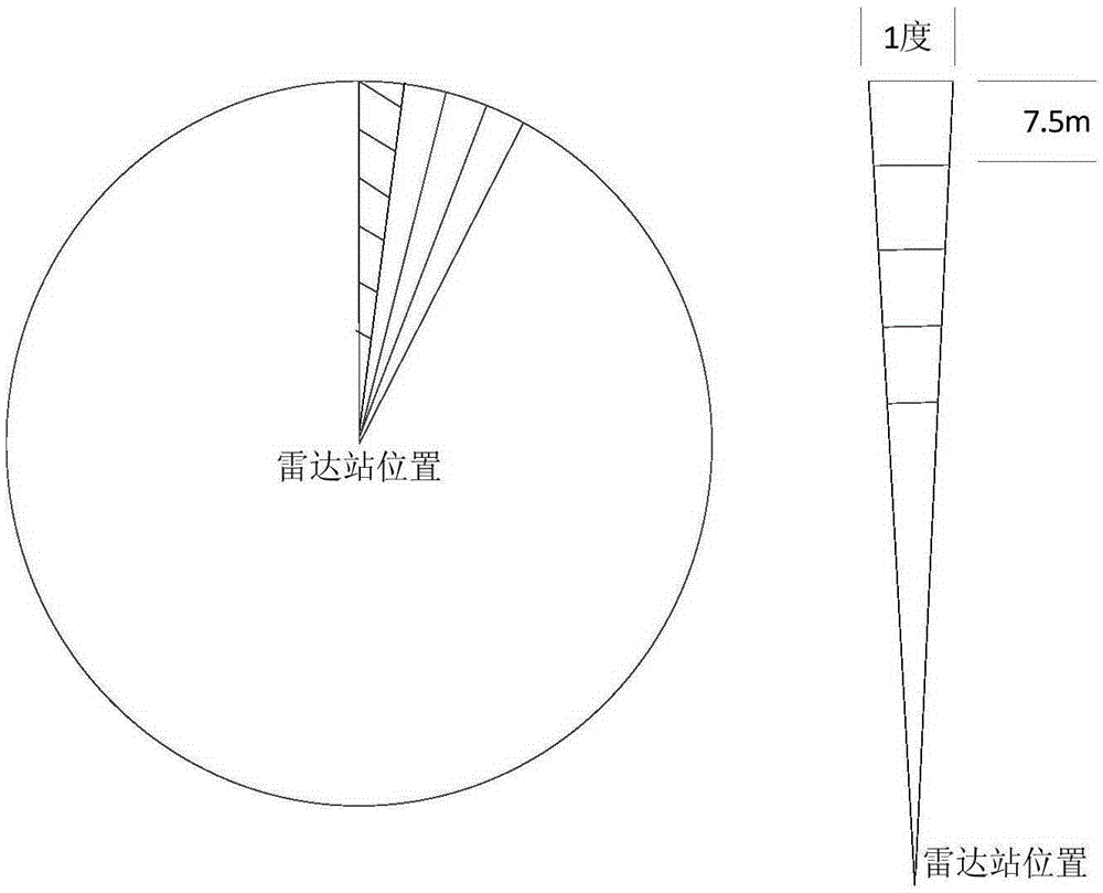
[0042] Such as figure 2 As shown, the area c...


PUM


Abstract

The invention discloses a VTS system radar return video display method based on a geographic coordinate system. The VTS system radar return video display method comprises the following steps: S1, the program of a VTS system is divided into two threads, wherein the thread I is responsible for receiving and caching a radar return message; S2, the thread II responds to electronic map indication range variation to generate a new to-be-overlapped radar return video map layer; S3, the generated radar return video map layer is overlapped on the current electronic map. With adoption of the VTS system radar return video display method, the radar return video display problem of a ship traffic management system, particularly to a system with the data format of the electronic map measured by the geographic coordinate system, is solved, and under the condition that the system overhead is acceptable, the VTS system radar return video display method ensures the position consistency of a radar return video and a ship target on the electronic map, is particularly suitable for the ship traffic management system, and is generally used for a single port, an offshore area and an inland river with smaller geographic display ranges, as well as a system allowing certain deformation of map projection.

Description

technical field [0001] The invention belongs to a computer radar echo video display method, in particular to a radar echo video display method based on a geographic coordinate system electronic map applied to a VTS ship traffic management system. Background technique [0002] In the vessel traffic management system (VTS system), there are several types of ship discovery methods, such as radar discovery and AIS reporting, among which radar discovery is one of the most important sources of real-time intelligence. The radar station filters the original video of the received radar echo through clutter to remove clutter such as waves and floating objects on the sea surface, and then forms a detection video measured in polar coordinates and sends it to the control center. After the control center receives the radar echo message, it will be superimposed and displayed on the electronic map. [0003] The electronic map is a map that the information system displays the map data set o...

Claims


Application Information

Patent Timeline
IPC IPC(8): G01S7/04
CPCG01S7/046
Inventor 隋远李小欢孙海军张由余顾晶薛雯
Owner THE 28TH RES INST OF CHINA ELECTRONICS TECH GROUP CORP
Why Eureka
Try Eureka