Precise LINDAR data ground object classification method based on adaptive characteristic weight synthesis

A classification method and self-adaptive technology, applied in image data processing, image analysis, instruments, etc., can solve problems such as not considering the correlation between evidences, achieve the effect of reducing the loss of feature information and improving classification accuracy

Active Publication Date: 2016-04-06
ZHONGBEI UNIV
View PDF3 Cites 23 Cited by
  • Summary
  • Abstract
  • Description
  • Claims
  • Application Information

AI Technical Summary

Benefits of technology

This patented technology allows an aircraft's radar sensor (LIDAR) can detect more accurate distance from targets than previous systems without sacrificing resolution or sensitivity. It uses this knowledge to create models called fuzzy sets which represent potential threatening scenarios while reducing their impact on overall performance. By selecting representative sample parts at random, we aim to reduce redundancy by replacing only certain ones rather than all them altogether. Additionally, our method optimizes weights used during analysis to improve object recognition results through correlations among various factors like altitude and target position. Overall, these technical improvements help prevent collateral damage caused by unintended detection events such as missiles or bomb attacks.

Problems solved by technology

This patented technical problem addressed in this patents relates to accurately identifying and categorizing ground materials due to their complex nature. Ground object recognition systems use laser radar imagery collected at multiple locations around the world's area to extract detailed spatially distributed reflectance values called aerial depth maps (ALSM). These map measurements help improve understanding terrain characteristics during autonomous driving operations like road safety monitoring and environmental pollution assessment. However, existing methods often neglect relevant factors involved in each measurement, leading to errors when selecting representative samples. Additionally, current techniques require extensive analysis effort because they cannot fully utilize all available sources of data.

Method used


Image

  • Precise LINDAR data ground object classification method based on adaptive characteristic weight synthesis
  • Precise LINDAR data ground object classification method based on adaptive characteristic weight synthesis
  • Precise LINDAR data ground object classification method based on adaptive characteristic weight synthesis

Examples


Embodiment Construction

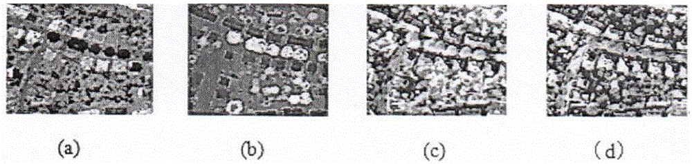
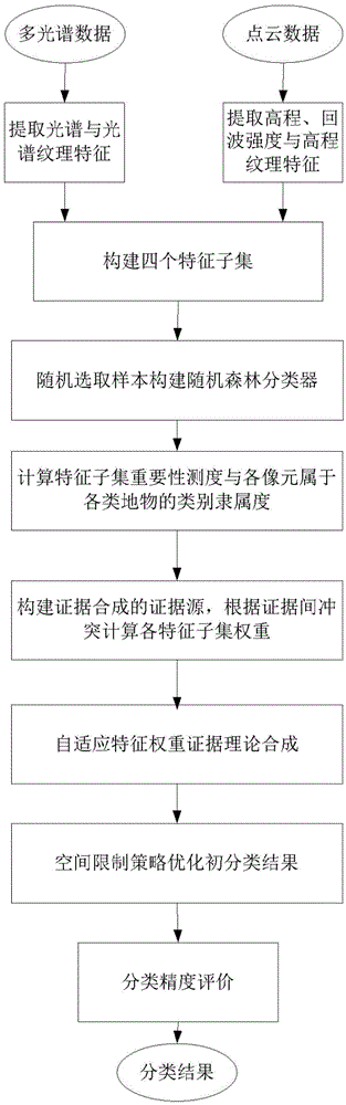
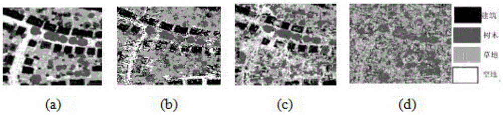
[0033] The experimental data of the present invention is collected by the Falcon II sensor of TopoSys company using optical fiber scanning mode, the flight height is about 600m, and the average laser foot point density and point spacing are respectively 4 points / m 2 and 0.5m, are registered to a 0.5m spatial resolution. Spectral data includes four bands of blue, green, red, and near-infrared, and elevation data includes the elevation of the first and last echoes. The measured area has a typical urban landform, and the real data is obtained manually as the ground truth. The specific implementation steps are as follows:

[0034] Such as figure 1 As shown, S1: Obtain the point cloud data of the LIDAR system and the multispectral data captured by the spectral camera, and perform median filter preprocessing;

[0035] S2: Extract the data features of the LIDAR system, and construct the elevation feature subset T according to the physical meaning and ground object information dist...


PUM


Abstract

The invention, which belongs to the remote sensing data ground object classification field, particularly relates to a precise LINDAR data ground object classification method based on adaptive characteristic weight synthesis. According to the invention, full feature information extraction is carried out on an experiment image, elevation, spectrum, intensity, and texture feature subsets are constructed based on the physical significance of the feature and a difference including ground object information; importance differences of different feature subsets during the ground object classification process are analyzed under a random forest frame, importance measures of all feature subsets are calculated, and class memberships of pixels to all kinds of ground objects are obtained; with comprehensive utilization of the importance measures of the feature subsets as well as an evidence-conflict-calculation-based weight coefficient, synthesis of multiple evidence sources formed by all feature subsets is carried out; and according to the synthesis result, precise ground object classification is realized by using a voting-based decision making rule and a preliminary classification result is optimized by employing an effective space limitation strategy.

Description


Claims


Application Information

Patent Timeline
Owner ZHONGBEI UNIV
Why Eureka
Try Eureka