A vehicle trajectory extraction method based on UAV aerial images

A vehicle trajectory and extraction method technology, applied in the field of image processing and traffic monitoring, can solve the problems of inability to obtain macroscopic traffic status data and traffic status, and achieve the effect of reducing the difficulty of distinction, reducing the number, and widening the field of vision

Active Publication Date: 2018-11-27
BEIHANG UNIV
View PDF8 Cites 0 Cited by
  • Summary
  • Abstract
  • Description
  • Claims
  • Application Information

AI Technical Summary

Problems solved by technology

Existing traffic monitoring methods mainly rely on cross-section detection methods such as cameras installed at fixed points (such as utility poles) and microwave radars, which cannot obtain macroscopic traffic status data, and traffic status cannot be obtained in places where monitoring equipment is not installed.

Method used


Image

  • A vehicle trajectory extraction method based on UAV aerial images
  • A vehicle trajectory extraction method based on UAV aerial images
  • A vehicle trajectory extraction method based on UAV aerial images

Examples


Embodiment Construction

[0023] The present invention will be further described in detail with reference to the accompanying drawings and embodiments.

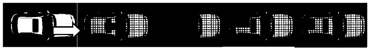
[0024] The present invention provides a vehicle trajectory extraction method based on unmanned aerial vehicle images, the method first processes the image sequence based on the Haar classifier to detect vehicles, and then realizes vehicle tracking based on position prediction and multi-channel color histogram similarity, and then Realize vehicle trajectory extraction. Here, the vehicle trajectory extraction of a vehicle is used to introduce the highway vehicle trajectory extraction algorithm based on aerial images. The trajectory extraction process of a single vehicle is as follows: Figure 6 As shown, the specific processing steps are as follows:

[0025] Step 1: Detect vehicles based on the Haar classifier;

[0026] For the UAV low-altitude aerial image sequence, a Haar-based classifier is used for vehicle detection, and the Haar feature used is ...


PUM


Abstract

The invention discloses a method for extracting vehicle tracks based on unmanned aerial vehicle images, comprising step 1: detecting vehicles based on a Haar classifier; step 2: screening suspected candidate vehicles based on position prediction; step 3: similarity based on 4-channel color histograms Determine the target vehicle; Step 4: Vehicle trajectory extraction; The innovative combination of multi-color histogram similarity of the present invention for target vehicle screening has a high degree of discrimination between the same vehicle and other vehicles; the vehicle trajectory extraction method described in When vehicle tracking is interrupted, it can automatically resume tracking.

Description

technical field [0001] The invention belongs to the technical field of image processing, relates to a method for extracting vehicle tracks based on low-altitude aerial images of unmanned aerial vehicles, and is applicable to the field of traffic monitoring. Background technique [0002] UAVs have great application prospects in the field of traffic monitoring, such as the application of UAVs for rapid traffic situation awareness under emergencies. Existing traffic monitoring methods mainly rely on cross-sectional detection methods such as cameras and microwave radars installed at fixed points (such as utility poles), which cannot obtain macroscopic traffic status data, and traffic status cannot be obtained at locations without monitoring equipment. The UAV itself is a mobile data collection platform. Compared with the fixed traffic monitoring method, it has the advantages of strong mobility, wide field of vision, and flying without ground restrictions. Therefore, it can reali...

Claims


Application Information

Patent Timeline
Patent Type & Authority Patents(China)
IPC IPC(8): G06K9/00G06K9/62
CPCG06V20/52G06V2201/08G06F18/24
Inventor 王云鹏徐永正余贵珍吴新开王章宇
Owner BEIHANG UNIV
Why Eureka
Try Eureka