A method and system for photoelectric ranging weather correction

A photoelectric ranging and meteorological technology, applied in radio wave measurement systems, electromagnetic wave reradiation, measuring devices, etc., can solve problems such as large errors and ranging errors, reduce representative errors, and achieve high-precision measurement. Reliable, easy Achieved effect

Inactive Publication Date: 2018-04-20
WUHAN UNIV
View PDF4 Cites 0 Cited by
  • Summary
  • Abstract
  • Description
  • Claims
  • Application Information

AI Technical Summary

Problems solved by technology

Since the distribution of meteorological elements on the actual propagation path of the ranging signal is not fixed, the error of this method is relatively large, especially when the distribution of the atmosphere is uneven, it will bring great errors to the ranging

Method used


Image

  • A method and system for photoelectric ranging weather correction
  • A method and system for photoelectric ranging weather correction
  • A method and system for photoelectric ranging weather correction

Examples


Embodiment Construction

[0035] The technical solution of the present invention will be described below in conjunction with the accompanying drawings.
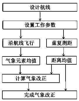
[0036] The core idea of ​​the present invention is to use the unmanned aerial vehicle to measure the meteorological elements of each point on the propagation path of the ranging signal, thereby eliminating the representative error of the meteorological elements caused by the traditional technical method.

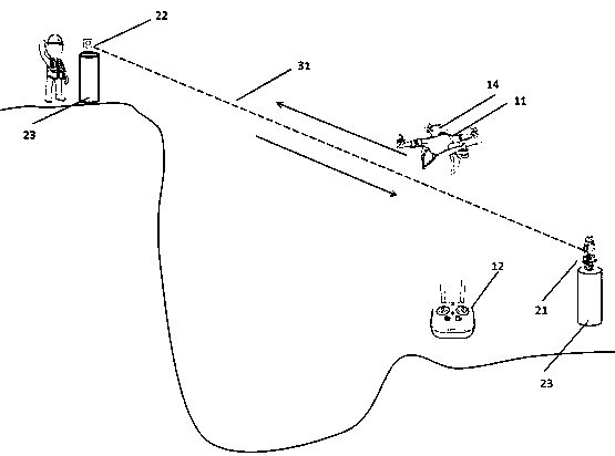
[0037] The ranging signal in the present invention includes electromagnetic waves, lasers, and infrared light. The photoelectric ranging instrument refers to an instrument that uses at least one of the aforementioned ranging signals to perform ranging, including but not limited to laser ranging instruments, Total station, 3D laser scanner.

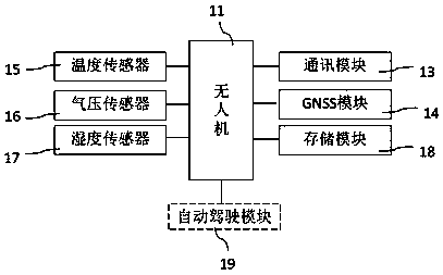
[0038] see figure 1 , an embodiment of the present invention provides a system for photoelectric ranging weather correction, including:

[0039] The ground control module 12 is used to control the flight state...


PUM


Abstract

The invention provides a method and system for photoelectric ranging meteorological correction. An unmanned aerial vehicle and a corresponding ground control module are arranged, and wireless communication of a ground control system and the unmanned aerial vehicle is established; a communication module, a GNSS module, a temperature sensor, a barometric sensor, a humidity sensor and a storage module are arranged on the unmanned aerial vehicle in a carrying mode; the unmanned aerial vehicle flies back and forth along a designed air route, a photoelectric ranging instrument performs repeated ranging on a target point many times in the period, and meteorological elements on a ranging signal transmission route are measured while ranging is performed; the average value of temperature, barometric pressure, humidity and distance is solved, and meteorological correction is achieved. The system is simple in structure, and labor division of modules is clear, steps of the method are clear, and the scheme can be achieved easily. By means of the method and system, the meteorological elements on the ranging signal transmission route can be accurately measured, meteorological element representativeness in the prior art can be greatly reduced, and therefore photoelectric ranging precision is improved, and a reliable guarantee is provided for high-precision measurement.

Description

technical field [0001] The invention belongs to the field of geodetic surveying and engineering surveying, and in particular relates to a method and system for photoelectric ranging weather correction. Background technique [0002] At present, photoelectric distance measurement is widely used in the field of geodetic survey and engineering survey. The so-called photoelectric ranging includes electromagnetic wave ranging, laser ranging and infrared ranging. Typical instruments include laser rangefinders, total stations, and three-dimensional laser scanners. Since light waves or electromagnetic waves propagate in the atmosphere, their speed will change and cause non-negligible effects. Therefore, in order to obtain high-precision ranging results, it is necessary to apply meteorological corrections to the distance observations. Due to limited conditions, the most commonly used method at present is to simultaneously measure meteorological elements such as dry and wet temperatur...

Claims


Application Information

Patent Timeline
Patent Type & Authority Patents(China)
IPC IPC(8): G01S17/08G01S7/48
CPCG01S7/48G01S17/08
Inventor 章迪郭际明梅文胜巢佰崇李昕周吕胡纪元王高靖许毅蔡婧王威赵胤植
Owner WUHAN UNIV
Why Eureka
Try Eureka