Map interface display method and device

An interface display and map technology, applied in geographic information databases, structured data retrieval, etc., can solve problems such as poor interface display effect, difficulty in paying attention to surrounding information, and poor information accuracy.

Active Publication Date: 2020-07-07
SHENZHEN TENCENT COMP SYST CO LTD
View PDF7 Cites 0 Cited by
  • Summary
  • Abstract
  • Description
  • Claims
  • Application Information

AI Technical Summary

Problems solved by technology

[0005] When displaying the map interface in the prior art, due to the existence of the center icon, the user's sight is concentrated on the center point, and it is difficult to pay attention to the surrounding information, the interface display effect is poor, and after the drag and drop is completed, only some images can be displayed based on the center point. option information to provide a limited service, the information provided is inaccurate, and the amount of information is limited

Method used


Image

  • Map interface display method and device
  • Map interface display method and device
  • Map interface display method and device

Examples


Embodiment Construction

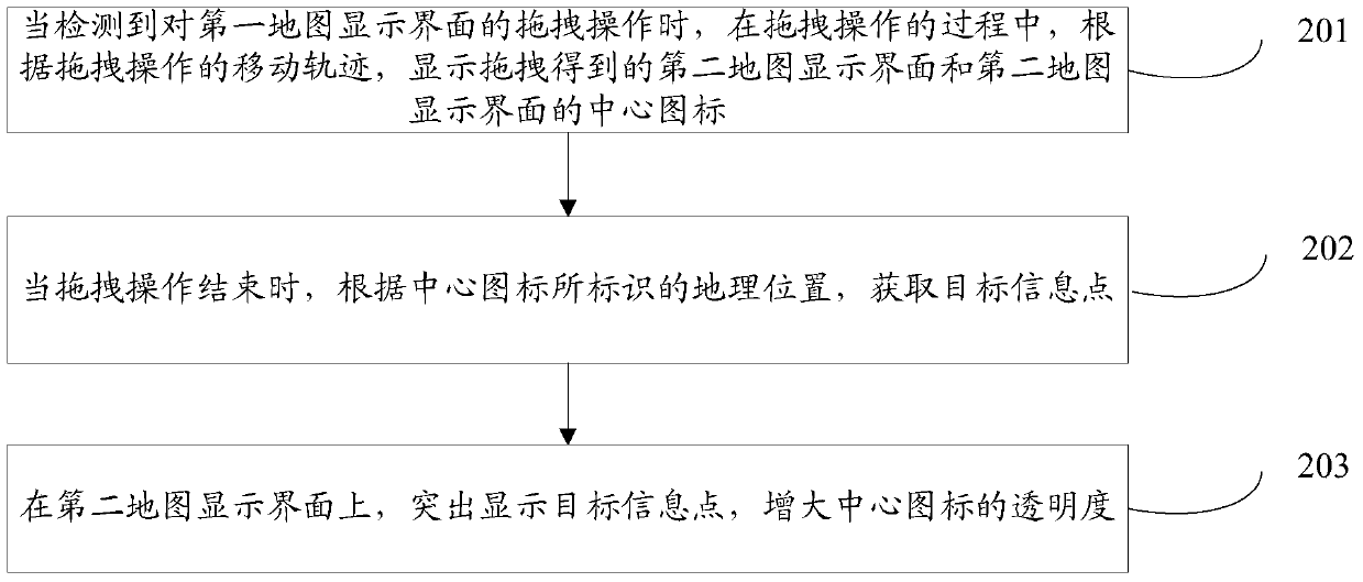
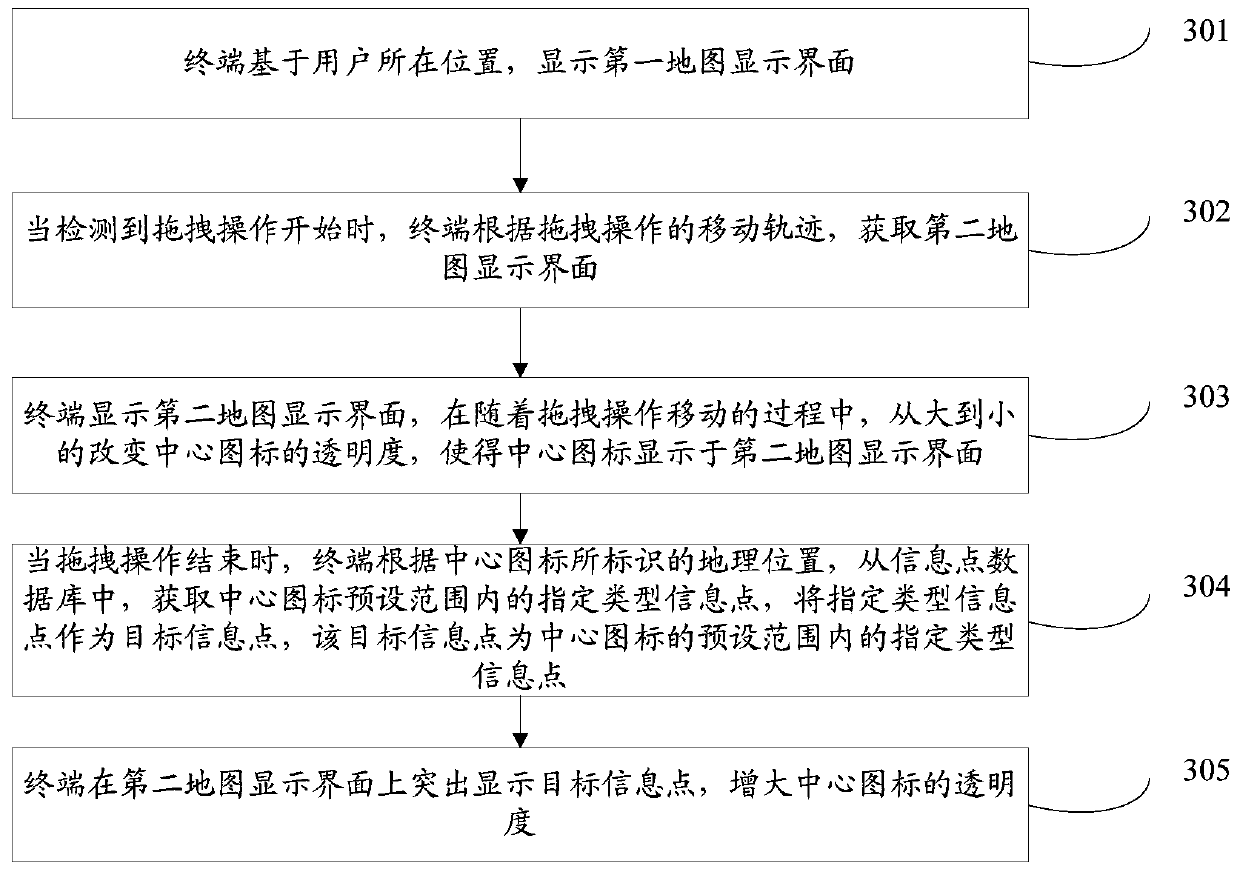
[0026] In order to make the object, technical solution and advantages of the present invention clearer, the implementation manner of the present invention will be further described in detail below in conjunction with the accompanying drawings.

[0027] In order to facilitate the understanding of the embodiments of the present invention, the following network systems are introduced here:

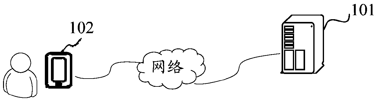
[0028] figure 1 It is a schematic diagram of a network system provided by an embodiment of the present invention. Such as figure 1 As shown, the network system may include a terminal 101 and a server 102 for providing geographic information services for the terminal 101, information exchange between the terminal 101 and the server 102 is based on a network connection, the server 102 is used for storing geographic information, and the terminal 101 The client installed on the terminal 101 can access the server to obtain map information, so as to provide users with services such as location na...


PUM


Abstract

The invention discloses a map interface display method and a map interface display device, belonging to the technical field of a terminal. The method comprises the following steps: when detecting drag operation of a first map display interface, displaying a second map display interface and a central icon of the second map display interface obtained by dragging according to a movement locus of the drag operation in the process of the drag operation; when the drag operation is finished, obtaining a target information point according to a geographical position marked by the central icon; and highlighting the target information point on the second map display interface and increasing the transparency of the central icon. According to the method and the device disclosed by the embodiment of the invention, by displaying the target information point at the periphery of a destination, more accurate geographical information is provided based on the target information point, and the amount of information is more; and after the drag operation is finished, by highlighting the target information point and increasing the transparency of the central icon, the user sight is guided to the target information point at the periphery, a display interface is clear and the guidance is strong.

Description

technical field [0001] The present invention relates to the technical field of terminals, in particular to a method and device for displaying a map interface. Background technique [0002] The development of terminal technology has brought many conveniences to people's life. For example, the map function of the terminal provides travel guidance for people. When people use the terminal to view the map, the terminal can display the map of a certain nearby area according to the user's current location or the location selected by the user, and provide services such as location navigation and route design. [0003] In the existing map display interface, the map is displayed with the user's position as the center point; when the user drags the map, a center icon will be displayed in the center of the map display interface after dragging; after the dragging is completed, when the user When the center icon is long pressed, option information such as navigation and route design can...

Claims


Application Information

Patent Timeline
Patent Type & Authority Patents(China)
IPC IPC(8): G06F16/29
Inventor 姜炳楠张云帆都人华李华锋
Owner SHENZHEN TENCENT COMP SYST CO LTD
Why Eureka
Try Eureka