Method for processing boundary filtering data in three-dimensional geological surface model

A surface model and three-dimensional geological technology, applied in the field of geographic information systems, can solve the problems of poor standardization of mesh units, inability to quantify geological structures, and low precision

Inactive Publication Date: 2016-08-24
ZHEJIANG UNIV CITY COLLEGE
View PDF7 Cites 0 Cited by
  • Summary
  • Abstract
  • Description
  • Claims
  • Application Information

AI Technical Summary

Problems solved by technology

[0004] The mesh unit in the 3D geological surface model constructed by the geographic information system has poor standardization and low precision, and it is impossible to conduct quantitative research on the geological structure

Method used

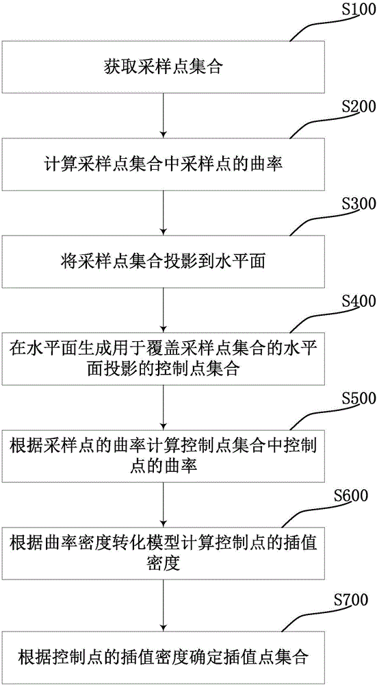
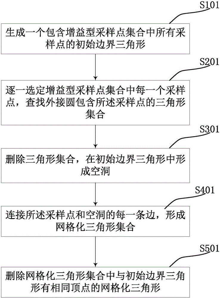
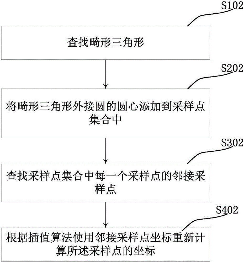

Image

  • Method for processing boundary filtering data in three-dimensional geological surface model
  • Method for processing boundary filtering data in three-dimensional geological surface model
  • Method for processing boundary filtering data in three-dimensional geological surface model

Examples


Embodiment Construction

[0023] In order to make the purpose, technical solution and advantages of the present application clearer, the technical solution of the present application will be clearly and completely described below in conjunction with specific embodiments of the present application and corresponding drawings. Apparently, the described embodiments are only some of the embodiments of the present application, rather than all the embodiments. Based on the embodiments in this application, all other embodiments obtained by persons of ordinary skill in the art without making creative efforts belong to the scope of protection of this application.

[0024] In geological research, a three-dimensional geological model can be established to visualize the geological structure, so that the geological structure can be visualized.

[0025] The geological position information obtained by geological exploration and some reference geological position information are inserted into the geological position in...


PUM


Abstract

The invention discloses a method for processing boundary filtering data in a three-dimensional geological surface model. The method includes the steps of inputting a set of all triangles and a set of all boundary lines, marking all boundary points, selecting any triangle in the set of triangles, determining whether the apex of the triangle is marked, classifying the triangle in a first curved surface set if the apex of the triangle is not marked, otherwise conducting no processing for the triangle, traversing all adjacent triangles of the first curved surface set, classifying the adjacent triangles into the first curved surface set if the apexes of the adjacent triangles are not marked and adjacent edges of the adjacent triangles and the triangle do not belong to the set of all boundary lines, and repeating the previous step until a stable first curved surface set is obtained. The first curved surface set corresponds to an independent spatial section in space, so that the stratum shape can be recovered. The method facilitates quantified research of geological structures.

Description

technical field [0001] This application relates to the field of geographic information systems, in particular to a data processing method in a three-dimensional geological surface model. Background technique [0002] When processing data in the existing 3D geological surface model in the geographic information system, the focus of the research is on the simulation of the geological structure, that is, the rendering and visualization of the geological structure. [0003] In the process of implementing the prior art, the inventors found that at least the following problems existed in the prior art: [0004] The mesh unit in the 3D geological surface model constructed by the geographic information system has poor standardization and low precision, so it is impossible to carry out quantitative research on the geological structure. For example, research on cracks, faults, etc. in geological structures based on a three-dimensional geological surface model. Contents of the inven...

Claims


Application Information

Patent Timeline
Patent Type & Authority Applications(China)
IPC IPC(8): G06T19/00
CPCG06T19/00
Inventor 翁文勇唐培培孙霖王泽兵苏健戴晓霞
Owner ZHEJIANG UNIV CITY COLLEGE
Why Eureka
Try Eureka