Drawing method for crescent dune map symbol based on sand ridge line

A map symbol and crescent-shaped technology, applied in the field of cartography, can solve the problems of loss of map scalability, time-consuming and labor-intensive, large investment of manpower and material resources, etc., to achieve the effect of improving visualization and shortening the publishing process

Inactive Publication Date: 2016-08-31
CHINA UNIV OF GEOSCIENCES (WUHAN)
View PDF1 Cites 2 Cited by
  • Summary
  • Abstract
  • Description
  • Claims
  • Application Information

AI Technical Summary

Problems solved by technology

[0005] (1) There are often many sand dunes in the distribution area of ​​barchan dunes. The traditional method of manually drawing barchan dune map symbols is time-consuming and labor-intensive, with a huge workload, requiring a lot of manpower and material resources;
[0006] (2) In the distribution area of ​​barchan dunes, the existing maps often indicate the existence of barchan dunes by randomly arranging map symbols of barchan dunes, without taking into account the real location information of individual barc

Method used


Image

  • Drawing method for crescent dune map symbol based on sand ridge line
  • Drawing method for crescent dune map symbol based on sand ridge line
  • Drawing method for crescent dune map symbol based on sand ridge line

Examples


Embodiment Construction

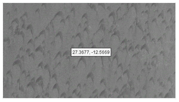
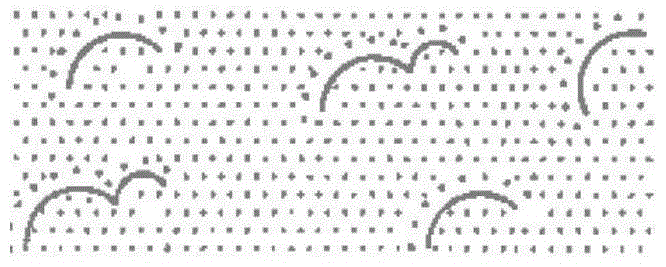
[0055] The present invention provides a method for drawing map symbols of barchan dunes based on sand ridge lines, making full use of existing barchan dune ridge line data, and extracting endpoints on the basis of ensuring the precise position of each barchan dune individual , vertices, connection points of the barchan dune chain and other feature points, and invert the morphological parameter values ​​(such as length, width, etc.) of the barchan dune, thereby constructing the barchan dune contour line, and then completing the The automatic drawing of symbols can solve the problems of low drawing efficiency, inaccurate positioning, and failure to reflect the real shape of barchan dunes.

[0056] In order to enable those skilled in the technical field to which the application belongs to understand the application more clearly, the technical solutions of the application will be described in detail below through specific embodiments in conjunction with the accompanying drawings. ...


PUM


Abstract

The invention discloses a drawing method for a crescent dune map symbol based on a sand ridge line. The drawing method comprises the following steps that form feature points of the sand ridge line are extracted based on the existing crescent dune sand ridge line data on the basis of keeping the mutual relation of crescent dune form factors (length, width and height, etc.); the form parameter values of a crescent dune are calculated; the contour line of the crescent dune is drawn; the windward slope and the leeward slope of the crescent dune are constructed; and filling of the windward slope color and the leeward slope color of the crescent dune is performed so that drawing of the crescent dune map symbol is realized. The form features of all the single crescent dunes of different crescent dune distribution areas can be really reflected on the basis of guaranteeing high-efficiency operation.

Description

technical field [0001] The present application relates to the field of cartography, in particular to a method for drawing map symbols of barchan dunes based on sand ridge lines. Background technique [0002] 1 / 3 of the world's total land area is covered by deserts or sandy land, of which sand dunes account for more than 80%. Among the different types of sand dunes, barchan dunes are the most common, widely distributed in the edges of the world's major deserts, river valleys, dry salt lakes, coastal areas. [0003] In the field of cartography, barchan dunes, as an important type of sandy landform, have received little attention. Due to the lack of automatic drawing methods for barchan dune map symbols, there is no barchan dune landform on many two-dimensional electronic maps. to express. For example, the satellite images of a map program show that there are a large number of barchan dunes near 27°22′N latitude and 12°34′W longitude (such as Figure 1A ), but there is no cor...

Claims


Application Information

Patent Timeline
IPC IPC(8): G06T11/20G09B29/00G09B29/10
CPCG06T11/206G09B29/003G09B29/10
Inventor 杨乃田玉刚胡伟路陈诗漪
Owner CHINA UNIV OF GEOSCIENCES (WUHAN)
Why Eureka
Try Eureka