A gps receiver for suspended surveying and mapping of water bodies

A technology of GPS receivers and receivers, applied in measuring devices, radio wave measurement systems, satellite radio beacon positioning systems, etc., can solve problems such as circuit board short circuit, failure to place, GPS receiver surveying and mapping instrument chip corrosion, etc., to achieve Good processability, reliable waterproof performance, and the effect of reducing the impact of wind and waves on it

Inactive Publication Date: 2017-12-08
麟州(巨野)孵化器有限公司
View PDF6 Cites 0 Cited by
  • Summary
  • Abstract
  • Description
  • Claims
  • Application Information

AI Technical Summary

Problems solved by technology

However, in the surveying and mapping of islands (reefs) or inland water bodies, due to shallow water, shoals, reefs and other environments, it is difficult for large survey ships to enter, and the GPS receiver cannot be placed independently in any position in the shallow water area.
[0004] Moreover, the current receiver has no protective measures, and is usually wrapped with a plastic film. Humid environments usually cause corrosion of the internal chip of the GPS receiver surveying instrument, short circuit of the circuit board, etc., resulting in work delays and large property losses.
[0005] The development of the present invention is a GPS receiver with self-maneuvering performance, which is used to solve the problem that it cannot be placed in the surveying and mapping of islands (reefs) or inland water bodies

Method used


Image

  • A gps receiver for suspended surveying and mapping of water bodies
  • A gps receiver for suspended surveying and mapping of water bodies
  • A gps receiver for suspended surveying and mapping of water bodies

Examples


Embodiment Construction

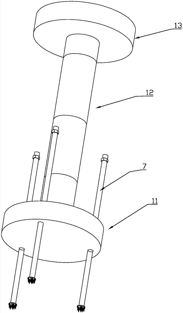
[0047] Below in conjunction with specific embodiment, refer to Figure 1 to Figure 14 , a GPS receiver for suspended water body surveying and mapping, including a controllable self-sinking body 1 for arranging the GPS receiver and taking waterproof and sealing measures, and a motorized body 1 for arranging lithium batteries and power systems and taking waterproof and sealing measures. The body 2, the controllable self-settling body and the mobile body are connected through a hose 3 and cables to form a flexible link.

[0048] Wherein, the mobile body 2 has self-mobility capability, and can drive the controllable self-settling body to maneuver and drag it to a predetermined location. The mobile body supplies electric energy to the controllable self-sinking body through the cable between the two.

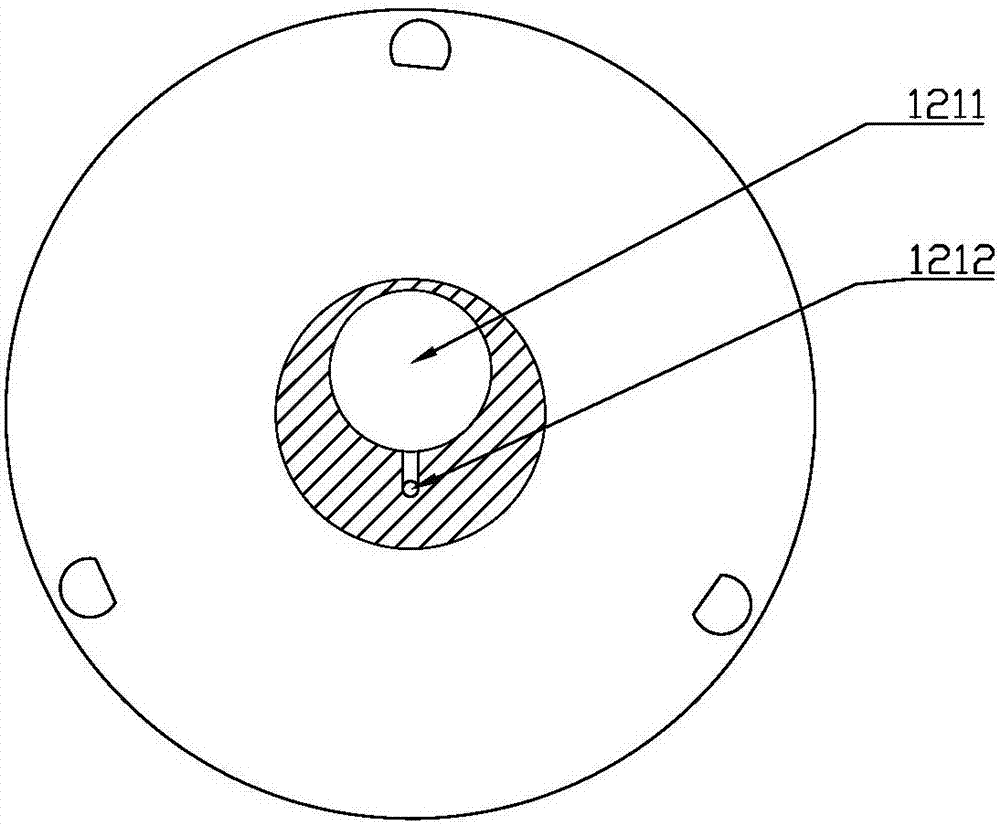
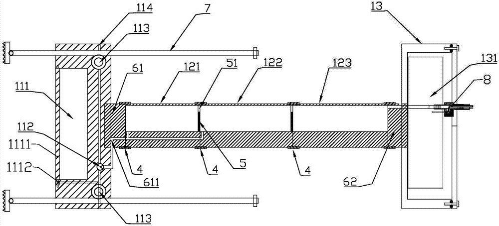
[0049]The controllable self-settling body 1 includes a support part 11, a floating body part 12 and a warehouse 13, wherein the floating body part 12 is composed of three buoys, and ...


PUM


Abstract

The invention discloses a GPS receptor used for water body suspension mapping and is used for solving a problem of GPS receiver mounting inconvenience. The GPS receptor includes a controllable self setting body used for mounting the GPS receiver and adopting a waterproof sealing measure and an engine driven body provided with a built-in power system and adopting a waterproof sealing measure. The controllable self setting body and the engine driven body are connected to each other through nylon ropes and cables. The engine driven body has self drive capability and can drive the self setting body to move and pull the self setting body to predetermined locations. Besides, the engine driven body supplies electric power for the controllable self setting body through the cables between the engine driven body and the controllable self setting body. The controllable self setting body includes a support part, a floating body part and a cargo cabin. The GPS receiver is mounted in the cargo cabin. According to the invention, the GPS receptor holds the GPS receiver and floats on the water face and can also go down into water in a submersible manner. Besides, the GPS receptor has a self driving performance, so that convenience is made for geographical mapping and locating.

Description

technical field [0001] The invention relates to a GPS receiver used in surveying and mapping engineering, in particular to a special instrument used in the surveying and mapping of sea islands (reefs) or inland water bodies, which has certain self-mobility and self-floating capabilities. Background technique [0002] GPS receiver is an instrument that receives signals from Global Positioning System satellites and determines the spatial position on the ground. It is widely used in geographic surveying and mapping projects. The navigation and positioning signals sent by GPS satellites are an information resource that can be shared by countless users. For the vast number of land, ocean and space users, as long as they have receiving equipment capable of receiving, tracking, transforming and measuring GPS signals, that is, GPS signal receivers. [0003] When the current GPS receiver is generally hand-held, it is not a big problem to carry out surveying and mapping work on land ...

Claims


Application Information

Patent Timeline
Patent Type & Authority Patents(China)
IPC IPC(8): G01S19/14
CPCG01S19/14
Inventor 陈淑清李吉英
Owner 麟州(巨野)孵化器有限公司
Why Eureka
Try Eureka