Cell scanning and GPS trajectory interpolation-based agricultural machinery tillage area measurement and calculation method

A cell and agricultural machinery technology, which is applied in the field of agricultural machinery cultivation area measurement and calculation, can solve the problem of low measurement accuracy and achieve the effect of improving calculation efficiency and high accuracy

Active Publication Date: 2016-12-21
HARBIN INST OF TECH
View PDF6 Cites 11 Cited by
  • Summary
  • Abstract
  • Description
  • Claims
  • Application Information

AI Technical Summary

Problems solved by technology

[0003] The present invention aims to solve the problem of low calculation accuracy of the existing methods for measuring and calculating the cultivated area of ​​agric...

Method used


Image

  • Cell scanning and GPS trajectory interpolation-based agricultural machinery tillage area measurement and calculation method
  • Cell scanning and GPS trajectory interpolation-based agricultural machinery tillage area measurement and calculation method
  • Cell scanning and GPS trajectory interpolation-based agricultural machinery tillage area measurement and calculation method

Examples


specific Embodiment approach 1

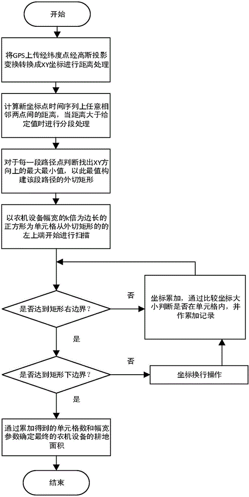
[0019] Specific embodiments one, based on cell scanning and GPS track interpolation method for measuring and calculating the farming area of ​​agricultural machinery,

[0020] Step 1, using the GPS positioning device installed on the agricultural machinery equipment, collecting the latitude and longitude coordinates of the agricultural machinery equipment every time t, and converting the latitude and longitude coordinates collected into XY coordinates under the plane Cartesian coordinate system according to the Gaussian projection transformation method;

[0021] Step 2. Use the time series in step 1 as the original time series. If the distance between adjacent coordinates is greater than the preset value M meters, perform segmentation processing, and M is a positive number;

[0022] After subsection processing, the k-segment coordinate point set C is obtained i , i=1,...,k, and then insert the coordinate points of the original time series into k segment coordinate points in an...

specific Embodiment

[0030] Assume that the latitude and longitude uploaded by the GPS device at a certain moment are longitude and latitude (in degrees).

[0031] Calculate the arc corresponding to 1° as iPI=π / 180.0.

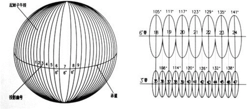
[0032] Such as figure 2 As shown, the method of sub-zonal projection is adopted, so that the deformation of the projection edge will not be too large: ZoneWide=6, that is, a 6° zone.

[0033] The parameters of the coordinate system are selected from the parameters of the Beijing coordinate system in 1954:

[0034] The length of the semi-major axis of the ellipsoid: a=6378137.0

[0035] The length of the semi-minor axis of the ellipsoid: b=6356752.3142

[0036] Convert latitude and longitude to radians longitude1 and latitude1 respectively:

[0037] longitude1=longitude*iPI

[0038] latitude1=latitude*iPI

[0039] Find the band number:

[0040] ProjNo=longitude / ZoneWide

[0041] longitude0=ProjNo*ZoneWide+ZoneWide / 2

[0042] Get the central meridian: longitude2=longi...


PUM


Abstract

The invention relates to a cell scanning and GPS trajectory interpolation-based agricultural machinery tillage area measurement and calculation method and belongs to the GPS trajectory information-based agricultural machinery tillage area measurement and calculation technical field. The objective of the present invention is to solve the problem of low accuracy of existing agricultural machinery tillage area measurement and calculation method. According to the method of the invention, latitude and longitude points are uploaded and are subjected to interpolation processing, so that the area of tilled land is marked, and with interpolation adopted, the precision level of area measurement and calculation reaches to a high level; maximum and minimum values in an X direction and a Y direction are judged according to coordinate values, and the circumscribed rectangle of a tilled land path is determined; with the tillage breadth of the agricultural machinery adopted as the edge of each cell, cumulative scanning is carried out on the cells from one end of the circumscribed rectangle, if interpolation points exist in the cells, so that accumulation recording is carried out; and final tillage area is calculated according to the number of accumulated cells. The method of the invention is applicable to the agricultural machinery tillage area measurement and calculation conditions.

Description

technical field [0001] The invention relates to a technique for measuring and calculating the cultivated area of ​​agricultural machinery based on GPS track information. Background technique [0002] Land area measurement is a very important work content in cadastral surveying. It provides a data basis for adjusting the land use structure, rationally allocating land, formulating national economic plans, agricultural zoning and land use planning, etc. Land area measurement includes the measurement of administrative jurisdiction, parcels of land, agricultural cultivation and other areas. At present, there are two methods of land area measurement and calculation, that is, the analytical method of area measurement and the graphical method of area measurement. The analytical method has a slow calculation speed due to the complex operation, while the graphical method often does not meet the accuracy requirements due to equipment and human factors. Contents of the invention ...

Claims


Application Information

Patent Timeline
IPC IPC(8): G01B7/32
CPCG01B7/32
Inventor 尹振东郭铁成吴芝路张瑞鹏杨柱天
Owner HARBIN INST OF TECH
Why Eureka
Try Eureka