
Image taking method and device, and unmanned aerial vehicle

A technology of image capture and UAV, applied in the field of flight control, can solve the problems of high price, complicated operation of UAV flight control, high cost of use, etc., and achieve the effect of reducing professional requirements

Active Publication Date: 2017-03-08
BEIJING XIAOMI MOBILE SOFTWARE CO LTD +1
View PDF5 Cites 27 Cited by
  • Summary
  • Abstract
  • Description
  • Claims
  • Application Information

AI Technical Summary

Problems solved by technology

[0003] However, the flight control operation of professional drones is complicated and expensive, resulting in extremely high cost of use

Method used


Image

  • Image taking method and device, and unmanned aerial vehicle
  • Image taking method and device, and unmanned aerial vehicle
  • Image taking method and device, and unmanned aerial vehicle

Examples


Embodiment Construction

[0061] The exemplary embodiments will be described in detail here, and examples thereof are shown in the accompanying drawings. When the following description refers to the accompanying drawings, unless otherwise indicated, the same numbers in different drawings represent the same or similar elements. The implementation manners described in the following exemplary embodiments do not represent all implementation manners consistent with the present disclosure. Rather, they are only examples of devices and methods consistent with some aspects of the present disclosure as detailed in the appended claims.

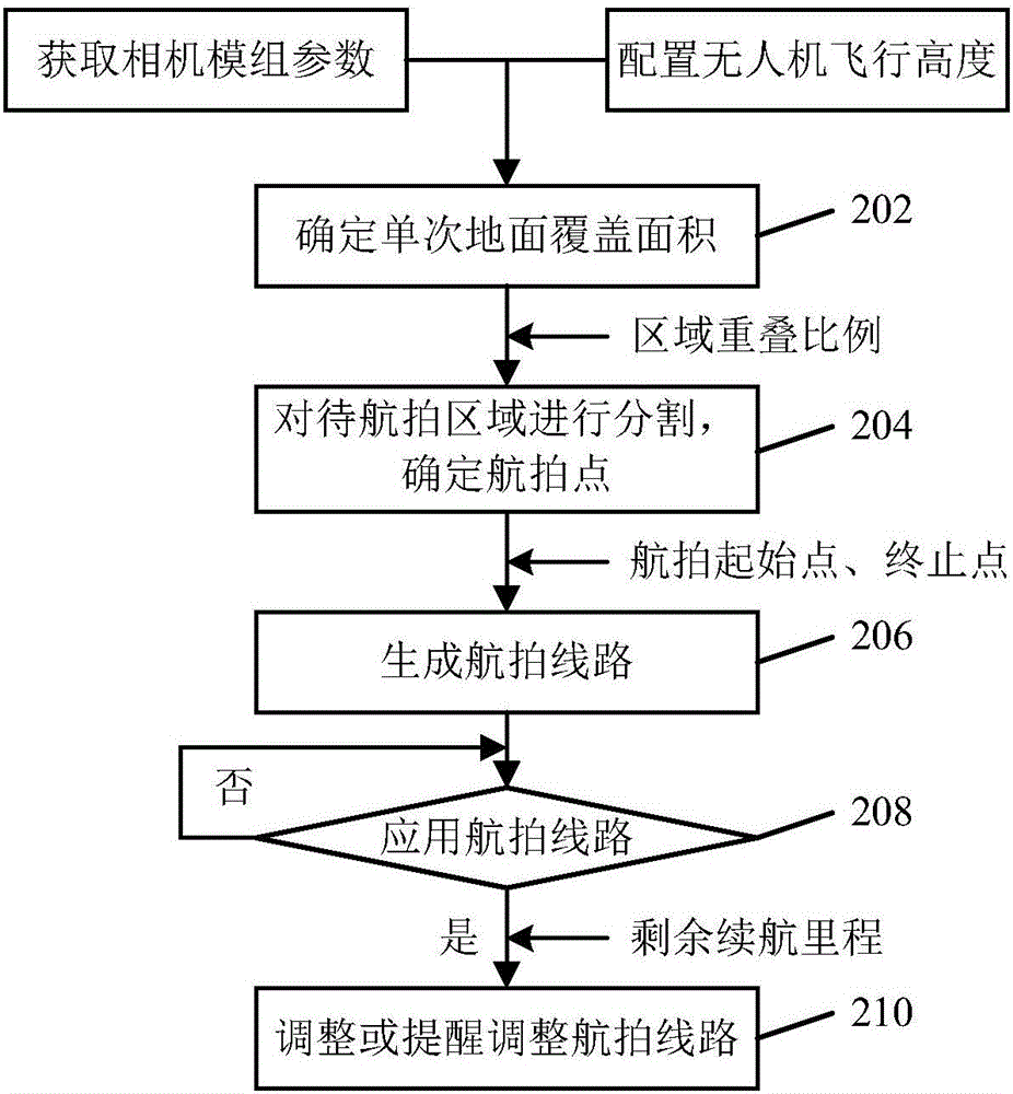
[0062] figure 1 Is a flowchart of an image shooting method according to an exemplary embodiment, such as figure 1 As shown, the method is applied to drones and can include the following steps:

[0063] In step 102, according to the single ground coverage area of ​​the drone when the orthophoto is taken, the pre-defined area overlap ratio between adjacent images, and the total ground...


PUM


Abstract

The disclosure relates to an image taking method and device and an unmanned aerial vehicle; the method comprises: according to single ground coverage area, predefined area superposition ratio of adjacent images, and total ground coverage area of an area to be aerially photographed when the unmanned aerial vehicle takes an orthophoto map, segmenting the area to be aerially photographed to produce an aerial photography point corresponding to each segmented sub-area; according to positional information of all aerial photography points, generating an aerial photography path to allow the unmanned aerial vehicle to take orthophoto maps for the area to be aerially photographed according to the aerial photography path. By using the technical scheme disclosed herein, it is possible to make automated planning for an aerial photography path for the area to be aerially photographed, planning before aerial photography is simplified, and aerial photography efficiency is improved.

Description

Technical field [0001] The present disclosure relates to the field of flight control technology, in particular to an image shooting method and device, and an unmanned aerial vehicle. Background technique [0002] UAVs are being used more and more widely in various fields, such as aerial photography, rescue, exploration, surveying and mapping. In different application fields, there are different application requirements for UAVs. For example, civilian-level drones can be used in aerial photography, rescue and other fields, but for professional fields such as exploration and surveying, it needs to be implemented by professionals through professional drones to ensure measurement accuracy. [0003] However, the flight control operation of professional drones is complicated and expensive, resulting in extremely high cost of use. In fact, in some scenarios where accuracy requirements are not too high, civilian drones can already fully meet the needs of use in hardware. Therefore, how t...

Claims


Application Information

Patent Timeline
Patent Type & Authority Applications(China)
IPC IPC(8): B64C27/08B64C39/02B64D47/08G05D1/00G05D1/02H04N7/18
CPCB64C27/08B64C39/02B64D47/08G05D1/0202H04N7/18
Inventor 陈佳冀映辉蔡炜吕宪伟刘新阳
Owner BEIJING XIAOMI MOBILE SOFTWARE CO LTD
Learn More