A Method for Establishing Perspective 3D Model of Underground Environment

A technology of three-dimensional model and establishment method, applied in the field of data processing, can solve the problem of inability to build a perspective three-dimensional model of detection results, and achieve the effect of intuitive display

Inactive Publication Date: 2019-06-14
合肥市勘察院有限责任公司
View PDF7 Cites 0 Cited by
  • Summary
  • Abstract
  • Description
  • Claims
  • Application Information

AI Technical Summary

Problems solved by technology

[0004] The purpose of the present invention is to solve the defect in the prior art that geological radar cannot establish a perspective three-dimensional model for detection results, and to provide a method for establishing a perspective three-dimensional model of an underground environment to solve the above problems

Method used


Image

  • A Method for Establishing Perspective 3D Model of Underground Environment
  • A Method for Establishing Perspective 3D Model of Underground Environment

Examples


Embodiment Construction

[0032] In order to have a further understanding and understanding of the structural features of the present invention and the achieved effects, the preferred embodiments and accompanying drawings are used for a detailed description, as follows:

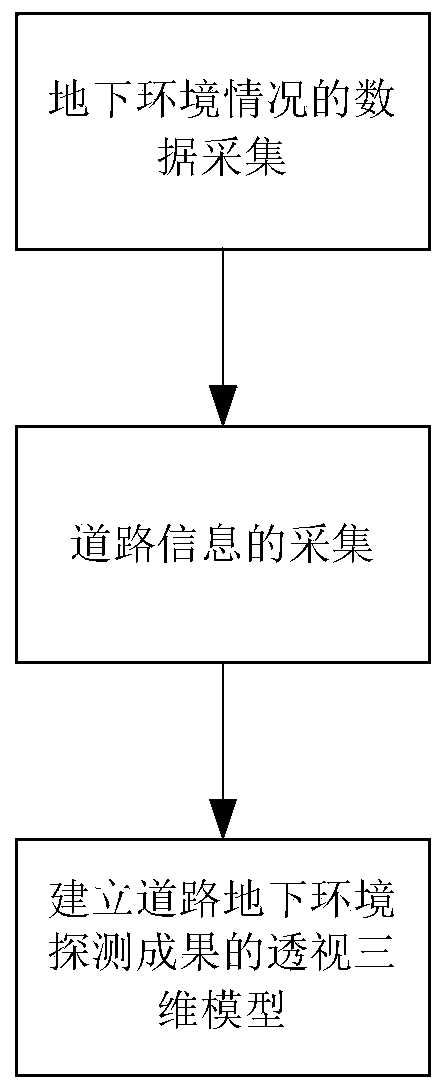
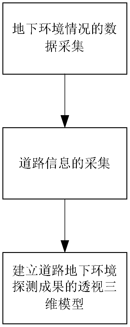
[0033] Such as figure 1 As shown, a method for establishing a perspective three-dimensional model of an underground environment according to the present invention comprises the following steps:

[0034] The first step is the data collection of the underground environment. The vehicle-mounted three-dimensional ground penetrating radar is used to collect the geological condition information of the underground environment, and the abnormal detection model is initially established through data extraction technology. Through the collection and use of vehicle-mounted 3D ground penetrating radar, abnormal geological environments such as underground hollow areas can be found. The specific steps are as follows:

[0035] (1) Determine the GP...


PUM


Abstract

The invention relates to an underground environment perspective three-dimensional model establishment method based on a vehicle-mounted three-dimensional ground penetrating radar and a road surveying and mapping technology. Compared with the prior art, the provided method enables a defect that the geological radar can not establish a perspective three-dimensional model for a detection result to be overcome. The method comprises the following steps: step one, carrying out underground environment situation data collection; to be specific, collecting geological conditions information of an underground environment by using a vehicle-mounted three-dimensional ground penetrating radar and establishing a detection abnormity model primarily by using a data extraction technique; step two, carrying out road information collection; to be specific, measuring a coordinate and elevation of road pavement information by means of surveying and measuring and establishing a road pavement model; and step three, establishing a perspective three-dimensional model of a road underground environment detection result and inputting the detection abnormity model into the road pavement model according to coordinate information, thereby forming a perspective three-dimensional model of the underground environment. Therefore, the result of three-dimensional ground penetrating radar detection is converted into the needed three-dimensional model, thereby forming the perspective three-dimensional model of the underground detection result.

Description

technical field [0001] The invention relates to the technical field of data processing, in particular to a method for establishing a perspective three-dimensional model of an underground environment. Background technique [0002] With the construction and rapid development of cities, more and more municipal projects are using ground radar for underground area survey and detection. However, the detection results of geological radar are all flat, and it is difficult to explain and display the abnormal areas detected intuitively, especially the digital connection of data to urban underground information has always been a problem. The vehicle-mounted 3D ground penetrating radar detection technology is rarely used in China, and it cannot convert the detection results into a 3D model. However, most of the existing 3D modeling technologies belong to the surface 3D in the traditional sense, which can form a 3D representation on the surface, but cannot be displayed inside, that is, ...

Claims


Application Information

Patent Timeline
Patent Type & Authority Patents(China)
IPC IPC(8): G06T17/00G01S13/88
CPCG01S13/885G06T17/00
Inventor 董双林苏先志
Owner 合肥市勘察院有限责任公司
Why Eureka
Try Eureka