Polygon accurate drawing method based on electronic map and application method thereof

An electronic map and polygonal technology, applied in maps/plans/charts, educational tools, instruments, etc., can solve the problems of inability to accurately distinguish fuzzy borders of rivers and roads, non-overlapping, overlapping of adjacent borders, etc., to avoid border overlap or inconsistency fit effect

Inactive Publication Date: 2017-05-10
YTO EXPRESS CO LTD
View PDF5 Cites 29 Cited by
  • Summary
  • Abstract
  • Description
  • Claims
  • Application Information

AI Technical Summary

Problems solved by technology

[0006] The purpose of the present invention is to solve the above problems. It provides a method for accurately drawing polygons based on an electronic map and its application method, which solves the problem of being unable to accurately distinguish fuzzy boundaries such as rivers and roads when drawing a single covering based on an electronic map, and drawing multiple polygons. Adjacent borders are prone to overlap and misalignment when covering

Method used


Image

  • Polygon accurate drawing method based on electronic map and application method thereof
  • Polygon accurate drawing method based on electronic map and application method thereof
  • Polygon accurate drawing method based on electronic map and application method thereof

Examples


no. 1 example

[0034] figure 1 The flowchart of the first embodiment of the electronic map-based polygon precise drawing method of the present invention is shown. See figure 1 , the specific implementation of the method in this embodiment is as follows.

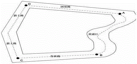
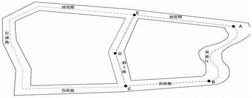
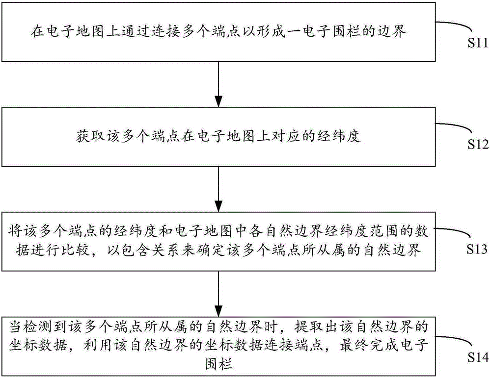
[0035] Step S11: Form a boundary of an electronic fence by connecting multiple endpoints on the electronic map.

[0036] Step S12: Obtain the latitude and longitude corresponding to the plurality of endpoints on the electronic map.

[0037] Step S13: Compare the latitude and longitude of the plurality of endpoints with the data of the latitude and longitude range of each natural boundary in the electronic map, and determine the natural boundaries to which the endpoints belong according to the inclusion relationship.

[0038] Step S14: When the natural boundary to which the multiple endpoints belong is detected, extract the coordinate data of the natural boundary, use the coordinate data of the natural boundary to connect the endpoints, a...


PUM


Abstract

The invention discloses a polygon accurate drawing method based on an electronic map and an application method thereof. Problems that based on the electronic map, during drawing of a single covering, rivers, roads, and fuzzy boundaries cannot be discriminated accurately, and during the drawing of a plurality of polygon coverings, the adjacent boundaries are easy to overlap and are not superposed are solved. The technical scheme provided by the invention is characterized in that by connecting a plurality of endpoints, a boundary of an electronic fence is formed on the electronic map; the corresponding longitudes and the corresponding latitudes of the plurality of endpoints in the electronic map are acquired; the longitudes and the latitudes of the plurality of endpoints are compared with the data of the longitude and latitude ranges of the natural boundaries of the electronic map, and the natural boundaries of the plurality of endpoints are determined by an inclusion relation; when the natural boundaries of the plurality of endpoints are detected, the coordinate data of the natural boundaries is extracted, and the endpoints are connected by using the coordinate data of the natural boundaries, the electronic fence is finally completed.

Description

technical field [0001] The invention relates to an electronic map drawing technology, in particular to a method for accurately drawing a polygonal area of ​​an electronic map and an application method thereof. Background technique [0002] With the rapid development of the national economy, the overlay drawing method based on electronic maps has gradually been applied in urban management, enterprise network distribution, logistics distribution and all aspects of people's daily life. For example, the service scope of a chain service store is accurately drawn on an electronic map, and the user locates the current latitude and longitude through the mobile APP and webpage later, and the system can automatically determine the service outlet closest to the current user point. [0003] At present, among the common map drawing tools at home and abroad, the fixed-point symbol method, line symbol method, range method, node editing method, etc. are usually used. Based on the map API, p...

Claims


Application Information

Patent Timeline
Patent Type & Authority Applications(China)
IPC IPC(8): G09B29/00
CPCG09B29/005
Inventor 曾松谢喜财杨俊明王贺荷钟丽
Owner YTO EXPRESS CO LTD
Why Eureka
Try Eureka