Check patentability & draft patents in minutes with Patsnap Eureka AI!

A method for calculating and confirming coverage areas of multi-satellite sensors for earth observation

A coverage area and earth observation technology, applied in the transmission system, radio transmission system, network planning, etc., can solve the problems that cannot take into account special circumstances, edge coincidence, and vertex coincidence, etc., so as to avoid complexity, The effect of high accuracy

Active Publication Date: 2017-11-10
武汉中地大智慧城市研究院有限公司
View PDF4 Cites 0 Cited by
  • Summary
  • Abstract
  • Description
  • Claims
  • Application Information

AI Technical Summary

Problems solved by technology

From a technical point of view, the problem of solving the entire area covered by multi-satellite sensor observations is actually a problem of merging multiple polygons. Known effective algorithms such as the Weiler algorithm can perform effective merging of concave and convex polygons, but it is Special cases such as edge coincidence and vertex coincidence are not considered; in addition, algorithms such as Sutherland-Hodgeman can also effectively clip polygons, but these algorithms require polygons to be rectangles, which are not applicable in most practical situations
To sum up, it can be seen that the current algorithms for polygon union either limit the shape of polygons, or cannot take into account some common special cases.
In view of the demand for quantitative assessment of multi-satellite sensor cooperative observation capabilities, there is currently a lack of methods for calculating and confirming the coverage area of ​​multiple satellite sensors for earth observation

Method used


Image

  • A method for calculating and confirming coverage areas of multi-satellite sensors for earth observation
  • A method for calculating and confirming coverage areas of multi-satellite sensors for earth observation
  • A method for calculating and confirming coverage areas of multi-satellite sensors for earth observation

Examples


Embodiment Construction

[0037] In order to make the purpose, technical solution and advantages of the present invention clearer, the embodiments of the present invention will be further described below in conjunction with the accompanying drawings.

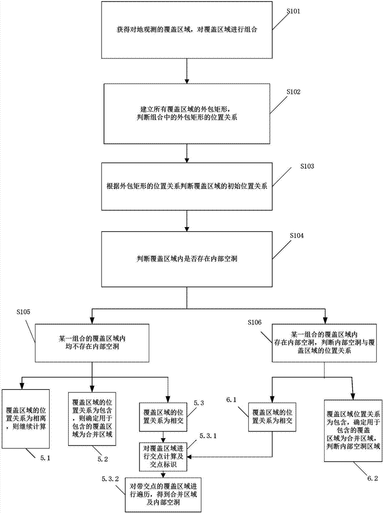
[0038] Please refer to figure 1 and figure 2 , the embodiment of the present invention provides a method for finding and confirming the earth observation coverage area of ​​multi-satellite sensors, comprising the following steps:

[0039] Step S101, obtaining coverage areas of all selected satellite sensors for earth observation, and combining the coverage areas.

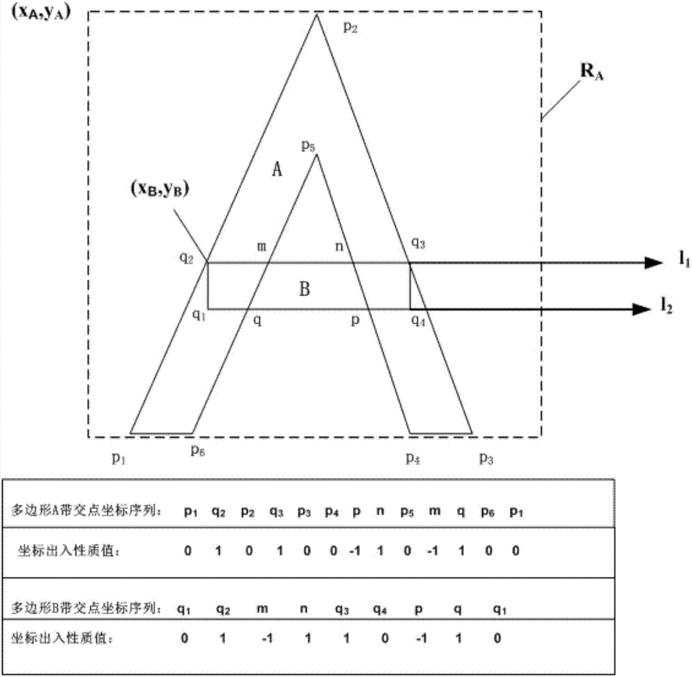
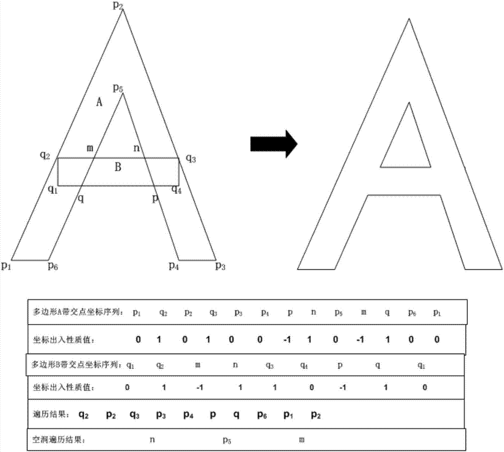
[0040] In one embodiment, the coverage area of ​​each satellite sensor for earth observation is regarded as a polygon, and the coverage areas of all selected n satellite sensors for earth observation are numbered from 1 to n, and the number numbers form a set S ={1,2,...,n}, and then carry out different numbers of combinations on the set S, the number of combinations is Therefore, there w...


PUM


Abstract

A method for merging and confirming the earth observation coverage area of ​​multiple satellite sensors, including the following steps: obtaining the earth observation coverage area of ​​the satellite sensor; establishing an outer rectangle of the coverage area, judging the positional relationship of the outer rectangle; judging the initial position of the coverage area Positional relationship; determine whether there are internal holes in the coverage area; when there are no internal holes in the coverage area: if the coverage area is an inclusion relationship, the coverage area used for inclusion is a merged area; if the coverage area is an intersection relationship, proceed Calculate intersection points and mark the identification of intersection points. Through traversal rules, determine the merged area and internal holes; when there are internal holes in the coverage area, determine the positional relationship between the internal holes and the coverage area: if the coverage area has an intersection relationship, calculate the intersection point and mark it. The identification of the intersection points determines the merge area and internal holes through traversal rules; if the coverage area is an inclusion relationship, determine the coverage area used for inclusion as the merge area.

Description

technical field [0001] The invention relates to the field of earth observation by smart earth, in particular to a method for calculating and confirming coverage areas of earth observation by multi-satellite sensors. Background technique [0002] According to scientists' estimates, by 2020, there will be seven trillion wired or wireless sensors in the world, which are organized through the network to meet people's immediate needs. Under the field model of geographic information science, since sensors are ubiquitous, it is believed that any geographical location on the earth has the need to be observed, and there is a continuous observation capability information field on the entire earth surface, which needs to be discovered to meet the requirements. The sensor is used for observation, and the observation ability of the sensor is an important basis for sensor mining. The observation space range is an important part of the sensor observation capability. There are different ty...

Claims


Application Information

Patent Timeline
Patent Type & Authority Patents(China)
IPC IPC(8): H04W16/18H04B7/185
CPCH04B7/18519H04W16/18
Inventor 胡楚丽黎杰王珂陈能成
Owner 武汉中地大智慧城市研究院有限公司
Features
  • R&D
  • Intellectual Property
  • Life Sciences
  • Materials
  • Tech Scout
  • Unparalleled Data Quality
  • Higher Quality Content
  • 60% Fewer Hallucinations
Learn More