Method and system for reducing road blocking coefficient to improve road traffic capacity

A technology of road capacity and coefficient, which is applied in the direction of road vehicle traffic control system, traffic control system, traffic flow detection, etc. capacity, the effect of reducing the road obstruction coefficient

Inactive Publication Date: 2017-09-05
北京博研智通科技有限公司
View PDF7 Cites 2 Cited by
  • Summary
  • Abstract
  • Description
  • Claims
  • Application Information

AI Technical Summary

Problems solved by technology

However, there are three main problems in the current congestion index calculation method: one is to select several road traffic data of a city to represent all the road data of the city, that is, to use the data obtained by sampling mode to replace the entire road traffic data; Therefore, it cannot fully reflect the accurate traffic conditions of a city as a whole or a road; the second is to compare the average speed of the road with the average speed of the current road and calculate the ratio, that is, the index. The more congested the road network is, the calculation method is one-sided; the third is that the index cannot directly guide the traffic police to eliminate the congestion in the bud or reduce the duration of the congestion, that is to say, it cannot guide the traffic police to quickly find the source of the congestion and eliminate the source of the congestion. budding state to ease road traffic congestion

Method used


Image

  • Method and system for reducing road blocking coefficient to improve road traffic capacity
  • Method and system for reducing road blocking coefficient to improve road traffic capacity
  • Method and system for reducing road blocking coefficient to improve road traffic capacity

Examples


Embodiment 1

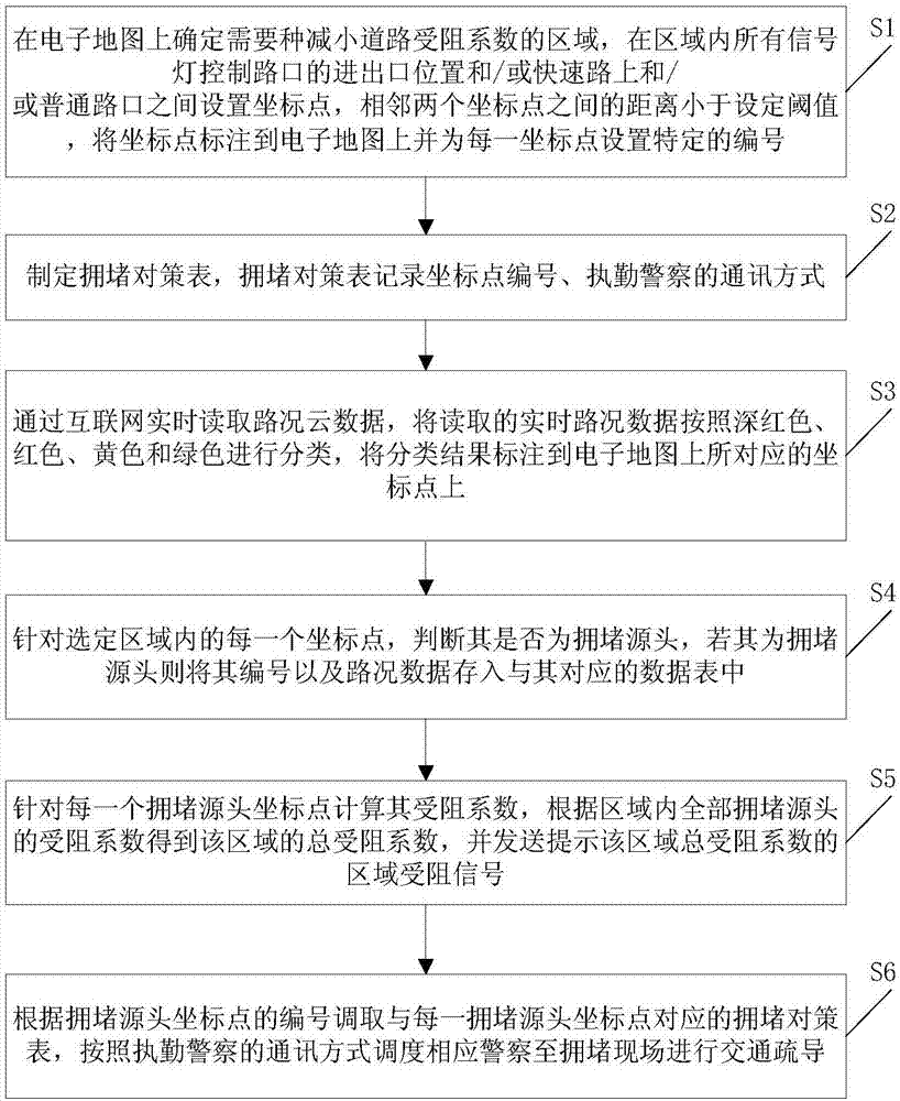
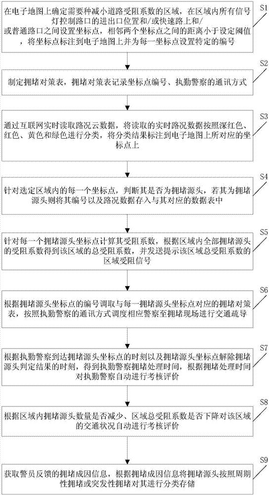
[0065] This embodiment provides a method for reducing the road obstruction coefficient to improve road traffic capacity, such as figure 1 shown, including the following steps:

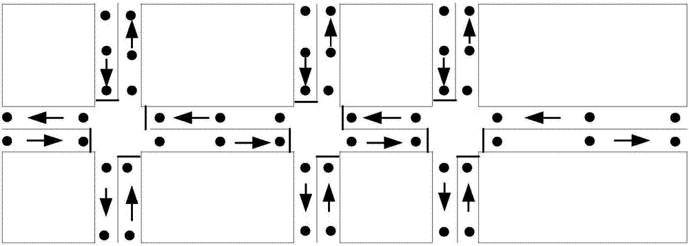
[0066] S1: Determine the area on the electronic map that needs to reduce the road obstruction coefficient, and set coordinate points at the entrance and exit positions of all signal light control intersections in the area and / or between expressways and / or ordinary intersections, with two adjacent coordinate points The distance between them is less than the set threshold, mark the coordinate points on the electronic map and set a specific number for each coordinate point; for example figure 2 As shown, the electronic map is a standard electronic map of the area that needs to calculate the resistance coefficient. Mark the coordinate points on the electronic map, and the actual distance between two adjacent coordinate points can be set between 100 meters and 150 meters. The coordinate points can be set...

Embodiment 2

[0082] On the basis of Embodiment 1, this embodiment provides a method for judging whether a coordinate point is the source of congestion, such as Figure 4 shown, including the following steps:

[0083] S41: Determine whether the coordinate point of a certain number is dark red, if so, execute step S42, otherwise execute step S43;

[0084] S42: Determine whether the coordinate point immediately downstream of the numbered coordinate point is dark red, if not, execute step S47, and if so, return to step S3;

[0085] S43: Determine whether the numbered coordinate point is red, if so, execute step S44, otherwise execute step S45;

[0086] S44: Determine whether the coordinate point immediately downstream of the numbered coordinate point is dark red or red, if not, execute step S47, and if so, return to step S3;

[0087] S45: Determine whether the numbered coordinate point is yellow, if so, execute step S46, otherwise return to step S3;

[0088] S46: Determine whether the coordin...

Embodiment 3

[0101] This embodiment provides a system for reducing road obstruction coefficient to improve road traffic capacity, such as Figure 6 shown, including:

[0102] Electronic map labeling module 1, determine the area that needs to reduce the road obstruction coefficient on the electronic map, set coordinate points between the entrance and exit positions of all signal light control intersections in the area and / or between expressways and / or ordinary intersections, two adjacent If the distance between two coordinate points is less than the set threshold, mark the coordinate points on the electronic map and set a specific number for each coordinate point; mark the coordinate points on the electronic map, the actual distance between two adjacent coordinate points can be Set between 100m and 150m. The coordinate points can be set at any position, preferably at the entrance and exit of the intersection, and the arrows in the figure indicate the driving direction. For the electronic ...


PUM


Abstract

The invention provides a method and system for reducing the road blocking coefficient to improve the road traffic capacity. According to the invention, a city road is divided into a plurality of coordinate points, the distance between adjacent coordinate points is less than a set threshold, a congestion countermeasure table is formulated for each coordinate point, and the coordinate points and the corresponding congestion countermeasure tables are associated through coordinate point serial numbers. In allusion to each coordinate point, road condition data of the coordinate point can be read in real time through the Internet. Whether a coordinate point is a congestion source or not can be judged according to the road condition data of each coordinate point and road condition data of a downstream coordinate point adjacent to the coordinate point, and if the coordinate point is determined to be a congestion source, the blocking coefficient of the congestion source is acquired according to the difference between the road condition data of the coordinate point and the road condition data of the adjacent downstream coordinate point. When a certain coordinate point becomes the congestion source, a congestion countermeasure table corresponding to the coordinate point can be searched according to the coordinate point serial number, the police is dispatched to get to the scene of the congestion source to perform traffic dispersion, and the congestion source is eliminated in the bud or the duration of the congestion source is shortened.

Description

technical field [0001] The invention relates to the field of road traffic management, in particular to a method and system for reducing road obstruction coefficient to improve road traffic capacity. Background technique [0002] Road traffic congestion continues to spread from megacities to small and medium-sized cities, which has attracted the attention of governments at all levels. Both the decision-making department and the management department of a city want to provide travelers with a safe, convenient, fast and punctual traffic environment through various means. [0003] Large companies using Internet + traffic guidance technology have invented various congestion index calculation methods after obtaining large-scale road congestion status in major cities across the country. They want to use this information to provide travel advice for travelers and guide them not to go to places with high congestion indexes At the same time, I want to use these indexes to provide man...

Claims


Application Information

Patent Timeline
Patent Type & Authority Applications(China)
IPC IPC(8): G08G1/01
CPCG08G1/0145
Inventor 姜廷顺朱朝晖李萌隽海民贾胜勇邱红桐潘汉中戴帅石永辉邹平王军利王家捷侯文宇尹胜超
Owner 北京博研智通科技有限公司
Why Eureka
Try Eureka