Route planning method and device

A path planning and path technology, which is applied to measurement devices, road network navigators, instruments, etc., can solve the problem of large amount of calculation in path planning, and achieve the effect of improving the efficiency of path planning and reducing the amount of calculation.

Active Publication Date: 2017-09-15
ALIBABA (CHINA) CO LTD
View PDF4 Cites 13 Cited by
  • Summary
  • Abstract
  • Description
  • Claims
  • Application Information

AI Technical Summary

Problems solved by technology

Although the algorithm of path planning is being continuously optimized, the calculation amount of path planning is still relatively l

Method used


Image

  • Route planning method and device
  • Route planning method and device
  • Route planning method and device

Examples


Embodiment 1

[0026] Embodiment 1, a path planning method.

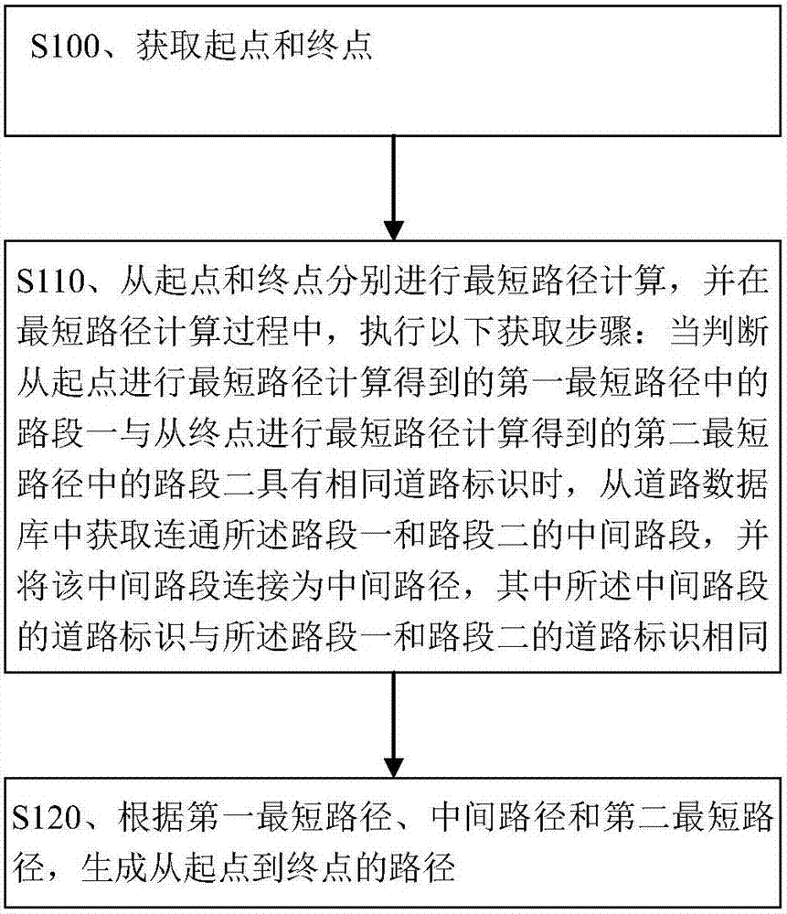
[0027] figure 1 This is a flowchart of the path planning method of this embodiment. like figure 1 As shown, the method of this embodiment mainly includes: step S100, step S110 and step S120. The method described in this embodiment may be executed on the intelligent electronic device on the network side or on the intelligent electronic device on the user side. For example, in the process of implementing online route planning or online navigation, the method described in this embodiment The path planning method may be executed by a server (such as a cloud server) on the network side; for another example, in the process of implementing offline path planning or offline navigation, the path planning method described in this embodiment may be implemented by a smart mobile phone, tablet, etc. on the user side. Executed by a user device such as a computer or a computer. This embodiment does not limit the specific representation form o...

Embodiment 2

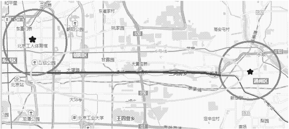
[0055] Embodiment 2, a path planning method. Combine below figure 2 The method of this embodiment will be described.

[0056] In this embodiment, it is assumed that the information of the integrated road of the Jingtong Expressway up / down is pre-stored, and the integrated road information includes the name of the Jingtong Expressway, the IDs of all road sections included in the Jingtong Expressway's upward road, and the Index information, ID and index information (including index value) of all road segments included in the down road of Jingtong Expressway. The segments on the integrated road are consecutive according to the driving direction and their corresponding index values ​​are sequentially sorted in ascending order or descending order. If the integrated road includes road segment 1, road segment 2, road segment 3, road segment 4, ..., and road segment n in sequence according to the driving direction, the corresponding index values ​​are 1, 2, 3, ..., n in sequence. ...

Embodiment 3

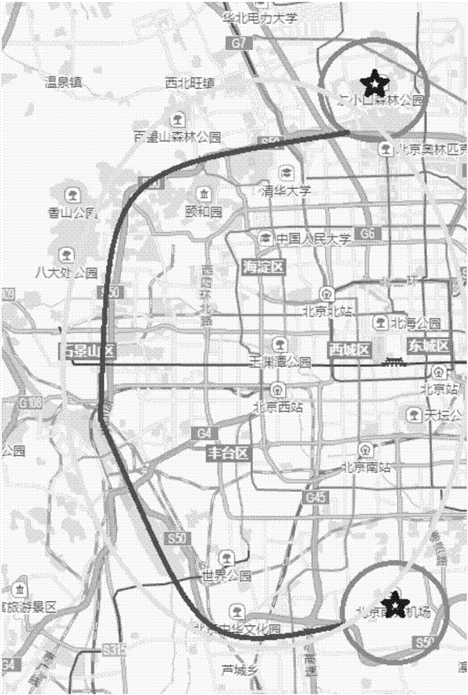
[0060] Embodiment 3, a path planning method. Combine below image 3 The method of this embodiment will be described.

[0061] In this embodiment, it is assumed that the information of the integrated road of Beijing 5th Ring Road up / down is pre-stored, and the integrated road information includes the name of Beijing 5th Ring Road and the information of all road sections included in the up road of the 5th Ring Road in Beijing. ID and index information, ID and index information (including index values) of all road segments included in the downlink road of the Fifth Ring Road, etc.

[0062] When the shortest path calculation with priority of urban expressway is required, the starting point and the end point of this shortest path calculation are set as image 3 For example, the starting point is Beijing Dongxiaokou Forest Park and the end point is Beijing Nanyuan Airport. First, in this embodiment, the shortest path should be calculated from the starting point and the ending poi...


PUM


Abstract

The invention provides a route planning method and device. The method mainly includes the steps: acquiring a starting point and an end point; calculating the shortest routes from the starting point and the end point; generating a route from the starting point to the end point according to a first shortest route, a middle route and a second shortest route. In the calculation process of the shortest routes, when a first road section of the first shortest route obtained by calculating the shortest routes from the starting point and a second road section of the second shortest route obtained by calculating the shortest routes from the end point have the same road signs according to judgment, middle road sections for communicating the first road section with the second road section are acquired from a road database and connected into the middle route, and road signs of the middle road sections are as same as those of the first road section and the second road section. According to the technical scheme, the calculation amount of the shortest routes can be decreased to a greater degree, and route planning efficiency is effectively improved.

Description

technical field [0001] The invention relates to electronic map technology, in particular to a path planning method and a path planning device. Background technique [0002] In electronic map technology, there is often a need to plan a path between a starting point and an ending point. [0003] At present, the implementation principle of a widely used path planning method is: expanding the calculation from the starting point and the ending point at the same time, when the shortest path calculated based on the starting point and the shortest path calculated based on the ending point contain the same road attributes When the same road segment is located, the calculation operation of the shortest path is no longer performed, and the shortest path calculated based on the starting point and the shortest path calculated based on the ending point can be combined to determine the path between the starting point and the ending point. [0004] In the process of realizing the present i...

Claims


Application Information

Patent Timeline
IPC IPC(8): G01C21/34
CPCG01C21/343
Inventor 郭建山
Owner ALIBABA (CHINA) CO LTD
Why Eureka
Try Eureka