A method for identifying geological boundaries and their attribute information in two-dimensional geological cross-section maps

A technology of attribute information and identification method, applied in the field of geological research, can solve the problems of low efficiency, large workload, manual extraction, etc., and achieve the effect of strong controllability, large-scale application requirements and high efficiency

Active Publication Date: 2020-07-14
CHINA RAILWAY DESIGN GRP CO LTD
View PDF5 Cites 0 Cited by
  • Summary
  • Abstract
  • Description
  • Claims
  • Application Information

AI Technical Summary

Problems solved by technology

However, the geological boundaries in the 2D geological section are comprehensively judged by geological engineers combined with drilling information and regional geological conditions. There is no geological boundary data with accurate geological attribute information in the traditional database. When 3D geological modeling needs to manually extract the geological boundaries and Its attribute information, the workload is heavy and the efficiency is low
That is, the traditional technology has the following defects: in the process of 3D geological modeling, it is necessary to make full use of the existing 2D engineering geological data, and there is no geological boundary data with accurate geological attribute information in the traditional database, and the 2D engineering geological data is manually extracted The workload of geological boundaries and their geological attributes in China is heavy and the efficiency is low.

Method used


Image

  • A method for identifying geological boundaries and their attribute information in two-dimensional geological cross-section maps
  • A method for identifying geological boundaries and their attribute information in two-dimensional geological cross-section maps
  • A method for identifying geological boundaries and their attribute information in two-dimensional geological cross-section maps

Examples


Embodiment Construction

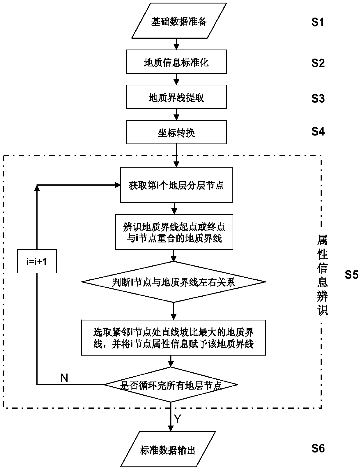
[0039] In order to further understand the content of the invention, features and effects of the present invention, the following examples are given, and detailed descriptions are as follows in conjunction with the accompanying drawings:

[0040] see Figure 1 to Figure 3 , a method for identifying geological boundaries and their attribute information in two-dimensional geological cross-section maps. Based on conventional two-dimensional engineering geological data, the geological boundaries in engineering geological cross-section maps are extracted, and compared with the geological information in the engineering geological backup database, through Comparing the slope ratio of the straight line segment adjacent to the stratum node to determine the attribute of the geological boundary line; including the following steps:

[0041] S1: basic data preparation;

[0042] Engineering geological data: mainly includes engineering geological data backup database, engineering geological ...


PUM


Abstract

The invention discloses a two-dimensional geological sectional-view geological boundary line and an identification method of attribute information and relates to the geological research method technology field. The method comprises the following steps of step101, basic data preparation; step102, geological information standardization; step103, geological boundary line extraction; step104, coordinate conversion; step105, attribute information identification; and step106, standard data output. Through the above technical scheme, conventional two-dimensional engineering geological data is taken as a basis, the geological boundary line in an engineering geological sectional view is extracted, geological information in an engineering geological backup database is compared, and through comparing linear slope ratios of adjacent stratum nodes, an attribute of the geological boundary is determined. The method possesses the following characteristics that man-machine interaction operation is realized; controllability is high; efficiency is high too; a large scale application demand is satisfied; and a solid foundation is laid for three-dimensional geological modeling and a production application.

Description

technical field [0001] The invention relates to the technical field of geological research methods, in particular to a method for identifying geological boundaries and their attribute information in a two-dimensional geological section map. Background technique [0002] Three-dimensional geological modeling is a technology that uses computer technology to combine geological information with visualization tools in a three-dimensional environment for geological research. [0003] Due to the complexity of engineering geological conditions and the limitation of cognition, the methods and technologies of 3D geological modeling are not yet mature. Most of the existing 3D geological modeling methods are based on 2D engineering geological data, such as 2D geological sections, to extract geological boundaries and their attribute information, further deduce and calculate the geological interface, and finally build a 3D geological model. However, the geological boundaries in the 2D ge...

Claims


Application Information

Patent Timeline
Patent Type & Authority Patents(China)
IPC IPC(8): G06T7/60G06T19/20
CPCG06T7/60G06T19/20
Inventor 李红旭张利国陈则连张晨张戎垦
Owner CHINA RAILWAY DESIGN GRP CO LTD
Why Eureka
Try Eureka