
Method for calculating sample plot minimum area of Karst mountain vegetation

A karst and area technology, applied in the field of plant ecology, can solve problems such as inconsistent habitat conditions, increased survey costs, and large area, and achieve the effects of avoiding large errors, good repeatability, and accurate calculations

Inactive Publication Date: 2017-11-28
GUANGXI FORESTRY RES INST
View PDF2 Cites 2 Cited by
  • Summary
  • Abstract
  • Description
  • Claims
  • Application Information

AI Technical Summary

Problems solved by technology

We have found in the survey of karst mountain vegetation in southwestern Guangxi in recent years that the standard land area is too large.
The standard plot is too large, which not only increases the survey cost, but also may cover a variety of communities or a variety of intersecting ecological zones in a standard plot, which does not meet the basic requirements of "consistent distribution of species and components and consistent habitat conditions in the standard plot"

Method used


Image

  • Method for calculating sample plot minimum area of Karst mountain vegetation
  • Method for calculating sample plot minimum area of Karst mountain vegetation
  • Method for calculating sample plot minimum area of Karst mountain vegetation

Examples


Embodiment 1

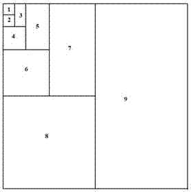
[0044] In November 2015, in the survey of karst mountainous vegetation in Pingzhai Village, Leye, it was first necessary to determine the minimum area of ​​the standard land. In the contiguous 1000m×250m Shishan jujube forest in Pingzhai Village, a representative section with complete community structure and consistent habitat conditions in the middle slope was selected to set up nested quadrats. Starting from the investigation of the number of plant species in a very small quadrat of 0.5m×0.5m, the area was gradually doubled to 16m×16m, and the number of newly added species at each doubling node was recorded as shown in Table 1.

[0045] Table 1: Species-area data of southern wild jujube forest in the karst mountains of Pingzhai Village, Leye

[0046]

[0047]

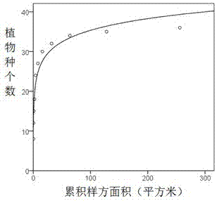
[0048] Taking the cumulative area of ​​nested quadrats in Table 1 as the variable and the number of cumulative species as the dependent variable, SPSS 19.0 was used to fit the species-area logarithmic function c...

Embodiment 2

[0054] In November 2015, in the vegetation survey of Shishan in Yutang Village, Leye, the minimum area of ​​the 18-year-old Rendou plantation standard plot was measured by the nested quadrat area doubling method. On the contiguous 2000m×150m stone hill next to the county road passing through Yutang Village, select representative plots to set up nested quadrats. Starting from a very small sample size of 0.5m×0.5m, the survey area was gradually doubled to 16m×16m, and the number of newly added species and the cumulative number of species at each area doubling node were counted as shown in Table 2.

[0055] Table 2: Species-area data of Rendou forest in karst mountains in Yutang Village, Leye

[0056]

[0057]

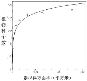
[0058] The species-area logarithmic function of Rendou forest in Yutang village fitted by SPSS is y=11.064+3.423lnx(R 2 =0.98, p image 3 . The area where 90% of the species are observed is about 44.7m 2 . Substituting b=3.423, A=256 and S=28 into the standard gr...

Embodiment 3

[0062] In November 2015, a survey was conducted on the 18-year-old Chinese toon forest in the karst mountains of Longyang Village, Leye. The stone mountain in Longyang Village consists of several peak clusters sitting together at the base to form a larger "lane", and the contiguous condition is poor. Select the hillside with the largest slope in the same orientation for nested quadrat setting, starting from 0.25m 2 The extremely small sample size gradually doubles to 256m 2 . Vegetation species-area survey data are shown in Table 3.

[0063] Table 3: Species-area data of Toona sinensis forest in the karst mountains of Longyang Village, Leye

[0064] Sample number

Cumulative area (m 2 )

The number of new species

Cumulative number of species

1

0.25

7

7

2

0.5

3

10

3

1

2

12

4

2

1

13

5

4

1

14

6

8

4

18

7

16

2

20

8

3...


PUM


Abstract

The present invention discloses a method for calculating the sample plot minimum area of the Karst mountain vegetation. The method is characterized in that: steps such as using the nesting quadrat amplification, collecting statistics of plant species, using the SPSS software to simulate a plant-area logarithm function, carrying out function derivation and the like are carried out to determine the sample plot minimum area of the Karst mountain vegetation. According to the method disclosed by the present invention, by using the sample plot minimum area model, the sample plot minimum area in the Leye Karst mountain vegetation community is calculated to be 28 m2 to 63 m2, which is far from the sample plot minimum area of the forests traditionally used; the method disclosed by the present invention is simple, easy-friendly, and reproducible, is accurate in calculation, and has fewer statistical nodes; and the change range of the descripted area is larger, and without further derivation, the method can be directly used in practice, so that blindly applying the standards of communities such as forests and shrub lands are avoided, large differences due to manual drawings by different persons are avoided, and the method can be promoted and applied to the forests, shrub lands, grass lands and other vegetation types.

Description

technical field [0001] The invention belongs to the field of plant ecology, and relates to a method for determining the minimum area of ​​a vegetation community standard land, in particular to a calculation method for the minimum area of ​​a karst mountain vegetation standard land. Background technique [0002] The standard ground method is the basic method for studying community structure and analyzing species composition. Standard land (relevé) refers to an area set in a lot that can reflect the basic characteristics of plant communities. The area of ​​the standard land should not be smaller than the minimum area of ​​the community. Determining the minimum area of ​​the standard land is an important link in the study of vegetation community composition and biodiversity. In foreign countries, the nested quadrat method (Nested Quadrat) is usually adopted to gradually double the area of ​​the quadrat, and the species-area curve is drawn to determine the minimum standard lan...

Claims


Application Information

Patent Timeline
Patent Type & Authority Applications(China)
IPC IPC(8): G06Q50/02G06F17/50
CPCG06F30/20G06Q50/02
Inventor 黄小荣侯远瑞彭玉华
Owner GUANGXI FORESTRY RES INST
Learn More