Multispectral remote sensing image terrain classification method based on deep and semi-supervised transfer learning

A transfer learning and remote sensing image technology, applied in the field of remote sensing image processing, can solve the problems of inconsistent distribution of training and testing samples, insufficient training samples, etc., and achieve the effect of improving classification accuracy, good classification effect, and preventing deviation.

Inactive Publication Date: 2017-12-08
XIDIAN UNIV
View PDF1 Cites 34 Cited by
  • Summary
  • Abstract
  • Description
  • Claims
  • Application Information

AI Technical Summary

Problems solved by technology

[0006] The technical problem to be solved by the present invention is to provide a multi-spectral remote sensing image classification method based on deep semi-supervised transfer learning to

Method used


Image

  • Multispectral remote sensing image terrain classification method based on deep and semi-supervised transfer learning
  • Multispectral remote sensing image terrain classification method based on deep and semi-supervised transfer learning
  • Multispectral remote sensing image terrain classification method based on deep and semi-supervised transfer learning

Examples


Example Embodiment

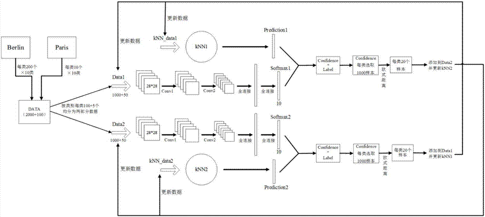
[0057] The present invention provides a multi-spectral remote sensing image feature classification method based on deep semi-supervised migration learning. When training samples are insufficient, a source domain similar to the target domain and unlabeled samples of the target domain are used to assist the classification of target domain data. Specifically: input the multispectral remote sensing image of the training sample, take out the training data set D and kNN data K1 and K2 according to the ground truth; divide the training data set D into two parts, and train two different CNN models CNN1 and CNN2; For classified multi-spectral images, two classification result maps F1 and F2 are obtained in two CNN models; two kNN neighboring algorithm maps are constructed according to training samples K1 and K2, kNN1 and kNN2; F1 and F2 are used to take out the test data A1 and A2, use the kNN proximity algorithm to classify the data; update the classification result graph; update the tr...


PUM


Abstract

The invention discloses a multispectral remote sensing image terrain classification method based on deep and semi-supervised transfer learning. A training data set and kNN data are extracted according to ground truth; the training data set is divided into two parts to be trained respectively; a multispectral image to be classified is inputted, and two classification result images are obtained from two CNN models; two kNN nearest neighbor algorithm images are constructed according to the training samples; the tested data are extracted by using the two classification result images, and the data are classified by using the kNN nearest neighbor algorithm; the classification result images are updated; the training samples and the kNN training samples of cooperative training are updated; and two cooperative training CNN networks are trained again, and the points having the class label of the test data set are classified by using the trained model so that the class of partial pixel points in the test data set is obtained and compared with the real class label. The k nearest neighbor algorithm and the sample similarity are introduced so that deviation of cooperative training can be prevented, the classification accuracy in case of insufficient training samples can be enhanced and thus the method can be used for target recognition.

Description

technical field [0001] The invention belongs to the technical field of remote sensing image processing, and in particular relates to a multispectral remote sensing image ground object classification method based on deep semi-supervised transfer learning, which classifies multispectral images with a small number of marked samples based on pixel levels, and can also be used for target recognition. Background technique [0002] Multispectral remote sensing image is an image obtained by observing the same object (territory or target) in multiple narrow spectral bands at the same time, which reflects the reflection, transmission or radiation characteristics of the observed object in each narrow spectral band, so it includes more information about the observed objects. With the continuous improvement of the quality and quantity of satellite sensors, the classification research theory for multispectral remote sensing images has gradually matured. Compared with traditional remote se...

Claims


Application Information

Patent Timeline
IPC IPC(8): G06K9/62G06N3/04G06N3/08
CPCG06N3/08G06N3/045G06F18/214G06F18/24147
Inventor 焦李成屈嵘程林唐旭张丹陈璞花马文萍侯彪杨淑媛尚荣华
Owner XIDIAN UNIV
Why Eureka
Try Eureka