Space planning model establishing method

A technology of spatial planning and model building, which is applied in the field of land spatial planning, can solve the problem of inability to accurately describe the distribution and changes of planning elements within administrative regions, and achieve the effect of accurate distribution and changes

Pending Publication Date: 2018-02-23
SICHUAN NORMAL UNIVERSITY +1
View PDF3 Cites 16 Cited by
  • Summary
  • Abstract
  • Description
  • Claims
  • Application Information

AI Technical Summary

Problems solved by technology

[0003] Existing spatial planning methods only use the administrative area as the evaluation unit, and can

Method used


Image

  • Space planning model establishing method
  • Space planning model establishing method
  • Space planning model establishing method

Examples


Embodiment Construction

[0015] In order to make the objectives, technical solutions and advantages of the present application clearer, the present application will be further described in detail below with reference to the accompanying drawings and specific embodiments. For simplicity, certain technical features known to those skilled in the art are omitted from the following description.

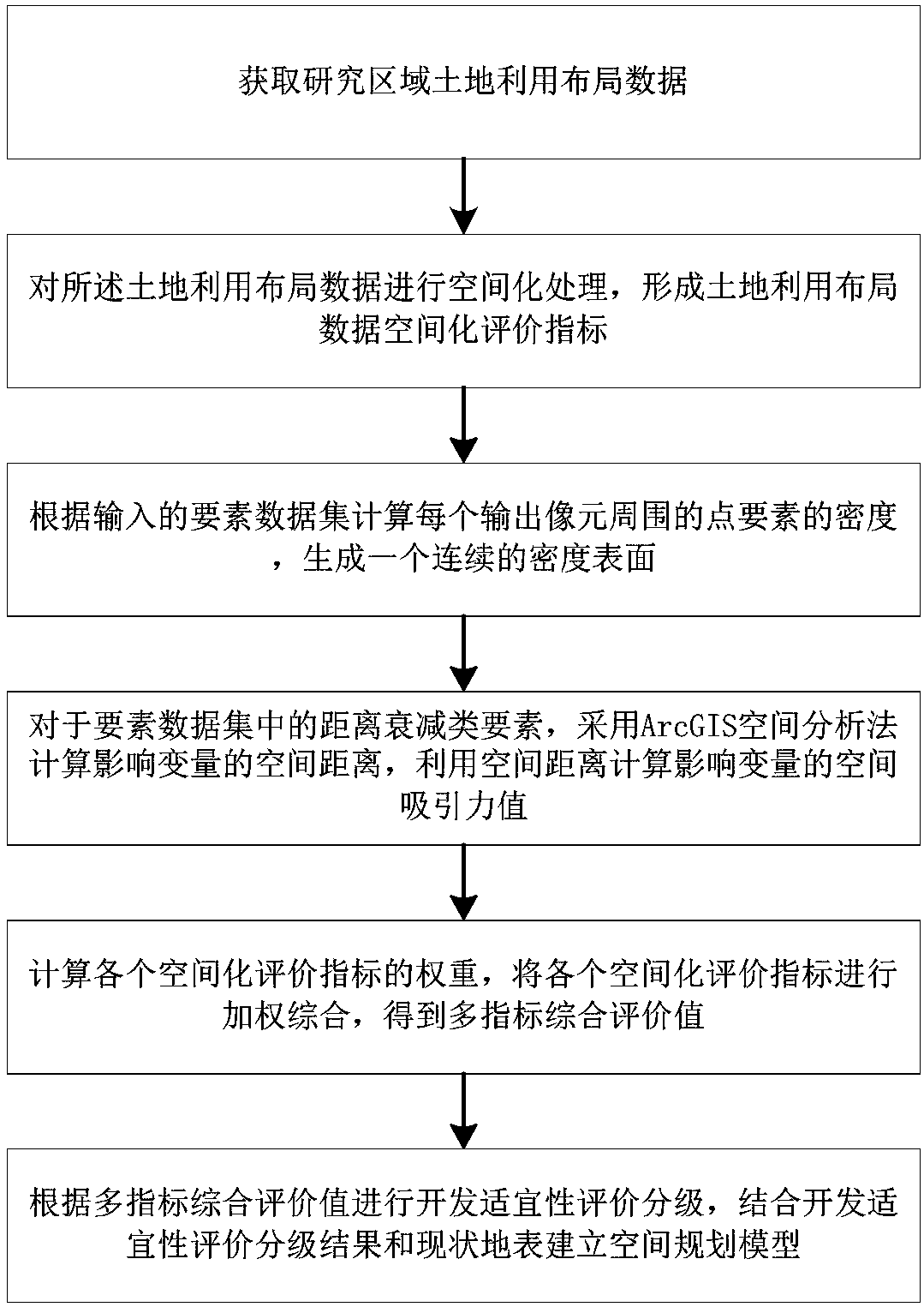
[0016] like figure 1 As shown, this embodiment provides a method for establishing a space planning model, including:

[0017] S1. Obtain land use layout data in the research area, where the land use layout data includes statistical data and spatial data;

[0018] S2. Perform spatial processing on the land use layout data to form a spatial evaluation index of the land use layout data; specifically, it includes:

[0019] S21, making a variable pixel geospatial grid within the research area according to the spatial data;

[0020] S22. Spatially superimpose the variable pixel geospatial grid and the statistical dat...


PUM


Abstract

The invention relates to the land space planning technical field, and specifically relates to a space planning model establishing method comprising the following steps: S1, obtaining research area land utilization layout data; S2, spatializing the land utilization layout data so as to form a land utilization layout data spatialization evaluation index; S3, calculating surrounding point essential factor density of each output pixel according to the inputted data spatialization evaluation index; S4, aiming at distance attenuation type factors in the data spatialization evaluation index, calculating the space distance of affecting variables, and using the space distance to calculate the space attractive force value of the affecting variables; S5, calculating the weight of each spatializationevaluation index, weighting and integrating each spatialization evaluation index so as to obtain the multi-index integrated evaluation value; S6, building the space planning model. The method uses thegeography national condition monitoring results as the basis to build the full spatialization evaluation model, thus improving a conventional evaluation model using administrative areas are the evaluation units, and forming the complete set of space planning model.

Description

technical field [0001] The invention belongs to the technical field of land space planning, in particular to a method for establishing a space planning model. Background technique [0002] The preparation of spatial planning aims to systematically sort out the content and structure of various spatial planning, study the technical path of coordinating the preparation of provincial spatial planning based on the planning of main functional areas, and explore the realization form of "multi-planning into one". In accordance with the planning requirements of national and provincial main functional zones, on the basis of carrying out resource and environmental carrying capacity evaluation, combined with the preliminary research results of provincial spatial planning, accurately determine the spatial scope of urban, agricultural and ecological categories, as well as urban development boundaries, permanent basic farmland, Ecological protection red line, scientifically draw the provin...

Claims


Application Information

Patent Timeline
IPC IPC(8): G06Q10/06G06Q50/26
CPCG06Q10/063G06Q50/26
Inventor 辜寄蓉倪文辉张志强江浏光艳马炅妤李炫朱磊吴修月
Owner SICHUAN NORMAL UNIVERSITY
Why Eureka
Try Eureka