
Dynamic measurable real scene map creation method

A technology of a real map and a production method, applied in the field of measurable real scenes, can solve the problems of poor accuracy, error-prone points, lack of timeliness, etc., and achieve the effect of enhancing timeliness and improving accuracy

Active Publication Date: 2018-05-04
江苏省测绘研究所
View PDF7 Cites 19 Cited by
  • Summary
  • Abstract
  • Description
  • Claims
  • Application Information

AI Technical Summary

Problems solved by technology

[0006] 1. When constructing a depth map of low-density point clouds, the foreground objects cannot block the background objects, causing the scene clouds in the same area to be mixed in the same area. Wrong location coordinates
[0007] 2. There are a large number of null pixels on the surface of the depth map constructed by low-density point cloud. When obtaining coordinates, the coordinates of a certain non-null pixel in the surrounding area are often obtained according to an appropriate threshold, which causes the accuracy to deteriorate.
[0008] The traditional measurable real scene is not time-sensitive due to the lack of a dynamic update scene mechanism; when integrating and expressing video files and electronic map two-dimensional vector services that require high timeliness, an isolated processing method is adopted, only based on geographical coordinates Do association instead of integrated expression in the same 3D space. There are video files placed in a non-real 3D space with a fixed viewing angle. When the scene moves and rotates, it is prone to deformation, position offset, or relying on artificially designated real space to place the plane , the problem of pre-fixing the video position through static configuration files; the problem that the vector service cannot be directly loaded in the real space; when picking up the real map position, the existing depth map method directly calculates the point cloud projection calculation, and there are a large number of null values ​​​​on the surface of the object Pixels and front and rear scenic spot clouds are mixed, so that the accuracy is poor when obtaining coordinates, and even the wrong position coordinates are obtained

Method used


Image

  • Dynamic measurable real scene map creation method

Examples


Embodiment Construction

[0021] In order to make the purpose and technical solutions of the embodiments of the present invention more clear, the technical solutions of the embodiments of the present invention will be clearly and completely described below in conjunction with the drawings of the embodiments of the present invention. Apparently, the described embodiments are some, not all, embodiments of the present invention. Based on the described embodiments of the present invention, all other embodiments obtained by persons of ordinary skill in the art without creative efforts shall fall within the protection scope of the present invention.

[0022] Those skilled in the art can understand that, unless otherwise defined, all terms (including technical terms and scientific terms) used herein have the same meaning as commonly understood by those of ordinary skill in the art to which this invention belongs. It should also be understood that terms such as those defined in commonly used dictionaries shoul...


PUM


Abstract

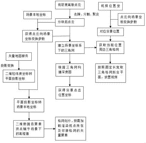
The invention discloses a dynamic measurable real scene map creation method. According to the method, low-density discrete point cloud data within a designated range in a viewpoint range is acquired;point cloud data noise removal is performed according to a point cloud data adjacent relation; a partitioning plane where the point cloud data is divided is calculated; the point cloud data is saved in blocks; a triangular network is established; a depth map is constructed; real scene click position coordinates are obtained; the position of video data in a measurable real scene is calculated; a triangular network within a preset range around the position of the video data is acquired; a plane with fixed length and width is fitted to server as a placement plane of the video data; elevation values of corresponding positions in a three-dimensional scene are given to all element coordinates of two-dimensional plane data; and an on-demand loading strategy is adopted during scene vector elementrendering. Through the method, the problem that a wrong position is prone to be acquired when the position coordinates are acquired through the depth map created based on point cloud is solved, and meanwhile the precision of the click acquisition position in the low-density point cloud is improved through plane structure characteristics.

Description

technical field [0001] The invention belongs to the measurable real-scene field in the field of surveying and mapping geographic information, and in particular relates to a method for making a dynamic measurable real-scene map. Background technique [0002] Street View uses panoramic cameras and positioning equipment to record the real-world image information of the location sequence, and the user can only get the visual model of the given location and the rough spatial model based on a limited number of positioning points. [0003] The measurable real-scene image is based on the basic display principle of street view, and at the same time collects three-dimensional surface position information along the line through vehicle-mounted or ship-borne mobile measurement technology. It has a relatively complete geospatial model and is a real-scene image expression in three-dimensional space. [0004] The traditional measurable real scene only introduces the concept of measurable o...

Claims


Application Information

Patent Timeline
Patent Type & Authority Applications(China)
IPC IPC(8): G06T17/05G06T17/20G06T5/00G06F17/30
CPCG06F16/29G06T17/05G06T17/20G06T2207/20021G06T2207/10016G06T2207/10028G06T5/70
Inventor 吕志慧邱天赫春晓朱周华李真徐偲唐权倪冰洁
Owner 江苏省测绘研究所
Learn More