Unlock instant, AI-driven research and patent intelligence for your innovation.

Method and device for checking spatial data

A space data and space inspection technology, applied in the computer field, can solve problems such as inability to accurately check space data errors, error expansion, etc.

Inactive Publication Date: 2018-05-18
INSPUR QILU SOFTWARE IND
View PDF2 Cites 1 Cited by
  • Summary
  • Abstract
  • Description
  • Claims
  • Application Information

AI Technical Summary

Problems solved by technology

[0003] At present, the spatial data is mainly inspected by manual inspection. The manual inspection method has errors due to the high degree of manual intervention, and when the data

Method used


Image

  • Method and device for checking spatial data
  • Method and device for checking spatial data
  • Method and device for checking spatial data

Examples


Embodiment Construction

[0049] In order to make the purpose, technical solutions and advantages of the embodiments of the present invention clearer, the technical solutions in the embodiments of the present invention will be clearly and completely described below in conjunction with the drawings in the embodiments of the present invention. Obviously, the described embodiments It is a part of the embodiments of the present invention, but not all of them. Based on the embodiments of the present invention, all other embodiments obtained by those of ordinary skill in the art without creative work belong to the protection of the present invention. scope.

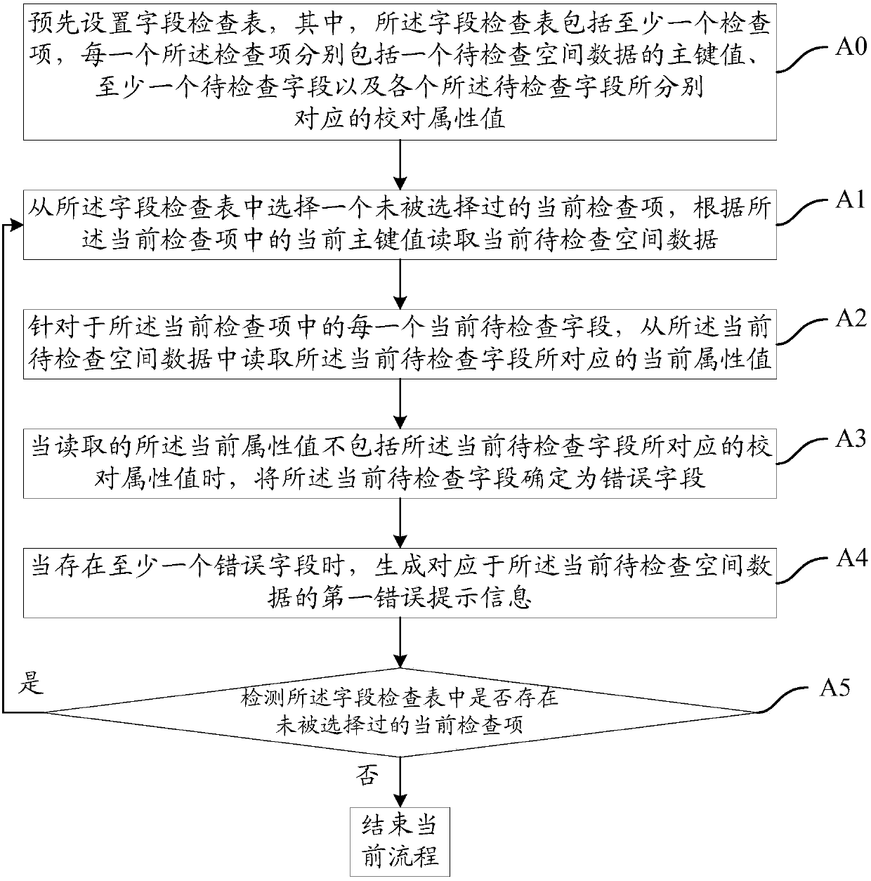
[0050] Such as figure 1As shown, the embodiment of the present invention provides a method for checking spatial data, including:

[0051] A0: Preset the field check table, wherein the field check table includes at least one check item, and each check item includes a primary key value of the spatial data to be checked, at least one field to be checked, ...


PUM


Abstract

The invention provides a method and a device for checking spatial data. The method comprises the following steps that: A0: presetting a field check list; A1: selecting a current check item which is not selected from the field check list, and reading current check spatial data according to a current major key value in the current check item; A2: aiming at each current field to be checked in the current check item to read a corresponding current attribute value from the current spatial data to be checked; A3: when the read current attribute value does not contain a proofreading attribute value corresponding to the current field to be checked, determining the current field to be checked as a wrong field; A4: when the wrong field is in the presence, generating first error prompt information corresponding to the current spatial data to be checked; and A5: detecting whether the field check list contains the current check item which is not selected, and executing A1 when the current check list which is not selected. Through the technical scheme of the invention, whether the spatial data contains errors or not can be accurately detected.

Description

technical field [0001] The invention relates to the field of computer technology, in particular to a method and device for checking spatial data. Background technique [0002] During the warehousing process of land data, it is necessary to check the quality of each spatial data (including two-dimensional data or three-dimensional data with multiple fields), mainly for the attribute value of the specified field in the spatial data. When it is checked that the attribute value does not match the check value, it can be determined that there is an error in the corresponding spatial data. [0003] At present, the spatial data is mainly inspected by manual inspection. The manual inspection method has errors due to the high degree of manual intervention, and when the data volume of the inspected spatial data is larger, the error will be enlarged accordingly. As a result, it is impossible to accurately check whether there is an error in the spatial data. Contents of the invention ...

Claims


Application Information

Patent Timeline
IPC IPC(8): G06F11/07G06F17/30
CPCG06F11/0727G06F16/215G06F16/2282
Inventor 郭振陈宇浩
Owner INSPUR QILU SOFTWARE IND