Map labeling method, device, cloud end server, terminal and application program

A cloud server and map technology, applied in the field of map labeling, can solve the problems of high labor cost and low efficiency, and achieve the effect of improving efficiency

Pending Publication Date: 2018-06-05
CLOUDMINDS SHANGHAI ROBOTICS CO LTD
View PDF7 Cites 5 Cited by
  • Summary
  • Abstract
  • Description
  • Claims
  • Application Information

AI Technical Summary

Problems solved by technology

[0004] At present, the scheme of manual map labeling must be carried out on the basis of

Method used


Image

  • Map labeling method, device, cloud end server, terminal and application program
  • Map labeling method, device, cloud end server, terminal and application program
  • Map labeling method, device, cloud end server, terminal and application program

Examples


Embodiment 1

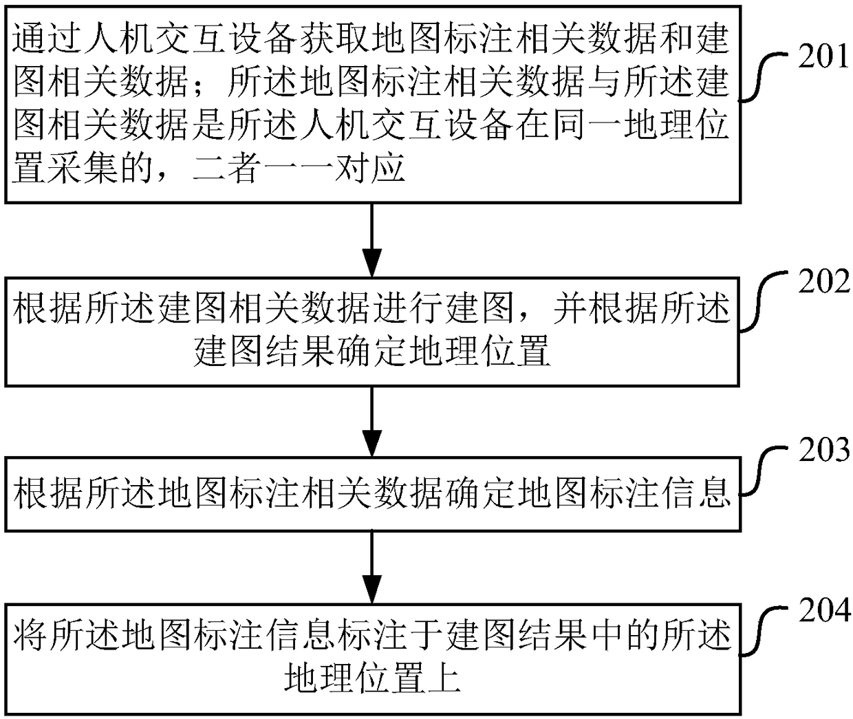
[0103] Figure 7 An embodiment of the method for map labeling provided in the embodiment of this application Figure 1 ,Such as Figure 7 As shown, the devices involved in data collection include: human-computer interaction devices (including at least cameras), and other sensor modules. Human-computer interaction devices may include: keyboards, mice, touch screens, image or video interaction devices, or voice interaction devices, etc. Human-computer interaction devices collect instructions from people and process and identify them as information that is manually input into road signs. For example, when the human-computer interaction device is a microphone, the microphone collects the voice information "here is a supermarket" from the user, that is, the manual input of road signs is realized, and the road sign information marking the location is "supermarket".

[0104] And the camera can have two functions. 1. Collect images of road sign information such as "supermarket" or ...

Embodiment 2

[0111] Figure 8 An embodiment of the method for map labeling provided in the embodiment of this application Figure II , assuming that the terminal is a cloud guide helmet. Such as Figure 8 As shown, the cloud-based blind guide helmet may include a camera, a microphone module and a transmitter module, and the transmitter sends the collected image data for map building or map labeling and voice signals for map labeling to the cloud server. The image data and voice data receiving and analysis processing modules are set in the cloud server, and the image data can be sent to the mapping processing module and the map labeling recognition module respectively. The mapping module runs the vSLAM method to build a map and output the motion track, and the recognition module runs Scene understanding outputs automatic road sign information, voice information is recognized and processed to output artificial road sign information, and finally the above road sign information (map annotati...

Embodiment 3

[0113] Figure 9 An embodiment of the method for map labeling provided in the embodiment of this application Figure three , assuming that the map labeling scheme is based on an existing map database. Such as Figure 9 As shown, the map library data is an existing database, such as the map database provided by map manufacturers such as AutoNavi and Baidu. The terminal can include a camera, a microphone module and a GPS positioning module. The terminal sends the image to the recognition module, and the recognition module performs recognition processing on the image and outputs (automatic recognition) road sign information 1 . Perform speech recognition and processing on the voice information collected by the microphone to output (artificial) road sign information 2, GPS locates the current corresponding positions of the above road sign information 1 and 2, and gives corresponding position information on the map. After integrating landmark information 1 and 2, the final map ...


PUM


Abstract

The invention provides a map labeling method, device, cloud end server, terminal and application program. The map labeling method includes receiving map labeling related data and mapping related datafrom the terminal, wherein the map labeling related data and the mapping related data are collected in one geographic position by the terminal and are corresponding to each other; performing mapping according to the mapping related data and determining the geographic position according to the mapping result; determining map labeling information according to the map labeling related data; labelingthe map labeling information on the geographc position in the mapping result. By adopting the technical scheme provided by the invention, synchronous proceeding of mapping and map labeling can be realized through processing of the map labeling related data and mapping related data, and map labeling efficiency can be improved effectively.

Description

technical field [0001] The present application relates to the field of map labeling technology, which can be applied to the field of cloud robots, and in particular to a map labeling method, device, cloud server, terminal and application program. Background technique [0002] A cloud robot is an intelligent robot that puts the cognitive system in the cloud, puts the body, drive, and sensors on the robot body, and connects the two through mobile communication; the cloud robot is the development direction of intelligent humanoid robots. [0003] The map and the information marked on the map for specific locations have brought great convenience to people's daily life and production activities. Map formation with landmark information mainly includes steps such as data collection, off-line mapping processing, and manual verification. At present, map manufacturers including AutoNavi, Baidu, etc. also mostly adopt the scheme of manually labeling maps, that is, manually adding labe...

Claims


Application Information

Patent Timeline
IPC IPC(8): G06F17/30
Inventor 林义闽廉士国
Owner CLOUDMINDS SHANGHAI ROBOTICS CO LTD
Why Eureka
Try Eureka