Cloud-based three-dimensional map generation method, device, equipment and computer-readable storage medium
A three-dimensional map, cloud technology, applied in computing, map/plan/chart, graphics and image conversion, etc., can solve the problems of time-consuming and laborious operation, limited positioning accuracy, etc.
- Summary
- Abstract
- Description
- Claims
- Application Information
AI Technical Summary
Problems solved by technology
Method used
Image

Examples
Embodiment 1
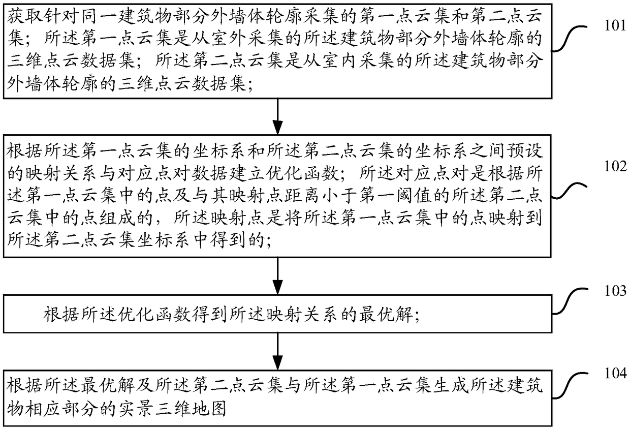
[0072] Figure 6 It is a schematic illustration of an embodiment of the method for generating a three-dimensional map based on the cloud provided in the embodiment of the present invention Figure three ,Such as Figure 6 As shown, when building a map of an indoor scene, the 3D acquisition device performs two tasks while acquiring GPS data: one is to use the RGB camera to collect the picture of the current viewing angle and send it to vSLAM (visual Simultaneous Localization And Mapping, real-time positioning based on vision) Based on the map construction) algorithm scans the indoor space feature points and locates the pose data (Rv, Tv) in real time to generate a SLAM map; the second is based on the calculated pose data (Rv, Tv) and the real-time depth collected by the depth camera Information Depth conducts 3D map modeling in the background through fusion, denoising and other operations to generate indoor 3D point cloud data, which is the first point cloud data mentioned abo...
Embodiment 2
[0077] Figure 7 It is a schematic illustration of an embodiment of the method for generating a three-dimensional map based on the cloud provided in the embodiment of the present invention Figure four ,Such as Figure 7 As shown, the indoor 3D mapping and positioning scheme can be laser radar and RGB camera, the difference is only in the type of equipment used for indoor 3D mapping and positioning, and the specific implementation method steps are the same as in the above-mentioned embodiment 1, here No longer.
[0078] The embodiment of the present invention proposes a method for automatically aligning indoor and outdoor 3D high-precision maps. According to the relocation and mapping relationship of visual mapping algorithms such as SLAM, the high-precision 3D point cloud image is rendered to the current viewing angle in real time, achieving high-precision, real-scene digital browsing
[0079] Those skilled in the art should understand that the embodiments of the present i...
PUM
 Abstract
Description
Claims
Application Information
 - R&D
- Intellectual Property
- Life Sciences
- Materials
- Tech Scout
- Unparalleled Data Quality
- Higher Quality Content
- 60% Fewer Hallucinations
Browse by: Latest US Patents, China's latest patents, Technical Efficacy Thesaurus, Application Domain, Technology Topic, Popular Technical Reports.
© 2025 PatSnap. All rights reserved.Legal|Privacy policy|Modern Slavery Act Transparency Statement|Sitemap|About US| Contact US: help@patsnap.com