Map display method and device

A display method and map technology, which are applied in the directions of maps/plans/charts, instruments, road network navigators, etc., can solve the problems of reducing the intuitiveness and accuracy of electronic maps, unable to directly reflect the three-dimensional geographic reality of map elements, etc. Effects that improve intuitiveness and accuracy

Active Publication Date: 2018-07-10
城市生活(北京)信息有限公司
View PDF3 Cites 13 Cited by
  • Summary
  • Abstract
  • Description
  • Claims
  • Application Information

AI Technical Summary

Problems solved by technology

However, the existing electronic maps do not include the elevation information of the map elements, and thus cannot intuitively reflect the three-dimensional geographical reality of the map elements, which reduces the intuition and accuracy of the electronic map

Method used


Image

  • Map display method and device
  • Map display method and device
  • Map display method and device

Examples


Embodiment Construction

[0069] The following will clearly and completely describe the technical solutions in the embodiments of the present invention with reference to the accompanying drawings in the embodiments of the present invention. Obviously, the described embodiments are only some, not all, embodiments of the present invention. Based on the embodiments of the present invention, all other embodiments obtained by persons of ordinary skill in the art without making creative efforts belong to the protection scope of the present invention.

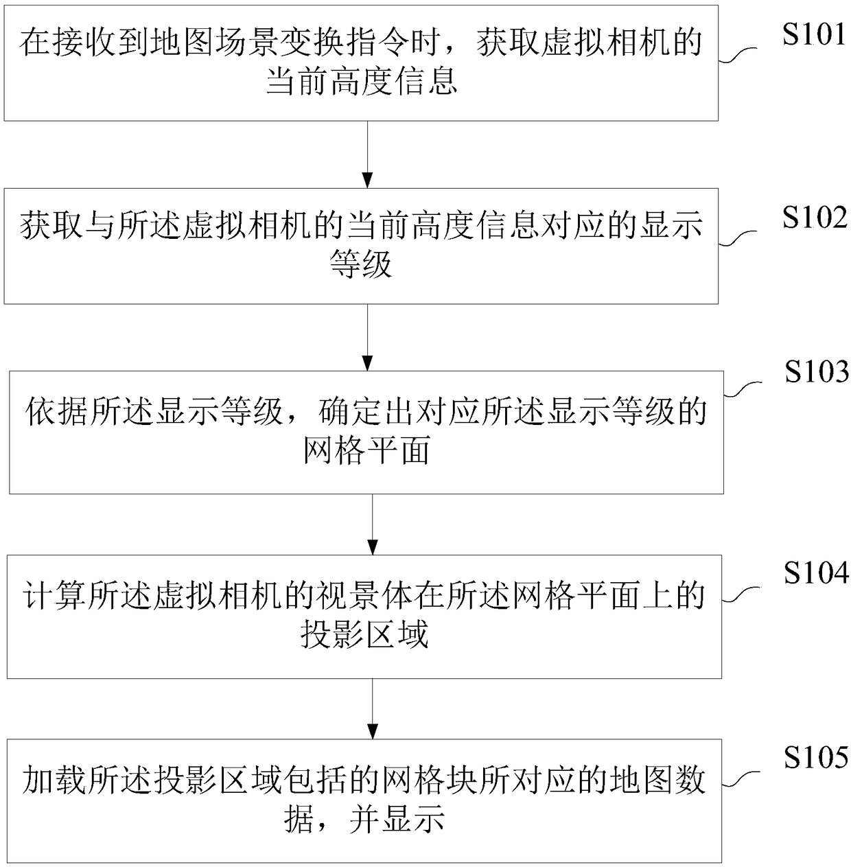
[0070] The embodiment of the present invention discloses a map display method, please refer to the attached figure 1 , the method specifically includes the following steps:

[0071] S101: Obtain the current height information of the virtual camera when receiving the map scene change instruction;

[0072] Specifically, the map scene change instruction may be automatically generated due to a change in the location information of the electronic map. Wherein, th...


PUM


Abstract

The invention provides a map display method and device. By means of a grid plane determined according to the display level, the projection area of a virtual camera's view frustum intersecting with thegrid plane thereon can be calculated, and then when the map data corresponding to the grid blocks in the projection area are loaded and displayed, correct display of map data containing complete elevation information can be guaranteed, a 3D geographic scene corresponding to the map element can be accurately displayed to a user on an electronic map, and the visuality and accuracy of the electronicmap can be improved.

Description

technical field [0001] The present invention relates to the technical field of electronic maps, and more specifically, to a map display method and device. Background technique [0002] With the development of network technology, satellite technology and various surveying and mapping technologies, electronic maps have emerged as the times require. [0003] At present, electronic maps mainly display map elements to users in a flat format similar to traditional paper maps. Its working principle is to determine the display level corresponding to the height information based on the height information of the virtual camera, and then calculate the display level. The intersection area of ​​the corresponding grid plane and the viewing volume of the virtual camera, and display the grid blocks in the intersection area to the user. However, the existing electronic maps do not include the elevation information of the map elements, and thus cannot intuitively reflect the three-dimensiona...

Claims


Application Information

Patent Timeline
Patent Type & Authority Applications(China)
IPC IPC(8): G01C21/36G09B29/00
CPCG01C21/36G09B29/007
Inventor 马延朋
Owner 城市生活(北京)信息有限公司
Why Eureka
Try Eureka