Video GIS data retrieval method based on deep learning

A technology of data retrieval and deep learning, which is applied in the field of computer vision, can solve the problems of poor expression of underlying features of video GIS images, difficulty in obtaining accurate retrieval results, and large storage space consumption, so as to meet retrieval requirements and reduce memory. The effect that takes up, speed of the search

Inactive Publication Date: 2018-07-13
NANJING UNIV OF POSTS & TELECOMM
View PDF3 Cites 25 Cited by
  • Summary
  • Abstract
  • Description
  • Claims
  • Application Information

AI Technical Summary

Problems solved by technology

[0007] Purpose of the invention: In order to overcome the deficiencies in the prior art, the present invention provides a video GIS data retrieval method based on deep learning to solve the problem of difficulty in obtaining accurate retrieval results, large storage space consumption, and slow retrieval speed in video GIS data retrieval. The problem
[0008] To realize the content of the above invention, several core issues must be solved: (1) for the problem of repeated and redundant video GIS frames in the video GIS library, design an efficient key frame extraction method; (2) for the existing For the problem that the low-level feature expression ability of video GIS image is not strong in the technology, the deep learning method is used to realize the feature extraction algorithm based on the deep convolutional neural network; (3) Aiming at the problem of retrieval speed, a video GIS for layered retrieval is designed The data retrieval method meets the retrieval requirements of large-scale video GIS data in terms of retrieval speed and accuracy

Method used


Image

  • Video GIS data retrieval method based on deep learning
  • Video GIS data retrieval method based on deep learning
  • Video GIS data retrieval method based on deep learning

Examples


Embodiment Construction

[0053] The present invention will be further described below in conjunction with the accompanying drawings.

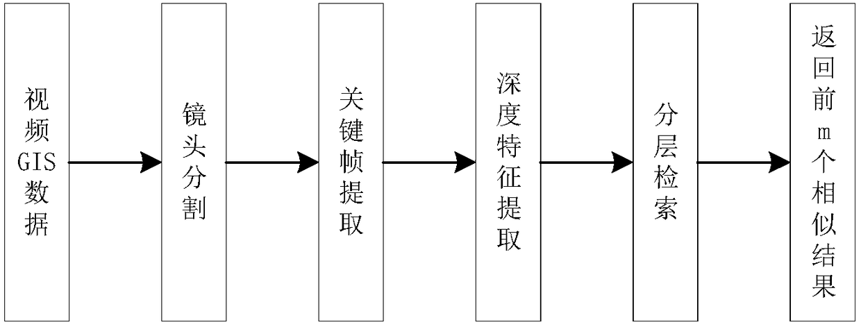
[0054] Such as figure 1 Shown is a video GIS data retrieval method based on deep learning, which mainly includes the following steps:

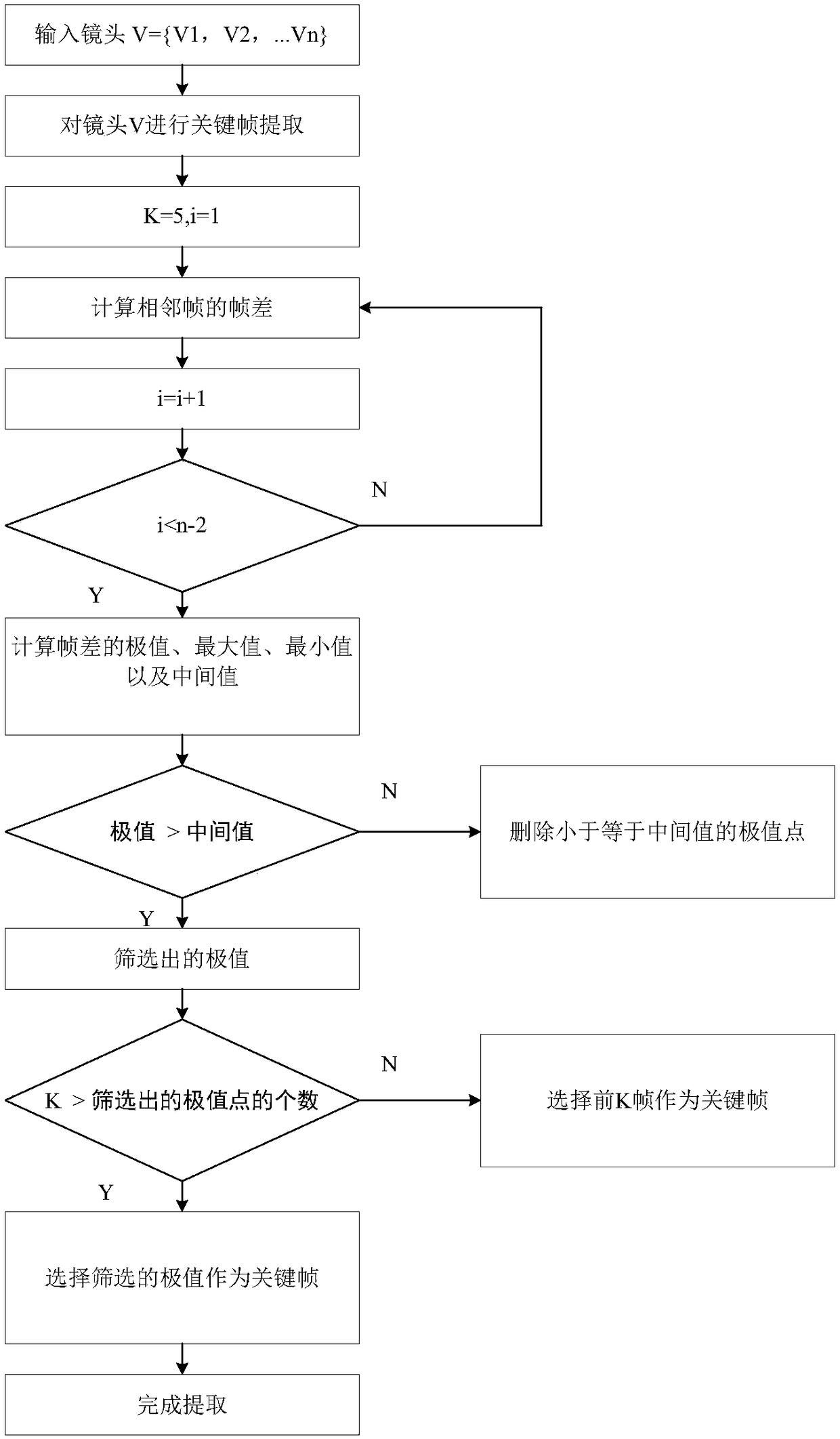
[0055] a. Keyframe extraction

[0056] For video GIS data, there are a lot of repetitive and redundant information in video GIS data. If it is not preprocessed, the video GIS data volume will be quite large, and the retrieval efficiency will be greatly reduced. For example, there may be still pictures in the video GIS data, and if each frame of the video is extracted, there will be repeated or redundant video GIS frames. Therefore, first of all, we need to preprocess the video GIS data, segment the shot, and select valuable information to represent the main content of the video shot, that is, the key frame.

[0057] Simultaneously, since the video GIS data is high-definition data, the key frame pixels are relatively high, resulting ...


PUM


Abstract

The invention discloses a video GIS data retrieval method based on deep learning. The video GIS data retrieval method comprises the steps of firstly, calculating Euclidean distance of a video GIS frame-frame difference under space and time sampling of video GIS data and conducting key frame extracting on a video lens; then building a deep convolutional neural network model alternatively constituted by a convolutional layer, an activating layer and a pooling layer, conducting layer-layer mapping on input video GIS frame images and achieving deep characteristic representing of the video GIS frame images; finally, conducting layered retrieval, wherein in the first layer, a Hash method and Hamming distance are subjected to coarse retrieval, in the second layer, the result of the coarse retrieval in the first layer is filtered, and the first m video GIS frame images are subjected to fine retrieval from a candidate pool. The frame difference Euclidean distance is adopted to extract key frames, so that the retrieval efficiency is greatly improved, the deep convolutional neural network model is adopted for training, characteristic representing of a higher layer is extracted, so that the retrieval time is shortened by a large margin, and storage expenditure is reduced by a large margin.

Description

technical field [0001] The invention relates to a video GIS (Geographic Information System, geographic information system) data retrieval method based on deep learning, which belongs to the technical field of computer vision. Background technique [0002] Video GIS is a new kind of video produced by the fusion of geographic video and GIS. The retrieval of this video has brought great convenience to government management and people's life. With the continuous enhancement of application breadth and depth, video GIS-related industries have become a new industry growth point. At the same time, with the development of smart city construction and the improvement of urban security requirements, how to accurately discover and obtain the data required by users from video GIS big data faces a series of bottleneck problems. On the one hand, we have accumulated a huge amount of video GIS data, and continue to invest heavily in data production. On the other hand, a large amount of video...

Claims


Application Information

Patent Timeline
Patent Type & Authority Applications(China)
IPC IPC(8): G06F17/30G06N3/04G06N3/08
CPCG06F16/735G06F16/783G06N3/08G06N3/045
Inventor 邹志强戴海宏吴家皋何旭熊俊杰索玉聪
Owner NANJING UNIV OF POSTS & TELECOMM
Why Eureka
Try Eureka