A road surface detection method for expressways based on lane lines

A highway and road surface detection technology, applied in instruments, calculations, character and pattern recognition, etc., can solve the problems of small amount of calculation, poor adaptability, limited use range, etc., to weaken the brightness information, smooth the degree of bending, improve The effect of robustness

Active Publication Date: 2020-12-29
ANHUI AGRICULTURAL UNIVERSITY
View PDF2 Cites 0 Cited by
  • Summary
  • Abstract
  • Description
  • Claims
  • Application Information

AI Technical Summary

Problems solved by technology

[0004] Based on the above ideas, Wang et al. published "Image and Vision computing" in "Image and Vision computing" in 2004. It is assumed that the roads in the monitoring scene are parallel, and the B-snake curve is used to fit the lane line. Compared with the spline Interpolation curve, this method makes the generated curve approach as much as possible instead of passing through the interpolation point, the fitted curve is flexible and smooth but requires multiple Hough transforms, which is not conducive to controlling the calculation amount of the algorithm; Jung et al. in 2005 in "Imageand "Lane Following and Lane Departure Using a Linear-parabolic Model" was published on Vision Computing, which uses sub-regional lane line fitting, the nearby road area uses a linear model to fit the lane line, and the far road area uses a parabolic model to fit Lane lines, but the far and near areas in this algorithm are divided in advance, the adaptability is poor, and the scope of use is limited; Lipski et al published "A Fast and Robust Approach" in "In Proceedings of IEEESouthwest Symposium on Image Analysis and Interpretation" in 2008 to Lane Marking Detection and Lane Tracking》calculate the local histogram of the road surface image, and extract the characteristic information such as the color of the road surface image and the road direction. Shadow coverage and the decrease in the clarity of lane lines will affect the detection results; Lee et al published "Effectivelane detection and tracking method using statistical modeling of color and lane" in "In Proceedings of 4th International Conference on Computer Sciences and Convergence Information Technology" in 2009 edge-orientation"Using lane line color and edge information to obtain road lane line pixels and calculate the histogram of edge information and HSV space color information, use Bayesian criteria to classify each pixel in the image, extract lane line pixels, and Fu transformation for fitting; Kong et al published "General Road Detect" in "IEEE Trans on Image Processing" in 2010 ion from A Signal Image》Use Gabor filtering to calculate the local texture of pixels, obtain edge information, and perform Hough transform to find and locate the road ROI area in the image. Although this method is less affected by noise, it is computationally complex too high
[0005] Among the above methods, the model-based method only needs to solve fewer model parameters, has a small amount of calculation, and has strong robustness to noise, but the accuracy of extracting the road surface area depends on the selection of the model and the solution method. The method of feature extraction is directly related to the selection of road surface features, and the expressway will have curves, and the lane line fitting of the entire picture directly affects the accuracy of left and right lane division in this scene

Method used


Image

  • A road surface detection method for expressways based on lane lines
  • A road surface detection method for expressways based on lane lines
  • A road surface detection method for expressways based on lane lines

Examples


Embodiment Construction

[0062] In order to make the purpose, technical solution and advantages of the invention clearer, the technical solution of the present invention will be further described in detail below through the accompanying drawings and embodiments. However, it should be understood that the specific embodiments described here are only used to explain the technical solution of the present invention, and are not intended to limit the scope of the technical solution of the present invention.

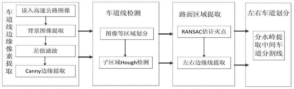
[0063] In order to solve the problems of the prior art, the present invention provides such as figure 1 Example shown.

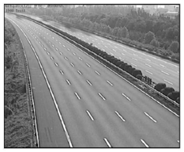
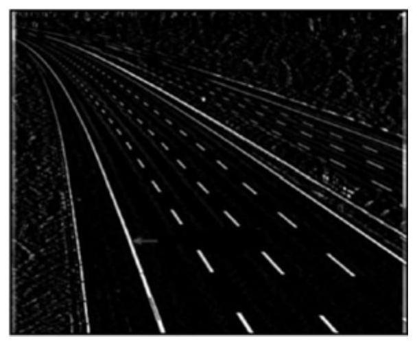
[0064] A lane line-based expressway pavement detection method of the present invention: first extract the edge pixels of the lane line, extract the background image of the highway image of the reading material, then perform difference filtering and then extract the road edge, and then divide the image area Probabilistic Hough detection is performed on each sub-area, and then the lef...


PUM


Abstract

The invention discloses a highway road surface detection method based on lane lines, comprising: continuously collecting at least one video frame image of a video file, and obtaining a target video frame image according to at least one video frame image; Edge detection, to obtain the edge image containing road edge pixels; scan the edge image, obtain the road area, and divide the road area horizontally to obtain sub-areas, and use the probability Hough transform to detect each sub-area to obtain the road edge line segment ; Find the vanishing point according to all the edge segments in the sub-region at the top of the road region, and determine the middle control point of each non-bottom sub-region according to whether there is an intersection point between the straight line with the largest slope and the straight line with the smallest slope in each sub-region, and the final The boundary point of the bottom terminal area; according to the middle control point, boundary point, and vanishing point, draw the edge lines of the left and right lanes. By applying the embodiment of the present invention, the adaptability to the curve scene is improved.

Description

technical field [0001] The invention relates to the field of road surface detection, in particular to a lane line-based expressway road surface detection method. Background technique [0002] Intelligent video surveillance of expressways usually only focuses on the road surface area in the picture, but the surveillance images often contain backgrounds such as sky, trees, buildings, etc., which undoubtedly increases the computational overhead of the monitoring algorithm. At the same time, non-road surface areas are often accompanied by shaking leaves, light These interference factors also affect the accuracy of monitoring. Therefore, it is necessary to extract the highway road surface area in the video image as the preprocessing of video surveillance, filter out the background irrelevant to the road surface, reduce the redundant data in the image, improve the calculation speed, and avoid image information in irrelevant areas from being used for later image processing. interf...

Claims


Application Information

Patent Timeline
Patent Type & Authority Patents(China)
IPC IPC(8): G06K9/32G06K9/46G06K9/00
CPCG06V20/54G06V10/255G06V10/44
Inventor 廖娟朱德泉周平吴敏刘路吴杨张顺
Owner ANHUI AGRICULTURAL UNIVERSITY
Why Eureka
Try Eureka