Multi-scene drone locating mapping method based on three-dimensional laser radar

A three-dimensional laser and unmanned aerial vehicle technology, which is applied in the re-radiation of electromagnetic waves, radio wave measurement systems, and the use of re-radiation. Improve efficiency and solve the effect of indoor and outdoor positioning fusion problems

Active Publication Date: 2018-07-20
江苏中科智能科学技术应用研究院
View PDF5 Cites 62 Cited by
  • Summary
  • Abstract
  • Description
  • Claims
  • Application Information

AI Technical Summary

Problems solved by technology

[0003] Outdoor position information can be obtained by GPS, but positioning in an indoor environment without GPS signals has always been a difficult point. Generally, positioning is performed through complex algorithms. Among them, the SLAM algorithm occupies a dominant position, but the traditional filter-based SLAM algorithm is difficult to adapt to complex large scenes
In addition, one problem that has to be faced in the outdoor environment is the loss of GPS signals. The loss of GPS signals will cause the UAV to lose position information and will not be able to build a three-dimensional map of the environment. To overcome this problem, other positioning information is needed to assist positioning.
Therefore, the current 3D environmental map construction method using drones is too complex to have technical problems of low construction efficiency, and indoor positioning cannot be integrated with indoor and outdoor, and cannot adapt to multiple scenarios.

Method used


Image

  • Multi-scene drone locating mapping method based on three-dimensional laser radar
  • Multi-scene drone locating mapping method based on three-dimensional laser radar

Examples


Embodiment Construction

[0019] The following description and drawings illustrate specific embodiments of the invention sufficiently to enable those skilled in the art to practice them.

[0020] Other embodiments may incorporate structural, logical, electrical, procedural, and other changes, the examples merely represent possible variations, individual components and functions are optional unless explicitly required, and the order of operations may vary As such, parts and features of some embodiments may be included in or substituted for those of other embodiments.

[0021] The scope of embodiments of the present invention includes the full scope of the claims, and all available equivalents of the claims.

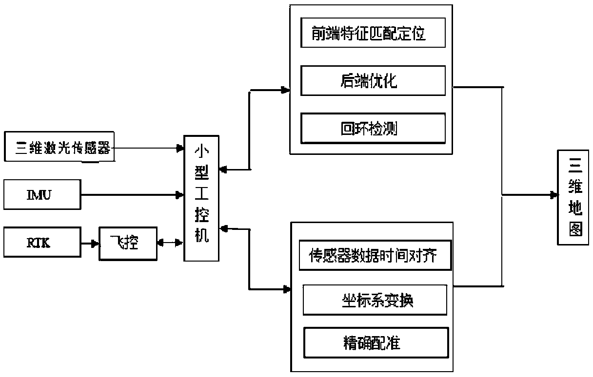
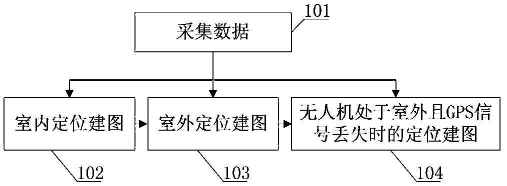
[0022] like figure 1 and 2 As shown, in some illustrative embodiments, a three-dimensional lidar-based multi-scene positioning and mapping method for drones is provided.

[0023] The 3D map describes the geometric structure of the environment through the point cloud data of the laser, realizes t...


PUM


Abstract

The invention provides a multi-scene drone locating and three-dimensional map mapping method based on a three-dimensional laser radar. In an indoor environment, when no GPS signal exists, a SLAM algorithm based on a three-dimensional laser sensor is built; in an outdoor environment, position information provided by RTK is mainly relied on to build the three-dimensional map, and after RTK loses theGPS signal, SLAM assists in locating. An indoor and outdoor three-dimensional map is quickly built, a convenient and efficient method is provided for obtaining the three-dimensional environment map,and the efficiency of building the three-dimensional environment map in the indoor environment and the outdoor environment is improved to a great extent; on the theoretical basis of mapping optimization of the SLAM algorithm, a drone platform SLAM algorithm is built based on the three-dimensional laser sensor, the three-dimensional environment map is built in the environment without the GPS signal, the problems of indoor locating and indoor and outdoor locating merging of a drone are solved, requirements of multi-scene drone locating are met, on the basis of obtaining high-precision attitude information, laser data is merged, and the three-dimensional map is built.

Description

technical field [0001] The invention relates to a multi-scene positioning and mapping method for UAVs based on three-dimensional laser radar, which is used for the construction of multi-scene three-dimensional point cloud maps for UAVs, and is suitable for indoor positioning and three-dimensional map construction, outdoor positioning and model construction of UAVs , Used in the field of UAV rescue and UAV surveying and mapping technology. Background technique [0002] With the rise of drones, the construction of 3D maps based on drone platforms has gradually come into people's field of vision. The 3D point cloud model of the environment can well express the position information of objects in the environment, and the acquisition of traditional 3D maps of complex and large scenes Professional equipment is required, which is time-consuming and expensive. Due to its easy-to-control and flexible features, UAVs have great potential in the establishment of 3D maps. In the construc...

Claims


Application Information

Patent Timeline
Patent Type & Authority Applications(China)
IPC IPC(8): G01S17/89
CPCG01S17/89
Inventor 徐朝文王伟杜浩肖冉
Owner 江苏中科智能科学技术应用研究院
Why Eureka
Try Eureka