Display method of enlarged navigation chart

A display method and a technology for enlarging images, applied in the field of navigation, can solve problems such as difficult road maintenance, error-prone, and inability to reflect destination names, etc., and achieve the effect of beautiful and reasonable image layout

Inactive Publication Date: 2018-09-04
WUHAN KOTEI INFORMATICS
View PDF5 Cites 3 Cited by
  • Summary
  • Abstract
  • Description
  • Claims
  • Application Information

AI Technical Summary

Problems solved by technology

[0003] In the past, the enlarged image display method mainly used static grid images for display. Because it is static, when the enlarged image is guided, only the pre-stored intersection guidance information can be displayed, and the destination name retrieved by the user in real time cannot be reflected ( For example, landmarks, street names, street numbers, etc.)
Moreover, the contents of the static grid images are mostly laid out manually by using image software, which requires a large amount of manual production, is prone to errors, and is difficult to maintain when the road changes.

Method used


Image

  • Display method of enlarged navigation chart
  • Display method of enlarged navigation chart
  • Display method of enlarged navigation chart

Examples


Embodiment Construction

[0027] The principles and features of the present invention are described below in conjunction with examples, which are only used to explain the present invention and are not intended to limit the scope of the present invention.

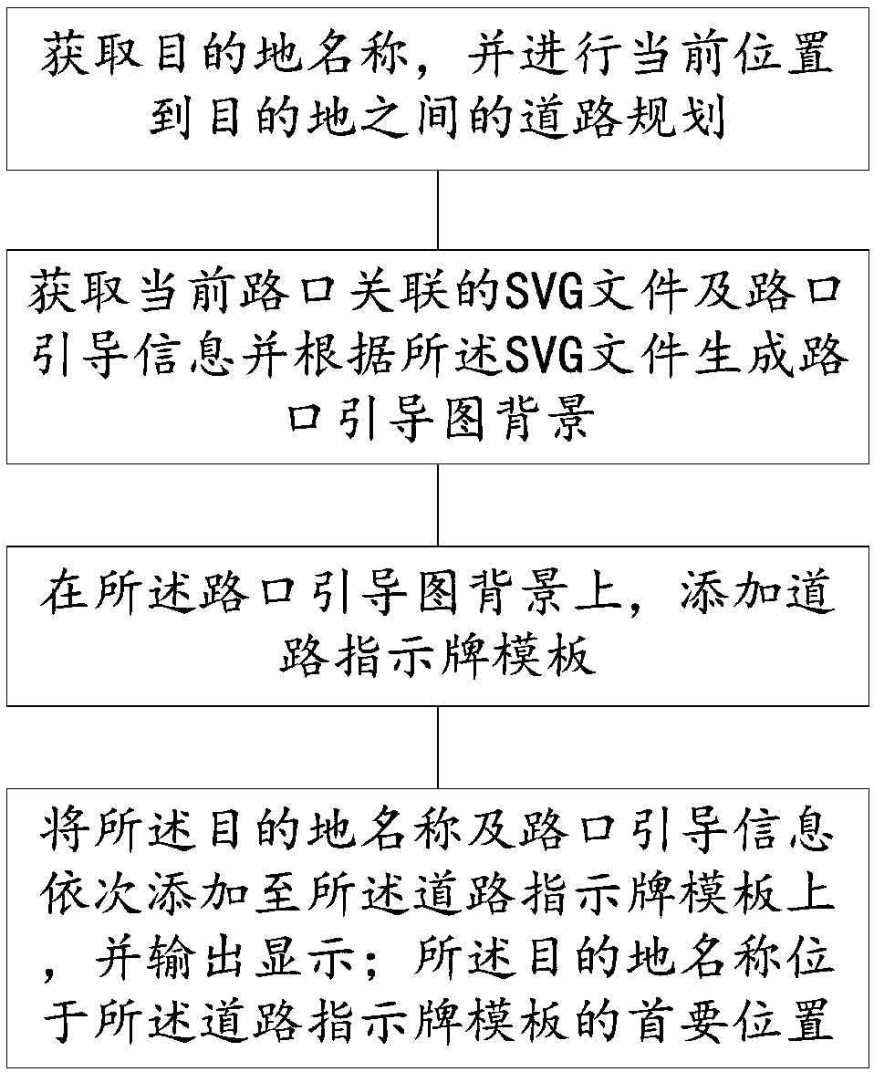
[0028] Such as figure 1 As shown, the present invention provides a method for displaying a navigation magnified map, comprising the following steps:

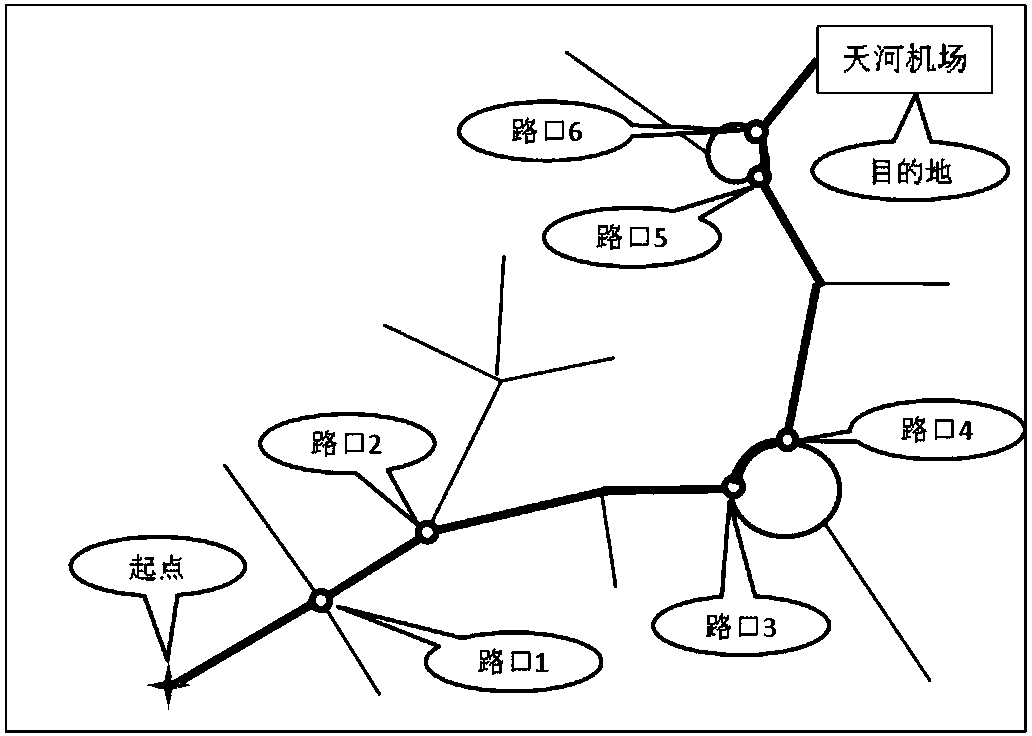
[0029] Step 1. Obtain the name of the destination, and plan the road between the current location and the destination;

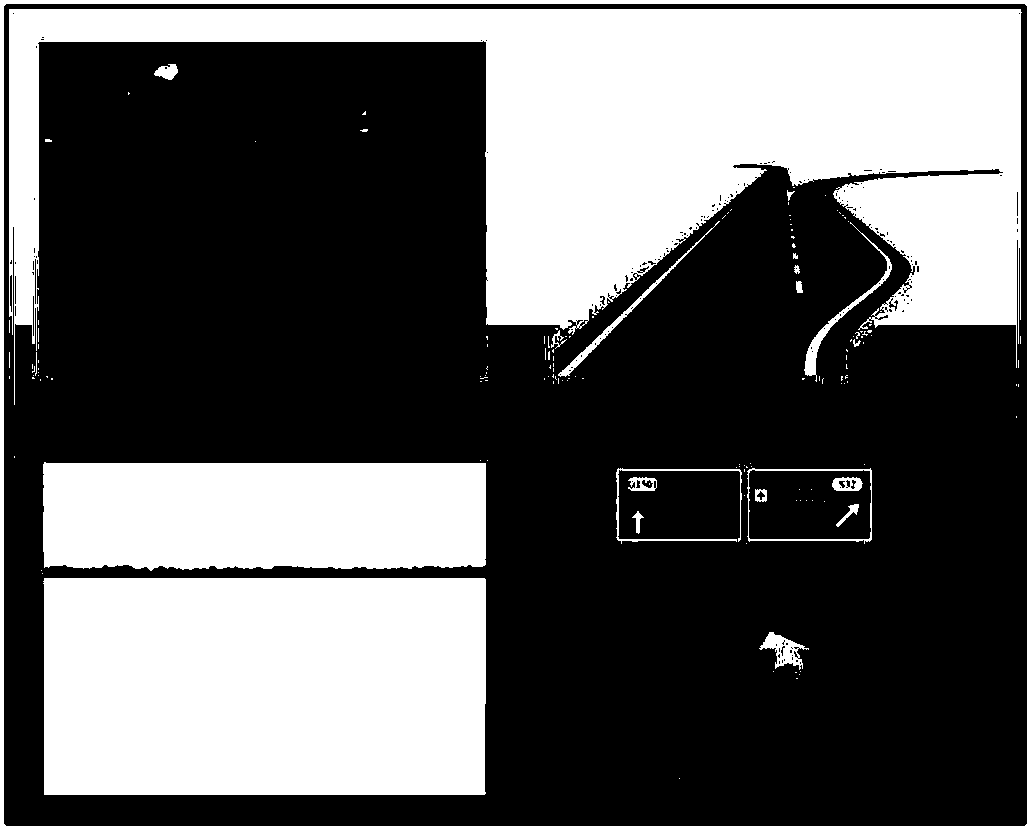
[0030] Step 2, obtain the SVG file associated with the current intersection and the intersection guide information and generate the intersection guide map background according to the SVG file;

[0031] Step 3, on the background of the intersection guide map, add a road sign template;

[0032] Step 4. Add the destination name and intersection guidance information to the road sign template in sequence, and output and display; the destination name is located at the primary position of...


PUM


Abstract

The invention relates to a display method of an enlarged navigation chart, which comprises the following steps of: acquiring the name of a destination, planning a road from the current position to thedestination, acquiring an SVG (scalable vector graphics) file and intersection guide information associated with the current intersection, generating an intersection guide chart background accordingto the SVG file, adding a road sign template on the intersection guide chart background, sequentially adding the name of the destination and the intersection guide information onto the road sign template, and performing output for displaying, wherein the name of the destination is located in a primary position on the road sign template. When the enlarged guide chart is displayed at each guide intersection, the name of the destination where a user goes is preferentially placed on a road sign on the chart and highlighted, so that a distinct guide mode is provided for the user; and the method more effectively helps the user to arrive at the destination.

Description

technical field [0001] The invention relates to the technical field of navigation, in particular to a method for displaying a navigation enlarged map. Background technique [0002] In order to facilitate the driver to drive the correct route before the motor vehicle passes through the intersection or high-speed entrance and exit, a graphical prompt method provided by the vehicle navigation terminal. The enlarged map mainly displays the road shape of the current intersection and the direction information in all directions of the intersection, such as landmarks, road names, etc., on a single map, with the purpose of intuitively guiding the driver. [0003] In the past, the enlarged image display method mainly used static grid images for display. Because it is static, when the enlarged image is guided, only the pre-stored intersection guidance information can be displayed, and the destination name retrieved by the user in real time cannot be reflected ( For example, landmarks,...

Claims


Application Information

Patent Timeline
Patent Type & Authority Applications(China)
IPC IPC(8): G01C21/36
CPCG01C21/3632
Inventor 朱敦尧杨飞
Owner WUHAN KOTEI INFORMATICS
Why Eureka
Try Eureka