Surveying and mapping planning system for rural housing construction system
A technology of planning and housing, which is applied in the field of surveying and mapping planning compilation system of the rural housing construction system, can solve problems such as the imperfect surveying and mapping planning compilation system, achieve the effect of shortening the work cycle, ensuring the quality of storage, and improving work efficiency
- Summary
- Abstract
- Description
- Claims
- Application Information
AI Technical Summary
Problems solved by technology
Method used
Image
Examples
Embodiment 1
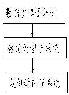
[0028] A surveying and mapping planning system suitable for rural housing construction system, including the following parts:
[0029] The data collection subsystem is used to obtain information such as the location, attributes, images, and sounds of target features;
[0030] The data processing subsystem is used to store the collected target feature information in the planning land use management database in the data processing subsystem;
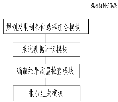
[0031] The planning compilation subsystem is used to superimpose and comprehensively analyze the collected target object information and the original spatial data information in the planning land management database, and issue a compilation report.
[0032] Such as figure 1 The surveying and mapping planning preparation system shown in the present invention integrates data collection, data processing and planning preparation, and can provide a relatively scientific and perfect planning surveying and mapping planning preparation system for...
Embodiment 2
[0034] A surveying and mapping planning system suitable for rural housing construction system, including the following parts:
[0035] The data collection subsystem is used to obtain information such as the location, attributes, images, and sounds of target features;
[0036] The data processing subsystem is used to store the collected target feature information in the planning land use management database in the data processing subsystem;
[0037] The planning compilation subsystem is used to superimpose and comprehensively analyze the collected target object information and the original spatial data information in the planning land management database, and issue a compilation report.
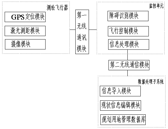
[0038] Further, the data collection subsystem includes a surveying and mapping aircraft and a monitoring unit, the monitoring unit is used to monitor the working status of the surveying and mapping aircraft and perform remote control, the monitoring unit includes an obstacle identification mod...
PUM
 Abstract
Description
Claims
Application Information
 - R&D
- Intellectual Property
- Life Sciences
- Materials
- Tech Scout
- Unparalleled Data Quality
- Higher Quality Content
- 60% Fewer Hallucinations
Browse by: Latest US Patents, China's latest patents, Technical Efficacy Thesaurus, Application Domain, Technology Topic, Popular Technical Reports.
© 2025 PatSnap. All rights reserved.Legal|Privacy policy|Modern Slavery Act Transparency Statement|Sitemap|About US| Contact US: help@patsnap.com


