Robot three-dimensional mapping method and system based on planar grid model

A plane grid and robot technology, applied in the field of environmental mapping, can solve the problems of processor volume limitation, poor portability and mobility, and large memory consumption, and achieve the effect of increasing diversity and simplicity.

Active Publication Date: 2018-11-27
肇庆市冠卓传媒科技有限公司
View PDF2 Cites 2 Cited by
  • Summary
  • Abstract
  • Description
  • Claims
  • Application Information

AI Technical Summary

Problems solved by technology

[0003] At present, the known automatic mapping methods for robots include two-dimensional and three-dimensional mapping, but the amount of environmental information provided by two-dimensional mapping is small, and it is difficult to construct complex environmental models, so that there are certain safety hazards when the robot works in a complex environment
The three-dimensional mapping method is a little cloud model and a grid model. The disadvantage of the point cloud model is that the computer memory consumption is huge, and the performance requirements of the processor are too high, so that the volume of the processor is also limited, and the small processing system cannot be used.
The grid model is currently the most widely used mapping method, but most of the existing methods use voxel models of the same size, and the memory consumption is still relatively large. A small number of methods use variable-size grids, but the modeling efficiency not tall
At the same time, the existing mapping system generally uses a general-purpose computer system, which is large in size, limited in embedded applications, and poor in portability and mobility.

Method used


Image

  • Robot three-dimensional mapping method and system based on planar grid model
  • Robot three-dimensional mapping method and system based on planar grid model

Examples


Embodiment 1

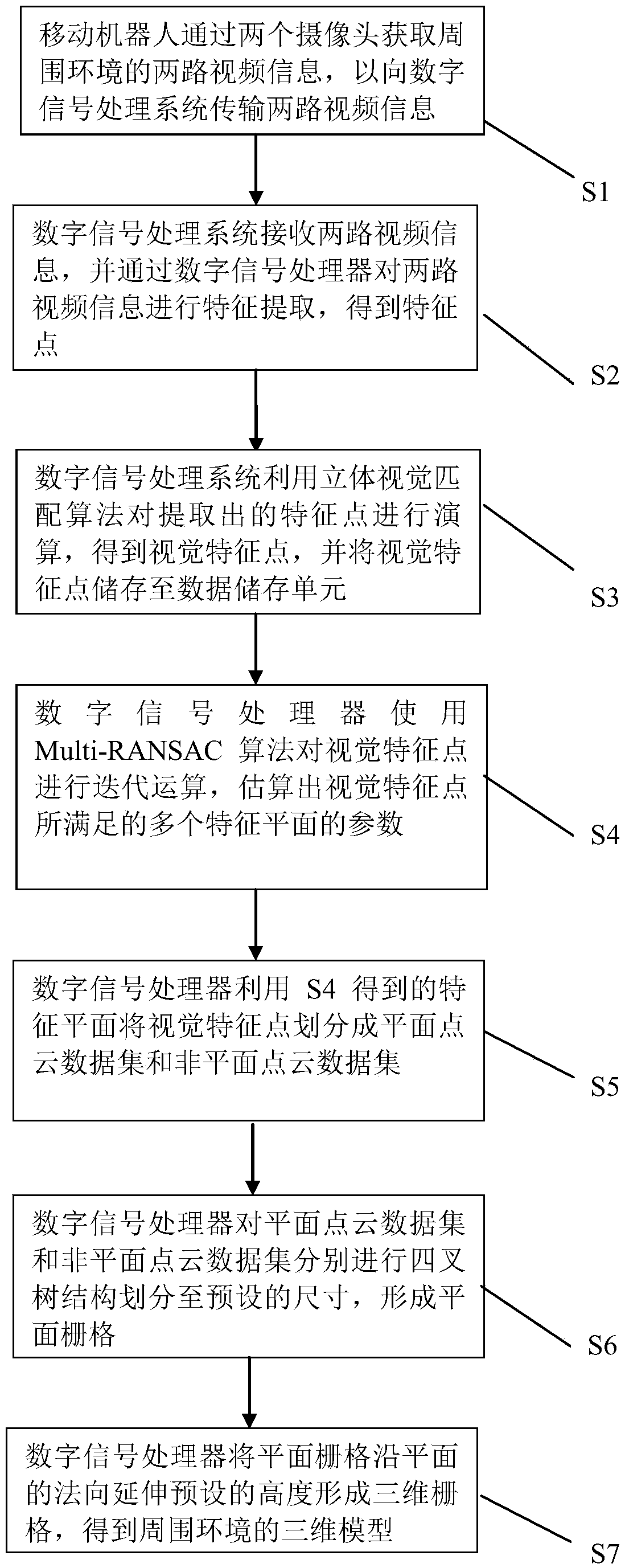
[0050] Such as figure 1 As shown, the present embodiment 1 discloses a method for three-dimensional mapping of a robot based on a plane grid model, comprising the following steps:

[0051] S1. The mobile robot obtains two channels of video information of the surrounding environment through two cameras, so as to transmit two channels of video information to the digital signal processing system;

[0052] S2. The digital signal processing system receives two channels of video information, and performs feature extraction on the two channels of video information through a digital signal processor to obtain feature points;

[0053] S3. The digital signal processing system uses a stereo vision matching algorithm to perform calculations on the extracted feature points to obtain visual feature points, and store the visual feature points in the data storage unit;

[0054] Specifically, the stereo vision matching algorithm in step S3 is a dynamic programming algorithm.

[0055] S4. The...

Embodiment 2

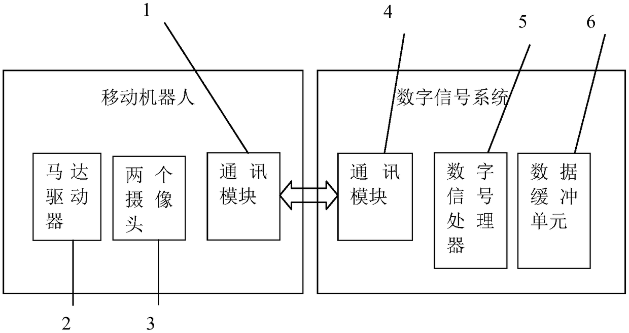
[0075] Such as figure 2 As shown, this embodiment discloses a robot three-dimensional mapping system based on a plane grid model, which includes a mobile robot and a digital signal processing system; the mobile robot includes:

[0076] Communication module 1, used to establish a connection with the digital signal processing system and transmit data and instructions;

[0077] The motor driver 2 is used to drive the mobile robot to move;

[0078] Two cameras 3 capture the surrounding environment to obtain two channels of video information;

[0079] Digital signal processing systems are embedded systems, including:

[0080] The communication module 4 is used to establish a connection with the mobile robot and transmit data and instructions;

[0081] The digital signal processor 5 is used to extract features from the two channels of video information, and perform stereo matching on the extracted feature points, thereby obtaining visual feature points, and processing the visual...


PUM


Abstract

The invention discloses a robot three-dimensional mapping method based on a planar grid model. The robot three-dimensional mapping method includes the following steps: allowing a mobile robot to use two cameras to shoot a surrounding environment to obtain two pieces of video information; performing feature extraction on the two pieces of video information in a digital signal processing system; performing stereo-matching on the extracted feature points to obtain visual feature points, and using the Multi-RANSAC algorithm to estimate a plurality of feature planes that the visual feature points satisfy; dividing the visual feature points into a planar point cloud data set and a non-planar point cloud data set; performing the quadtree structure division to a preset size, and forming a planar grid; and allowing the planar grid to extend a preset size in the normal direction of the plane to form a three-dimensional, thereby obtaining a three-dimensional model of the surrounding environment.The invention also discloses a robot three-dimensional mapping system based on the planar grid model. The technical scheme of the invention can allow the mobile robot to perform three-dimensional mapping on the working environment efficiently and accurately.

Description

technical field [0001] The invention belongs to the field of environment mapping, and in particular relates to a method and system for three-dimensional mapping of a robot based on a plane grid model. Background technique [0002] Environmental mapping plays an important role in the application of mobile robots, which can bring functions such as environmental detection, real-time positioning, and path planning to the application of mobile robots. With the development of robot technology, it has broad development prospects in robot applications. [0003] At present, the known automatic mapping methods for robots include two-dimensional and three-dimensional mapping, but the amount of environmental information provided by two-dimensional mapping is small, and it is difficult to construct complex environmental models, which makes robots have certain safety hazards when working in complex environments. The three-dimensional mapping method is a little cloud model and a grid mode...

Claims


Application Information

Patent Timeline
IPC IPC(8): G06T17/00G06T7/33
CPCG06T7/33G06T17/005G06T2207/10021
Inventor 郭炳华岑志松戴宏跃
Owner 肇庆市冠卓传媒科技有限公司
Why Eureka
Try Eureka