Weighting and identifying method for train track in turnout area based on satellite positioning

A satellite positioning and identification method technology, applied in satellite radio beacon positioning systems, measuring devices, instruments, etc., can solve problems that affect the correct identification of train lanes

Active Publication Date: 2018-12-25
BEIJING JIAOTONG UNIV
View PDF5 Cites 11 Cited by
  • Summary
  • Abstract
  • Description
  • Claims
  • Application Information

AI Technical Summary

Problems solved by technology

Affected by the propagation of satellite space signals and the receiver itself, there is a deviation between the satellite-based train positioning results and the real position of the train, which will affect the correct identification of the occupancy state of the train lane

Method used


Image

  • Weighting and identifying method for train track in turnout area based on satellite positioning
  • Weighting and identifying method for train track in turnout area based on satellite positioning
  • Weighting and identifying method for train track in turnout area based on satellite positioning

Examples


Embodiment Construction

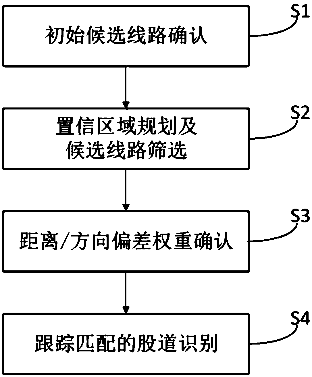
[0048] The satellite positioning-based train track weighted identification method in the turnout section of the present invention is realized by calculating and comparing satellite positioning information and DTM information. The method proposed by the present invention will be described in detail with reference to the drawings and examples.

[0049] The present invention determines that the train is at a known position of a known line before entering the turnout section, and no longer analyzes the operation line confirmation before the train enters the turnout section.

[0050] Such as figure 1 As shown, a method for weighted identification of train tracks in turnout sections based on satellite positioning includes the following steps:

[0051] S1: Confirm the running route of the train before entering the turnout section, and obtain the complete set of candidate routes OL by searching the map database according to the railway line topology relationship pre-stored in the map databas...


PUM


Abstract

The invention discloses a weighting and identifying method for train tracks in turnout areas based on satellite positioning. The method comprises the following steps of: S1, confirming a running lineof a train before entering a turnout area, and obtaining a candidate line full set OL (i = 1, 2, ...N) by retrieving a map database according to a railway line topological relation prestored in themap database, wherein i represents the line; S2, obtaining a train positioning result and visible satellite number information based on GNSS; constructing a confidence region based on the GNSS positioning information; calculating subsets of data points in the confidence region in the OL to obtain a candidate line set FL; S3, calculating a matching distance deviation and a direction deviation weight of each candidate line; establishing a candidate line weight function; calculating the weight of all the lines in the FL; selecting the line with the largest weight as a final matching line, and completing initial identification of the train in the turnout area; and S4, establishing accurate identification rules for the train tracks in the turnout areas, in combination with a topological structure of the railway line and a train running state.

Description

Technical field [0001] The invention relates to the field of train lane occupancy identification, and relates to a method for weighted identification of train lanes based on satellite positioning in turnout sections. Background technique [0002] The train position determination in the current train control system is mainly achieved through speed sensors combined with transponders. The train positioning technology based on the Global Navigation Satellite System (GNSS) can reduce the laying of trackside equipment and reduce construction and operating costs. Significant advantage. [0003] The railway system uses the one-dimensional mileage value as the expression form of the train position, which is inconsistent with the GNSS three-dimensional position coordinate expression form. The digital track map (DTM) can be used to realize the conversion from the GNSS positioning result to the one-dimensional mileage value. [0004] When the train runs in the turnout section, it is first neces...

Claims


Application Information

Patent Timeline
Patent Type & Authority Applications(China)
IPC IPC(8): G01S19/50
CPCG01S19/50
Inventor 陆德彪蔡伯根吴波前王剑上官伟刘江姜维
Owner BEIJING JIAOTONG UNIV
Why Eureka
Try Eureka