Industrial thermal anomaly region identification method based on multi-source satellite remote sensing data

A technology for satellite remote sensing data and thermal anomalies, applied in the field of data processing, can solve problems such as insufficient detail in the microscopic environment, and achieve targeted effects

Pending Publication Date: 2018-12-28
国际商业机器(中国)投资有限公司
View PDF0 Cites 22 Cited by
  • Summary
  • Abstract
  • Description
  • Claims
  • Application Information

AI Technical Summary

Problems solved by technology

However, 3km×3km is still not detailed enough for the micro-environment, and it is necessary to further l

Method used


Image

  • Industrial thermal anomaly region identification method based on multi-source satellite remote sensing data
  • Industrial thermal anomaly region identification method based on multi-source satellite remote sensing data
  • Industrial thermal anomaly region identification method based on multi-source satellite remote sensing data

Examples


Embodiment Construction

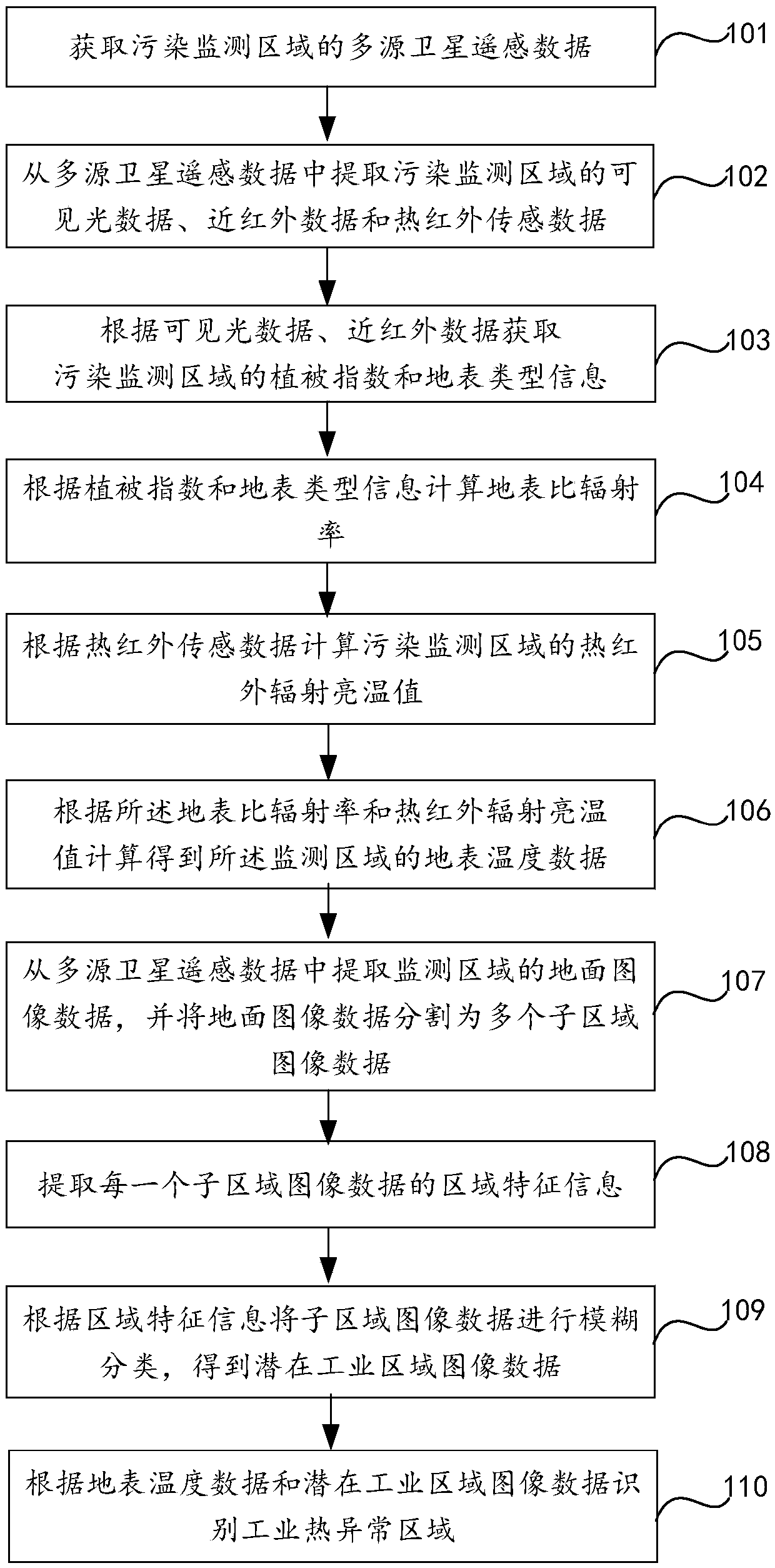
[0038] In order to make the object, technical solution and advantages of the present invention clearer, the present invention will be further described in detail below in conjunction with the accompanying drawings. Obviously, the described embodiments are only some embodiments of the present invention, rather than all embodiments . Based on the embodiments of the present invention, all other embodiments obtained by persons of ordinary skill in the art without making creative efforts belong to the protection scope of the present invention.

[0039] figure 1 It is a flowchart of a method for identifying industrial thermal anomalies based on multi-source satellite remote sensing data according to Embodiment 1 of the present invention. Such as figure 1 As shown, it specifically includes the following steps:

[0040] Step 101, obtaining multi-source satellite remote sensing data in the pollution monitoring area;

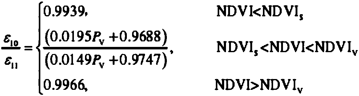
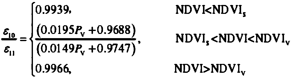
[0041] Extract polar-orbiting meteorological satellite remote se...


PUM


Abstract

The invention relates to a method for identifying industrial thermal anomaly region based on multi-source satellite remote sensing data, which comprises the following steps: acquiring multi-source satellite remote sensing data of pollution monitoring region; obtaining visible light data, near infrared data and thermal infrared sensing data from multi-source satellite remote sensing data; the vegetation index, surface type information and specific surface emissivity of the pollution monitoring area being calculated; calculating the brightness temperature of thermal infrared radiation in the pollution monitoring area; calculating the surface temperature data of the monitoring area; extracting ground image data of monitoring area from multi-source satellite remote sensing data, and dividing the ground image data into a plurality of sub-area image data; extracting region feature information of each sub-region image data; fuzzy classification of sub-region image data to obtain potential industrial region image data; industrial thermal anomaly regions being identified based on surface temperature data and potential industrial region image data.

Description

technical field [0001] The invention relates to the technical field of data processing, in particular to a method for identifying industrial thermal anomalies based on multi-source satellite remote sensing data. Background technique [0002] Remote sensing image recognition refers to the use of computers to analyze the spectral information and spatial information of various ground objects in remote sensing images, select features, and use certain means to divide the feature space into subspaces that do not overlap with each other, and then divide each feature in the image. The pixels are assigned to the corresponding feature categories of each subspace. With the development of remote sensing technology, the application of a large number of different satellite sensors such as optical, thermal infrared and microwave to earth observation, the acquisition of multiple remote sensing image data (multi-temporal, multi-spectral, multi-sensor, multi-platform and multi-resolution) in ...

Claims


Application Information

Patent Timeline
IPC IPC(8): G06K9/00
CPCG06V20/194G06V20/188G06V20/13
Inventor 廖炳瑜丁相元汤宇佳范迎春
Owner 国际商业机器(中国)投资有限公司
Why Eureka
Try Eureka