Detection method for passable area based on three-dimensional laser radar

A technology of three-dimensional laser and traffic area, which is applied in the direction of measuring device, electromagnetic wave re-radiation, radio wave measurement system, etc., can solve the problems of no map prior information available, loss of GPS signal, large change of road width, etc., to achieve optimization Passable area, the effect of solving the divergence of passable area

Inactive Publication Date: 2019-01-15
合肥中科智驰科技有限公司
View PDF5 Cites 9 Cited by
  • Summary
  • Abstract
  • Description
  • Claims
  • Application Information

AI Technical Summary

Problems solved by technology

However, in the face of complex outdoor environments, especially unstructured road environments, the ability to understand the environment of unmanned vehicles faces many challenges.
[0003] In an unstructured environment, there will be problems such as no road markings, undulating ground, irregular road boundaries, large changes in road width, loss of GPS signals, and no map prior information available, so relying solely on road boundary detection methods no longer applicable

Method used


Image

  • Detection method for passable area based on three-dimensional laser radar
  • Detection method for passable area based on three-dimensional laser radar
  • Detection method for passable area based on three-dimensional laser radar

Examples


Embodiment Construction

[0034] To make the objectives, technical solutions, and advantages of the embodiments of the present invention clearer, the technical solutions in the embodiments of the present invention will be described clearly and completely in conjunction with the accompanying drawings in the embodiments of the present invention. Obviously, the described embodiments are part of the embodiments of the present invention, rather than all of the embodiments. Based on the embodiments of the present invention, all other embodiments obtained by those of ordinary skill in the art without creative work shall fall within the protection scope of the present invention.

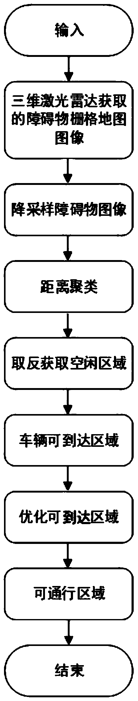
[0035] Passable area detection method based on three-dimensional lidar, such as figure 1 As shown, including the following steps:

[0036] S1, the three-dimensional lidar obtains the obstacle grid map image;

[0037] S2. Use the distance function to cluster the obstacles and calculate the Euclidean distance between any two obstacle points...


PUM


Abstract

The invention relates to unmanned vehicles, and specifically relates to a detection method for a passable area based on a three-dimensional laser radar. The method comprises the following steps: acquiring an obstacle grid map image by a three-dimensional laser radar; clustering obstacles by using a distance function; calculating an Euclidean distance between any two obstacle points in the obstaclegrid map, and connecting the two obstacle points in a straight line if the Euclidean distance is smaller than a clustering threshold T, the points on the straight line are considered to be the obstacles; performing a reverse operation right after distance clustering to obtain an idle region; removing corners not suitable for vehicle passing in the idle region; acquiring a reachable area on an idle area starting from a vehicle position; performing down-sampling on the reachable area to return to the obstacle grid map in an original size; and optimizing the reachable area. According to the technical scheme provided by the invention, the defect that a safe driving region is difficult to divide by using boundary and point cloud smoothness features in the prior art can be effectively overcome.

Description

Technical field [0001] The invention relates to unmanned driving, in particular to a passable area detection method based on a three-dimensional laser radar. Background technique [0002] As a mobile robot that can drive autonomously and safely avoid obstacles in an outdoor environment, unmanned vehicles can reduce the incidence of traffic accidents, reduce casualties and economic losses, and have great research value and broadness in civil and national defense. Application prospects. One of the most important functions of unmanned vehicles is that they can navigate autonomously, which requires their ability to perceive and understand the environment to ensure that they can drive safely in the correct area. However, in the face of complex outdoor environments, especially unstructured road environments, the ability of unmanned vehicles to understand the environment faces many challenges. [0003] In an unstructured environment, there will be problems such as no road markings, undu...

Claims


Application Information

Patent Timeline
IPC IPC(8): G01S17/93G01S17/89
CPCG01S17/89G01S17/931
Inventor 江如海袁胜
Owner 合肥中科智驰科技有限公司
Why Eureka
Try Eureka