A positioning method and positioning system

A positioning method and current location technology, applied in location information-based services, specific environment-based services, connection management, etc., can solve the problem of low positioning accuracy, achieve convenient practical application, wide applicability, and reduce interference errors Effect

Active Publication Date: 2020-09-18
NAT UNIV OF DEFENSE TECH
View PDF9 Cites 0 Cited by
  • Summary
  • Abstract
  • Description
  • Claims
  • Application Information

AI Technical Summary

Problems solved by technology

[0004] The invention provides a positioning method and a positioning system, which are used to overcome the defects of low positioning accuracy in the prior art, and perform distance calculation and positioning through multiple ranging terminals, and then fuse the data of multiple ranging terminals to reduce the external The impact of environmental factors on the channel improves the accuracy of positioning

Method used


Image

  • A positioning method and positioning system
  • A positioning method and positioning system
  • A positioning method and positioning system

Examples


Embodiment 1

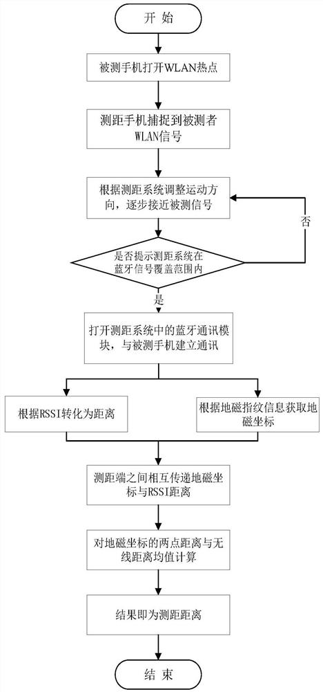
[0036] Please refer to figure 1 , the present invention provides a positioning method, comprising:

[0037] Step 1, arrange at least three measurement nodes;

[0038] Step 2, open the WLAN hotspot of the measured point, and the measurement nodes capture the WLAN signal of the measured point respectively;

[0039] Step 3, the measuring nodes move towards the direction close to the measured point according to the strength of the WLAN signal captured respectively;

[0040] Step 4, the measurement node establishes a communication connection with the measured point through Bluetooth when it enters the coverage area of ​​the Bluetooth signal;

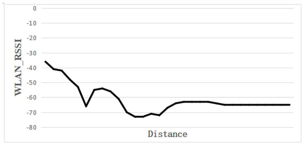
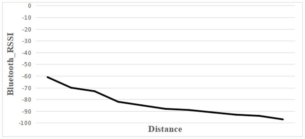
[0041] Step 5, each of the measurement nodes obtains the geomagnetic coordinates of the measured point through Bluetooth; each of the measurement nodes obtains the RSSI value of the measured point through Bluetooth and WLAN and fuses them;

[0042] Step 6: Obtain the geomagnetic distance between the ranging terminal and the measured point ...

Embodiment 2

[0091] Please refer to Figure 5 , on the basis of Embodiment 1, the present invention provides a positioning system, including a node arrangement module 1, a capture module 2, a mobile module 3, a communication module 4, a geomagnetic and RSSI module 5, a ranging module 6, and a location module 7, Wherein: node arrangement module 1 is used for arranging at least three measuring nodes; Capturing module 2 is used for opening measured point WLAN hotspot, and described measuring node captures measured point WLAN signal respectively; Mobile module 3 is used for described measuring node according to respective The strength of the captured WLAN signal moves towards the direction of the measured point; the communication module 4 is used for establishing a communication connection between the measurement node and the measured point through Bluetooth when entering the Bluetooth signal coverage The geomagnetic and RSSI module 5 is used for each of the measuring nodes to obtain the geoma...


PUM


Abstract

The invention discloses a positioning method and a positioning system. The method comprises arranging at least three measurement nodes; opening a measured point WLAN hotspot in order that the measurement nodes separately capture a measured point WLAN signal; enabling the measurement nodes to move toward the measured point according to the WLAN signal intensities captured by the measurement node respectively; enabling the measurement nodes to establish Bluetooth communication with the measured point when entering the coverage of a Bluetooth signal; enabling each measurement node to acquire thegeomagnetic coordinates of the measured point through Bluetooth; enabling each measurement node to obtain and fuse the RSSI value of the measured point through the Bluetooth and WLAN; obtaining the geomagnetic distance between a measurement end and the measured point according to the geomagnetic coordinates of the measurement nodes and the measured point, obtaining the wireless distance between the measurement nodes and the measured point according to the RSSI value, and performing data fusion on the geomagnetic distance and the wireless distance to obtain a ranging result; and obtaining the position of the measured point according to the ranging result and the positions of the respective measurement nodes. The method solves a large positioning error and improves the accuracy of positioning.

Description

technical field [0001] The invention relates to the technical field of geomagnetic-assisted RSSI (Received Signal Strength Indication) indoor positioning, in particular to a positioning method and a positioning system. Background technique [0002] In the positioning algorithm based on distance measurement, angle of arrival AOA (Angle-of-Arrival), time difference of arrival DTOA (Difference Time Of Arrival) and RSSI are often used (the distance between the signal point and the receiving point is measured by the strength of the received signal, and then according to Corresponding data for positioning calculation of a positioning technology) ranging algorithm. Among them, RSSI ranging does not require additional hardware equipment. According to the signal strength at both ends of the transceiver, combined with the channel signal fading model, the signal strength is converted into a distance. Indoor navigation can also be used in emergency rescue environments, which is of grea...

Claims


Application Information

Patent Timeline
Patent Type & Authority Patents(China)
IPC IPC(8): H04W4/029H04W4/33H04W4/80H04W64/00H04W76/14G01C21/08H04W84/12
CPCG01C21/08H04W4/029H04W4/33H04W4/80H04W64/006H04W76/14H04W84/12
Inventor 张斌鲍庆龙王森顾善植
Owner NAT UNIV OF DEFENSE TECH
Why Eureka
Try Eureka