Real-time road matching method based on vehicle travel records and system

A driving record and matching method technology, applied in the field of geographic information system, can solve the problems of difficulty in ensuring the road matching accuracy of driving records, reduce matching efficiency, time lag, etc., and achieve a reasonable road matching process, improve matching efficiency, and reliable results. Effect

Active Publication Date: 2019-02-05
XIAMEN YAXON NETWORKS CO LTD
View PDF11 Cites 3 Cited by
  • Summary
  • Abstract
  • Description
  • Claims
  • Application Information

AI Technical Summary

Problems solved by technology

In a complex road network, it is difficult to guarantee the accuracy of driving record road matching by using a single method; although the comprehensive method improves the matching accuracy, it also greatly reduces the matching efficiency, resulting in a certain time lag.

Method used


Image

  • Real-time road matching method based on vehicle travel records and system
  • Real-time road matching method based on vehicle travel records and system
  • Real-time road matching method based on vehicle travel records and system

Examples


Embodiment 1

[0043] see figure 1 As shown, the present invention provides a kind of real-time road matching method based on driving record, comprises the steps:

[0044] 1 Commonly used driving areas or urban map road data processing, the specific content is:

[0045] 11 Obtain the road (such as latitude and longitude, one-way, two-way, etc.) data of the vector map;

[0046] 12 Cut the road according to the latitude and longitude of the road nodes, so that the intersection between roads can only be the head and tail nodes of the road, and give each road a unique ID number;

[0047] 13 Calculate the node spacing and road length of each road according to the latitude and longitude of the road. For example, the latitude and longitude of two adjacent nodes of the known road are (Ψ A ,Φ A ), (Ψ B ,Φ B ) then its distance is

[0048]

[0049] Where Γ=arccos(sin(Φ A )sin(Φ B )+cos(Φ A )cos(Φ B )cos(Ψ A -Ψ B )), R is the average radius of the earth (getting 6371.0088 kilometers) and...

Embodiment 2

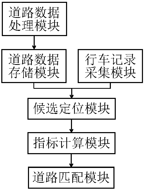
[0091] Such as figure 1 As shown, this embodiment proposes a system, including a collection module for collecting driving records and road data, a control module for executing control programs, and a storage module carrying programs, wherein the program executes the driving record based on driving records in the first embodiment. real-time road matching method.

[0092] Specifically, the acquisition module includes a driving record acquisition module and a road data acquisition module, the storage module includes a road data storage module and a program storage module, and the control module includes a road data processing module, a candidate positioning module, an index calculation module and a road matching module, wherein ,

[0093] The road data processing module is used to process the road data of the vector map, and respectively obtains road (road ID, node latitude and longitude, length, direction), point (road node and interpolation point latitude and longitude, road I...


PUM


Abstract

The invention discloses a real-time road matching method based on vehicle travel records. The method includes: S1, collecting the vehicle travel records, and acquiring road data; S2, determining candidate positioning points, wherein a positioning area of the collected vehicle travel records is calculated, and positioning is carried out according to the acquired road data to determine the candidatepositioning points of the vehicle travel records; S3, calculating evaluation indexes of the candidate positioning points and candidate matching roads, wherein evaluation indexes of the determined candidate positioning points are calculated, and then evaluation indexes of the candidate matching roads are calculated; and S4, carrying out road matching, wherein best candidate matching roads are acquired according to the evaluation indexes of the candidate matching roads, and a best candidate matching road of a last valid vehicle travel record is determined as a road matching result. A system includes a collection module collecting the vehicle travel records and the road data, a control module executing a control program and a storage module carrying the program. The program executes the real-time road matching method based on the vehicle travel records.

Description

technical field [0001] The invention relates to the technical field of geographic information systems, in particular to a real-time road matching method and system based on driving records. Background technique [0002] For map road matching, commonly used methods are: geometric method, topological method, probability method, other comprehensive methods, etc. Among them, the geometric method is mainly based on the distance from the driving record to the nearby road nodes or the projection distance of the road section to implement road matching, such as the invention patent CN201310183257. record for road matching, such as the invention patent CN201610483028.4; the probabilistic method mainly considers the position probability of the driving record on the map road to complete road matching, such as the invention patent CN201410515570.4; while other comprehensive methods use Kalman filter, fuzzy Logical models, evidence theory models, hidden Markov models, etc. are used to co...

Claims


Application Information

Patent Timeline
IPC IPC(8): G01C21/34
CPCG01C21/3415G01C21/3446
Inventor 阮志毅洪志新石春晖
Owner XIAMEN YAXON NETWORKS CO LTD
Why Eureka
Try Eureka