Extraction method and medium of ecological value index of land use in spatial expansion of urban agglomeration

A technology of value index and space expansion, applied in the field of data processing, can solve the problems that the research on the impact mechanism between the expansion and the ecological environment has not yet been raised, and achieve the effect of improving research efficiency

Inactive Publication Date: 2019-02-19
INST OF GEOGRAPHICAL SCI & NATURAL RESOURCE RES CAS
3 Cites 2 Cited by

AI-Extracted Technical Summary

Problems solved by technology

[0004] The present invention provides a land use ecological value index extraction method and medium for urban agglomeration spatial expansion, to at least solve the problem...

Method used

Through the above-mentioned steps, on the one hand, through the four dimensions of land use type change rate, land use type flow index, land use type relative change rate, and the ecological value contribution rate of land use type change, urban agglomeration areas can be presented during the research period (for example The evolution of the ecological value index related to the change of land use type in...

Abstract

The invention provides a method and a medium for extracting land ecological value index of spatial expansion of urban agglomeration. The method includes: acquiring the spatial data of land use/land cover in Coverage format from the database of urban agglomeration by using GIS technology, and preprocessing the spatial data; Loading a calculation model from a calculation model base, and calculatingan ecological value index of different land types of the urban agglomeration region in the study period by using the loaded calculation model and the spatial data; Chart exporting ecological value indices. The invention solves the problem that an effective solution is not provided for the study of the influence mechanism between the spatial expansion of the urban agglomeration and the ecological environment in the related technology, and not only provides a method capable of effectively studying the influence mechanism between the spatial expansion of the urban agglomeration and the ecologicalenvironment, but also improves the research efficiency.

Application Domain

Geographical information databasesResources

Technology Topic

Computational modelLand utilization +8

Image

  • Extraction method and medium of ecological value index of land use in spatial expansion of urban agglomeration
  • Extraction method and medium of ecological value index of land use in spatial expansion of urban agglomeration
  • Extraction method and medium of ecological value index of land use in spatial expansion of urban agglomeration

Examples

  • Experimental program(1)

Example Embodiment

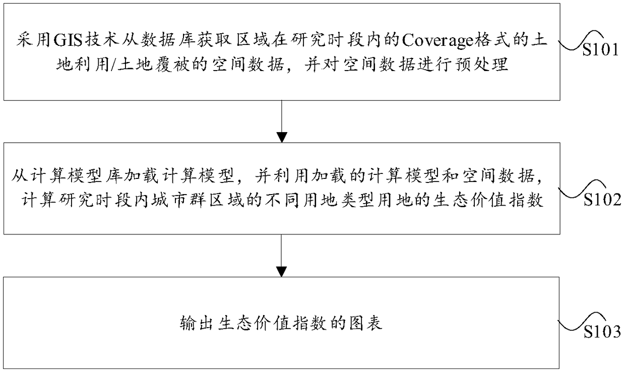
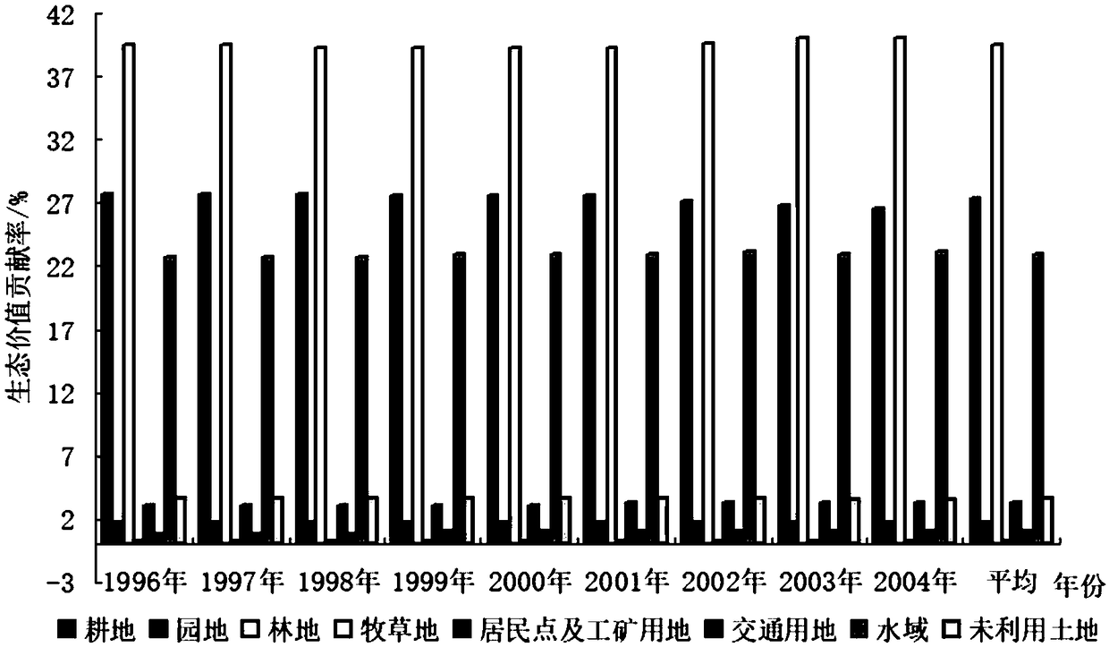
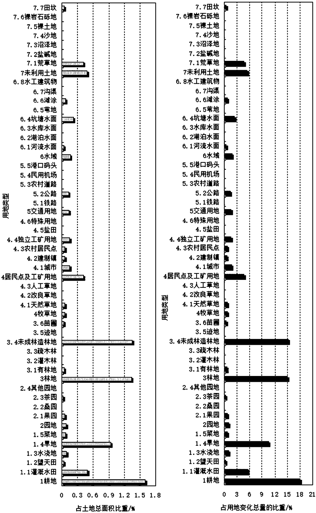
[0021] The characteristics and exemplary embodiments of various aspects of the present invention will be described in detail below. In order to make the purpose, technical solutions and advantages of the present invention more clear, the present invention will be further described in detail below in conjunction with the accompanying drawings and embodiments. It should be understood that the specific embodiments described here are only used to explain the present invention, not to limit the present invention. It will be apparent to one skilled in the art that the present invention may be practiced without some of these specific details. The following description of the embodiments is only to provide a better understanding of the present invention by showing examples of the present invention.
[0022] It should be noted that, in this document, the term "comprising", "comprising" or any other variation thereof is intended to cover a non-exclusive inclusion such that a process, method, article or apparatus comprising a set of elements includes not only those elements, It also includes other elements not expressly listed, or elements inherent in the process, method, article, or apparatus. Without further limitations, an element defined by the statement "comprising..." does not exclude the presence of additional same elements in the process, method, article or device comprising said element.
[0023] In this embodiment, a method for extracting the land use ecological value index of the spatial expansion of the urban agglomeration area is provided. figure 1 It is a flow chart of the method for extracting the land use ecological value index of the spatial expansion of the urban agglomeration area according to the embodiment of the present invention, such as figure 1 As shown, the process includes the following steps:
[0024] Step S101, using GIS technology to obtain the spatial data of land use/land cover in the coverage format of the urban agglomeration area within the research period from the database, and preprocessing the spatial data;
[0025] Step S102, load the calculation model from the calculation model library, and use the loaded calculation model and spatial data to calculate the ecological value index of different types of land use in the urban agglomeration area within the research period. The calculation model includes but is not limited to at least one of the following: land use Type change rate calculation model, land use type flow index calculation model, land use type relative change rate calculation model, and land use type change ecological value contribution rate calculation model;
[0026] Step S103, outputting a graph of the ecological value index.
[0027] Through the above steps, on the one hand, through the four dimensions of land use type change rate, land use type flow index, land use type relative change rate, and ecological value contribution rate of land use type change, it is possible to present the urban agglomeration area in the research period (for example, multiple years). The evolution of the ecological value index related to the change of land use type in ) can reflect the dynamic evolution of the interactive change of land use type in the urban agglomeration area; Acquisition, calculation, and chart output not only greatly improve research efficiency and reduce human errors, but also facilitate the update and expansion of research methods through iterative updates of calculation models in the calculation model library.
[0028] Optionally, before step S102, the method for extracting the land use ecological value index of urban agglomeration spatial expansion in this embodiment may further include the following steps: obtaining the current land use data of the urban agglomeration area during the research period from the database, and according to the spatial The data classification standard adjusts the type of land use status data;
[0029] Among them, the calculation model of the calculation model library also includes but is not limited to at least one of the following: the calculation model of the ecological value contribution rate of the urban agglomeration area of ​​the land use type, and the calculation model of the contribution rate of the ecological value change of the land use type.
[0030] The above-mentioned extraction method of land use ecological value index for spatial expansion of urban agglomeration area can be applied to the extraction of ecological value index of any urban agglomeration area, and the calculation model used in the above method is not limited to a specific calculation model. These calculation models are pre-set in the calculation model library, and the calculation models for calculating the corresponding indices are associated or determined through pre-configuration or user selection, and the calculation models in the calculation model library can be added, deleted or updated manually.
[0031] In this embodiment, the Wuhan urban agglomeration will be taken as an example, and a preferred calculation model will be used to describe and illustrate the method of the embodiment of the present invention.
[0032] In this example, two sets of data are used: the first set of data is the spatial data of land use/land cover in Coverage format in 1980, 1995 and 2000, which is used to analyze the ecological response of spatial expansion, and the data includes 25 secondary types ; According to the research objectives, the 25 secondary types can be divided into two categories: one category is urban land, including urban and rural areas, industrial and mining, and residential land; the other category is ecological land, including cultivated land, forest land, and grassland 5 subcategories, water area and unused land; the second set of data is the current land use data from 1996 to 2004, which is used to analyze the ecological environment constraint mechanism of spatial expansion, and the data includes 48 secondary types. The second set of data is more detailed and can reflect construction land (including traffic land, residential land, etc.), and is more suitable for mechanism analysis.
[0033] In this example, based on the research on the ecological function zones of urban agglomerations, the changes between various types of land use are further studied, including the change relationship and spatial relationship between various land use types, focusing on the analysis of urban land use and ecological land use. The first set of data is used as the data, and the land use type change data is output through the GIS spatial analysis module; secondly, the interaction mechanism between the spatial expansion of the urban agglomeration and the ecological elements is summarized, supported by the analysis results of the second set of data, On this basis, the spatial expansion direction of Wuhan urban agglomeration and the strategic orientation of ecological protection are put forward.
[0034] Part I, Ecological Land Value of Spatial Expansion of Urban Agglomeration
[0035] Using the land use status data from 1996 to 2004, using the two indices of urban agglomeration regional ecological value contribution rate and land use type ecological value change contribution rate to analyze the ecological impact of urban agglomeration spatial expansion in Wuhan and its ecological impact The spatial difference of the impact, summarizing the basic characteristics of the ecological land use pattern of the urban agglomeration.
[0036] 1. Urban agglomeration land use pattern and ecological value
[0037] 1. Data source and processing
[0038]Step 1.1: Obtain the current land use data of the urban agglomeration area during the research period from the database, and adjust the type of land use data according to the classification standard of spatial data.
[0039] Since the research on land use patterns of urban agglomerations does not involve changes in land use/land cover (i.e. land use change data), in this example, the data on the current status of land use from 1996 to 2004 with more detailed classifications (divided into 8 1 first-level type and 48 second-level types, see Table 1.1), to study the spatial expansion carrier of urban agglomeration—urban and rural residential areas, industrial and mining land, transportation land, and the impact of changes on ecology (see Table 1.2).
[0040] Table 1.1 Ecological value assignment table of different land use types in urban agglomeration
[0041]
[0042] Due to the differences in classification standards between this data and the spatial data of land use/land cover in Coverage format in 1980, 1995 and 2000, in order to unify the research caliber, it was modified as follows: Livestock and poultry breeding land and grain drying land Classified as land for rural residential areas; combine rural roads with transportation land; combine pit pond water surface and aquaculture water surface into pit pond water surface; replace farmland water use land with ditches; use field ridges as unused land; Agricultural land is considered a separate land use type. At the same time, with reference to the ecological value contribution rate assignment of the first set of data, the ecological values ​​of 48 secondary types are assigned respectively.
[0043] 2. Calculation of ecological value and contribution rate of urban agglomeration land types
[0044] Step 1.2, load the calculation model from the calculation model library, and use the loaded calculation model and spatial data to calculate the ecological value index of different land use types in the urban agglomeration area within the research period. The calculation model includes at least one of the following: cities with land use types The calculation model for the contribution rate of the ecological value of the group area and the calculation model for the contribution rate of the change of the ecological value of the land use type.
[0045] (1) Contribution rate of urban agglomeration regional ecological value by land use type. The index reflects the total ecological value of each land use type in the urban agglomeration, and at the same time reflects the contribution rate of each land use type to the total ecological value of the urban agglomeration.
[0046]
[0047] In the formula, Evr i is the regional ecological value contribution rate of urban agglomeration of land use type i in the study period; LU i Indicates the area of ​​land use type i within the study period, C i Indicates the ecological value contribution rate of land use type i, and n is the total number of land use types.
[0048] (2) Contribution rate of changes in ecological value of land use types. The index does not consider the annual change of ecological quality, but only considers the change of ecological value of the same land type within the research period (for example, in the same year) and its proportion in the total change of ecological value of the urban agglomeration, that is, the contribution rate. If Ling Ev imax and Ev imin are the maximum ecological value and minimum ecological value of a certain land use type in the study period, respectively. The formula for calculating the contribution rate of ecological value change of land use type is:
[0049]
[0050] 2. Output charts to analyze the basic characteristics of the urban agglomeration ecological land pattern
[0051] Step 1.3, output the graph of the contribution rate of urban agglomeration regional ecological value of land use type and the contribution rate of ecological value change of land use type.
[0052] 1. Regional ecological value contribution rate of forest land, cultivated land and water area and its annual change
[0053] Forest land, cultivated land, and waters in Wuhan urban agglomeration have the largest ecological contribution rate, and are the most important types that determine the ecological environment changes caused by urban agglomeration expansion (see Table 1.2, figure 2 ).
[0054] Table 1.2 Contribution rate of regional ecological value of different land use types in different years in Wuhan urban agglomeration/%
[0055]
[0056]
[0057]
[0058] 2. Contribution rate and annual change of urban agglomeration regional ecological value of residential areas, industrial and mining land and transportation land
[0059] refer to figure 2 As shown in Table 1.2, the urban agglomeration ecological value contribution rate of urban and rural residential areas, industrial and mining land, and transportation use in the Wuhan urban agglomeration is generally low, but rural residential area land and transportation land are still the types of land that contribute the largest ecological value contribution rate in the urban agglomeration area.
[0060] From the perspective of annual changes, compared with other land uses, the rate of change in the ecological value contribution rate of urban agglomerations of transportation land, residential areas, and industrial and mining land is relatively high, indicating that the main carrier of urban agglomeration spatial expansion has relatively drastic changes. However, because its ecological value itself is relatively small, the "positive" ecological contribution rate of its land use change is not high.
[0061] 3. Differences in the contribution rates of changes in land use types to the ecological value of urban agglomerations
[0062] The difference in the contribution rate of the change of each land use type in the Wuhan urban agglomeration to the regional ecological value of the urban agglomeration is manifested in two aspects: First, the overall difference is relatively large. For example, the highest contribution rate of change is the immature forest land, followed by irrigated paddy field, dry land and pond water surface. In addition, tidal flats, natural grasslands, and river water surfaces also contributed more than 2%. Relatively speaking, the contribution rate of residential areas and industrial and mining land is extremely low. Second, there are large internal differences. For example, Wang Tian Tian, ​​irrigated land, and vegetable land in the cultivated land, due to their small area, the ecological value of the urban agglomeration caused by the change will not change much; the contribution rate of the orchard is the highest among the garden land; In addition, the contribution rate is low; among residential areas and industrial and mining land, cities, rural residential areas, and independent industrial and mining land are the largest; among transportation land, the contribution rate of roads is much higher than that of railways and other lands, and significantly higher than that of railways. It can be seen that the ecological impact of highways on urban agglomerations is huge; in water areas, the contribution rate of pond water surface is the largest, followed by river water surface and tidal flats; in unused land, the contribution rate of waste grassland is relatively high (see Table 1.3).
[0063] Table 1.3 Ecological value impact of different land use types in Wuhan urban agglomeration
[0064]
[0065]
[0066] The second part, the replacement of ecological land value in urban agglomeration spatial expansion
[0067] 1. The dynamic evolution of the interactive conversion of urban agglomeration land types
[0068] 1. Data source and processing
[0069] Step 2.1, use GIS technology to obtain the spatial data of land use/land cover in the coverage format of the urban agglomeration area within the research period from the database, and preprocess the spatial data.
[0070] Since the content of this research involves land use change, the spatial data of land use/land cover in 1980, 1995 and 2000 Coverage formats are used. The preprocessing method includes: using GIS technology to separate the strata of different years in the research period from the database; superimposing the separated strata of different years, calculating the area of ​​the superposition range, and judging the difference between different land types. The relationship between encroachment and encroachment.
[0071] 2. Research methods
[0072] Step 2.2, load the calculation model from the calculation model library, and use the loaded calculation model and spatial data to calculate the ecological value index of different land use types in the urban agglomeration area within the research period. The calculation model includes at least one of the following: land use type change rate Calculation model, calculation model of land use type flow direction index, calculation model of relative change rate of land use type, calculation model of ecological value contribution rate of land use type change.
[0073] The evolution process of urban agglomeration land use type and its ecological value is reflected by the ecological value index such as land use type change rate, land use type flow index, land use type relative change rate, and the ecological value contribution rate of land use type change.
[0074] (1) Change rate of land use type
[0075] The index can measure the change intensity of different land use types and the difference between types, and can analyze the characteristics of land use changes in the spatial expansion stage of urban agglomerations, laying a foundation for the analysis of the ecological mechanism of spatial expansion.
[0076]
[0077] In the formula, K i is the rate of change of land use type i within the study period, LU it and LU i(t+1) Respectively represent the area of ​​land use type i in the initial and final stages of the study period, and T represents the study period.
[0078] (2) Land use type flow index
[0079] In this example, the motivations for the change of land use types in urban agglomerations are revealed by analyzing the outflow types of specific land use types. The index involved in this method is the percentage of the area of ​​each outflow type to the area of ​​the analysis type (flow direction percentage), and the calculation of the flow direction percentage can be based on the transfer matrix of the land use type. The application significance of the land use type flow index lies in: by calculating the flow direction percentage of a specific land use type and sorting them according to the ratio, it is easy to separate the dominant type and the secondary type that drive the change of the land use type, and then use the dominant type as a breakthrough, Analyze and explain the reasons for changes in land use types.
[0080]
[0081]
[0082] In the formula, Pc i is the flow direction index of land use type i within the scope of land use type i during the study period, Rpc i is the flow direction index of land use type i in the range of all land use types in the research period, ΔLU i-j Indicates the area of ​​land use type i changed to land use type j within the research period, i≠j, j=1, 2, 3..., n; LU it Indicates the area of ​​initial land use type i during the study period. Among them, the model can simulate the land flow direction at two levels of urban agglomeration and each region.
[0083] (3) Relative change rate of land use types
[0084] The land cover/use change study believes that the relative change rate of land use type is established on the basis of the change rate of land use type, and the type change rate in a local area is compared with the type change rate in the whole area to analyze the change rate in the study area. Regional differences in specific land use types and hotspots for specific types of changes. The significance of this index is to reveal the regional differences in the change of land use type. It is analyzed for a certain land use type without considering the direction of land use type change. The calculation formula is as follows:
[0085]
[0086] In the formula, R i is the relative change rate of land use type i within the study period; LU ijt and LU ij(t+1)Respectively represent the area of ​​the initial and final land use type i in the jth year of the research period, and k is the total number of years in the research period.
[0087] Further analysis found that the relative change rate of land use types only reflects the so-called "hot spot", but this "hot spot" only reflects the degree of land tension or relaxation to a certain extent. The so-called tension means that the relative change rate of ecological land scale decline is higher than that of the whole region, but the scale may not be large. For example, in a city, the land use area is small, but the relative speed of space expansion is relatively fast, and the degree of tension shown will be significantly increased; on the contrary, a certain city has a large land use area, and the relative speed of space expansion is slow, but the occupied land The area is far smaller than the scope of the land. Therefore, the so-called tension is divided into two levels, that is, for a certain city, the so-called tension may not have a large impact on the entire urban agglomeration area. Assuming that a township is taken as the research object and a large-scale development area is newly opened up, the research results of this method show that this area may become a hotspot area of ​​the whole area, but in fact, this area is weak compared with a city. of. In addition, if the type of land used in the study is small, especially if it is close to the construction land, the range of change may be relatively large, and it will undoubtedly become a "hot spot" type; the so-called relaxation means that the relative change rate of the scale expansion of ecological land is high In the whole area, it is generally a result of ecological protection and land consolidation. The relative change rate of the so-called land use type mentioned above has no directionality, and can only be diagnosed as a "hot spot" area, and cannot be judged as "stressed" or "relaxed". The formula for calculating the relative change rate of the land use type is:
[0088]
[0089] (4) Ecological value contribution rate of land use type change
[0090] This index refers to the change of the ecological quality of the urban agglomeration area caused by the change of multiple land use types in a specific period of time. In specific applications, among the many land use types obtained through map algebra and land use transfer matrix, the change types related to urban land use can be separated, and then the land use change types related to urban land use, residential areas, and industrial and mining land can be separated. It can also be extracted The types of land use change related to urban expansion and urban shrinkage, thus laying the foundation for in-depth analysis of the impact of urban land use change on the regional ecological environment, and also conducive to exploring the leading factors of regional ecological environment changes in urban agglomerations. Its expression is:
[0091]
[0092]
[0093] In the formula, Ecr i→j is the contribution rate of the change of ecological value caused by the change of land use type i to land use type j to the total ecological value of land use type i during the study period, Recr ij is the contribution rate of the change of ecological value caused by the change of land use type i to land use type j to the total ecological value of the urban agglomeration during the study period, i≠j, j=1, 2, 3..., n; LU i→j Indicates the area of ​​land use type i changed to land use type j during the study period, LU i Indicates the area of ​​land use type i within the study period, C i Indicates the ecological value contribution rate of land use type i, C j Indicates the ecological value contribution rate of land use type j. This model can simulate the change intensity of land ecological value at the two spatial levels of urban agglomeration and each city.
[0094] 2. Output charts to analyze the basic characteristics of the evolution of the urban agglomeration’s ecological pattern
[0095] Step 2.3, output the graphs of land use type change rate, land use type flow index, land use type relative change rate, and ecological value contribution rate of land use type change.
[0096] 1. The types with large changes in land use scale are cultivated land, forest land and waters that contribute the most to ecology
[0097] From 1980 to 1995, the area of ​​land use change in Wuhan urban agglomeration exceeded 50km 2 There are 6 types of land. These land uses are the types that contribute the most to the ecological value of urban agglomerations (Table 1.4).
[0098] Table 1.4 Change scale and proportion relationship of each land use type in Wuhan urban agglomeration
[0099]
[0100] From 1995 to 2000, the area of ​​land use change in the Wuhan urban agglomeration exceeded 50km 2 There are more than 9 types of land ( image 3 ). These land uses are the types that contribute the most to the ecological value of urban agglomerations.
[0101] Among the land for construction, the amount of change in residential areas and industrial and mining land is relatively small. In addition, among the transportation land, the increase of other land use is relatively small. It can be seen that the areas that lead to major changes in the types of land use in the Wuhan urban agglomeration are not urban built-up areas and the development of transportation facilities, but cultivated land, forest land, and water areas with high ecological value.
[0102] 2. The types of land use with a large increase are transportation land, residential areas, and industrial and mining land, and the types with a large decrease are cultivated land, pasture land, and unused land
[0103] (1) From the analysis of the changes of the seven primary land types, from 1980 to 2000, the transportation land, residential area, industrial and mining land and forest land increased greatly, while the cultivated land, pasture land and unused land decreased greatly (see Table 1.5).
[0104] (2) From the analysis of the changes of the secondary land types, among the residential areas and industrial and mining lands, the land use rates of cities and towns are the largest; among the transportation lands, the land use rates of civil airports and highways are the largest.
[0105] Table 1.5 Change rate and proportional relationship of different land use types in Wuhan urban agglomeration
[0106]
[0107]
[0108] 3. The land types with large two-way changes are all non-construction land
[0109] (1) From the analysis of the conversion area of ​​construction land, during the two periods of 1980-1995 and 1995-2000, the amount of conversion from other types of land to urban construction land, the amount of conversion from other types of land to rural residential land, from The amount of conversion of other types of land into other construction land, the total conversion of the three types of construction land accounted for 12.9% and 1.2% of the total area of ​​change (see Table 1.6, Figure 4 ).
[0110] Table 1.6 Direction and area of ​​land use type change in Wuhan urban agglomeration
[0111]
[0112]
[0113] The main body of construction land changes has evolved from urban land to other construction land. For example, in terms of scale, from 1980 to 1995, the scale of land use type transformation with urban land as the core decreased significantly. On the contrary, the change of land use types with other construction land as the core increased from 1.7% to 4.3%, and the change of land use types with rural residential areas as the core was relatively stable, accounting for about 3%. Other types of construction land became the main change.
[0114] (2) From the analysis of the conversion area inside the non-construction land, the change between the dry land and the paddy field is the first performance, but there is a large change. Secondly, there are relatively large transformations between lakes and beaches, dry lands and sparse forest lands, and paddy fields and reservoirs and ponds.
[0115] 4. The conversion of construction land into non-construction land is very small
[0116] The construction land of Wuhan urban agglomeration includes urban construction land, rural residential land and other construction land, and the transition to other land types is relatively small (see Table 1.6, Figure 5 , Image 6 ).
[0117] The conversion of rural residential land into non-construction land is very small.
[0118] Table 1.6 Change area of ​​construction land in Wuhan urban agglomeration to other land use
[0119]
[0120]
[0121] 5. The land transformed into urban construction land and rural residential land is mainly cultivated land
[0122] The contribution rate of cultivated land to the conversion of urban construction land and rural residential land is as high as 80%. (See Table 1.7, Figure 7 , Figure 8 ), the transition areas of other types are smaller.
[0123] Table 1.7 Types and areas of conversion of non-construction land to construction land in Wuhan urban agglomeration
[0124]
[0125]
[0126] It can be seen from this that during the 20 years from 1980 to 2000, among the types of land used in the Wuhan urban agglomeration that were transformed into construction land, they were mainly paddy fields and dry land in cultivated land. Land use change; construction land and cultivated land, especially paddy fields and dry land, along with the whole process of urban agglomeration land expansion and land type change, grow and lose each other, and the expansion of construction land is the main body.
[0127] 6. The main types of changes are cultivated land, water area and forest land, and the key expansion areas are concentrated in Wuhan, Ezhou and Huangshi
[0128] (1) The main types of land use change are cultivated land, water area and forest land. (See Table 1.8).
[0129] (2) Key expansion areas are mainly concentrated in Wuhan, Ezhou and Huangshi.
[0130] Table 1.8 Relative change rate/% of land use types in Wuhan urban agglomeration from 1996 to 2004
[0131]
[0132]
[0133] 7. Regional differences in ecological value changes caused by urban expansion are very large
[0134] It is manifested in the following aspects: First, the spatial expansion of Wuhan urban agglomeration has a negative impact on the change of ecological value (see Table 1.9). Second, compared with the later period (1995-2000), spatial expansion in the early period (1980-1995) has a more prominent effect on ecological damage. Third, the impact of spatial expansion on the overall ecological environment quality of urban agglomerations varies greatly among cities.
[0135] Table 1.9 Changes in the ecological value of the Wuhan urban agglomeration and the expansion of construction land in each city
[0136]
[0137]
[0138] 8. A Few Types of Land Use Changes Affect the Ecological Value of Spatial Expansion of Urban Agglomerations
[0139]Within the Wuhan urban agglomeration, there are more than 20 land use types that lead to major changes in ecological value, and the ecological value changes of these land use types exceed 10 (see Table 1.10).
[0140] Table 1.10 Quantity of main ecological processes in Wuhan urban agglomeration and urban construction land expansion caused by ecological value changes
[0141]
[0142] Also, combine figure 1 The method for extracting the land use ecological value index of the spatial expansion of the urban agglomeration area described in the embodiment of the present invention can be realized by the extraction device for the land use ecological value index of the spatial expansion of the urban agglomeration area. Figure 9 A schematic diagram of the hardware structure of the device for extracting the land use ecological value index provided by the spatial expansion of the urban agglomeration area provided by the embodiment of the present invention is shown.
[0143] The device for extracting the land use ecological value index for spatial expansion of the urban agglomeration area may include a processor 91 and a memory 92 storing computer program instructions.
[0144] Specifically, the above-mentioned processor 91 may include a central processing unit (CPU), or an application specific integrated circuit (Application Specific Integrated Circuit, ASIC), or may be configured to implement one or more integrated circuits in the embodiments of the present invention.
[0145] Memory 92 may include mass storage for data or instructions. By way of example and not limitation, memory 92 may include a hard disk drive (Hard Disk Drive, HDD), a floppy disk drive, a flash memory, an optical disk, a magneto-optical disk, a magnetic tape, or a Universal Serial Bus (Universal Serial Bus, USB) drive or two or more Combinations of multiple of the above. Memory 92 may comprise removable or non-removable (or fixed) media, where appropriate. Memory 92 may be internal or external to the data processing arrangement, where appropriate. In a particular embodiment, memory 92 is a non-volatile solid-state memory. In particular embodiments, memory 92 includes read-only memory (ROM). Where appropriate, the ROM may be mask programmed ROM, programmable ROM (PROM), erasable PROM (EPROM), electrically erasable PROM (EEPROM), electrically rewritable ROM (EAROM), or flash memory or A combination of two or more of the above.
[0146] The processor 91 reads and executes the computer program instructions stored in the memory 92 to implement any method for extracting the land use ecological value index of the spatial expansion of the urban agglomeration area in the above-mentioned embodiments.
[0147] In an example, the device for extracting the land use ecological value index for spatial expansion of urban agglomeration regions may further include a communication interface 93 and a bus 90 . Among them, such as Figure 9 As shown, the processor 91, the memory 92, and the communication interface 93 are connected through the bus 90 and complete mutual communication.
[0148] The communication interface 93 is mainly used to realize the communication between various modules, devices, units and/or devices in the embodiments of the present invention.
[0149] The bus 90 includes hardware, software or both, and couples the components of the equipment for extracting the land use ecological value index for spatial expansion of the urban agglomeration area together. By way of example and not limitation, the bus may include Accelerated Graphics Port (AGP) or other graphics bus, Enhanced Industry Standard Architecture (EISA) bus, Front Side Bus (FSB), HyperTransport (HT) interconnect, Industry Standard Architecture (ISA) Bus, Infiniband Interconnect, Low Pin Count (LPC) Bus, Memory Bus, Micro Channel Architecture (MCA) Bus, Peripheral Component Interconnect (PCI) Bus, PCI-Express (PCI-X) Bus, Serial Advanced Technology Attachment (SATA) bus, Video Electronics Standards Association Local (VLB) bus or other suitable bus or a combination of two or more of these. Bus 90 may comprise one or more buses, where appropriate. Although embodiments of the invention describe and illustrate a particular bus, the invention contemplates any suitable bus or interconnect.
[0150] The land use ecological value index extraction device for urban agglomeration spatial expansion can execute the land use ecological value index extraction method for urban agglomeration spatial expansion in the embodiment of the present invention based on the acquired data, thereby realizing the combination of figure 1 A Land Use Ecological Value Index Extraction Method for the Regional Spatial Expansion of a Described Urban Agglomeration.
[0151] In addition, in combination with the method for extracting the land use ecological value index of the spatial expansion of urban agglomeration regions in the above embodiments, the embodiments of the present invention may provide a computer-readable storage medium for implementation. Computer program instructions are stored on the computer-readable storage medium; when the computer program instructions are executed by a processor, any method for extracting land use ecological value index for spatial expansion of urban agglomeration regions in the above-mentioned embodiments is implemented.
[0152] The above are only preferred embodiments of the present invention, and are not intended to limit the present invention. For those skilled in the art, the present invention may have various modifications and changes. Any modifications, equivalent replacements, improvements, etc. made within the spirit and principles of the present invention shall be included within the protection scope of the present invention.

PUM

no PUM

Description & Claims & Application Information

We can also present the details of the Description, Claims and Application information to help users get a comprehensive understanding of the technical details of the patent, such as background art, summary of invention, brief description of drawings, description of embodiments, and other original content. On the other hand, users can also determine the specific scope of protection of the technology through the list of claims; as well as understand the changes in the life cycle of the technology with the presentation of the patent timeline. Login to view more.

Similar technology patents

Rumen volatile fatty acid prediction method, system, equipment and medium

PendingCN112420161AAvoid the risk of invalid trialsImprove research efficiency
Owner:NORTHWEST A & F UNIV

Calculation method and device for capillary force and relative permeability curve

ActiveCN113569407Ashort timeImprove research efficiency
Owner:CHINA UNIV OF PETROLEUM (BEIJING)

Wetting and condensing mechanism research system of switch cabinet

PendingCN108336651APracticalImprove research efficiency
Owner:GUANGDONG POWER GRID CO LTD +1

Experimental device and experimental method for ion directional diffusion in set cement

PendingCN114509371AImprove research efficiency
Owner:TONGJI UNIV

Classification and recommendation of technical efficacy words

  • Improve research efficiency

Method for predicting height of urban atmospheric mixed layer

InactiveCN102175216Areduce research costsImprove research efficiency
Owner:CENT SOUTH UNIV

Multifunctional pressure oscillation tube test platform with two open ends

PendingCN107014583Areduce research costsImprove research efficiency
Owner:DALIAN UNIV OF TECH

Control system for simulating ship propulsion

InactiveCN102426423AConvenient supportImprove research efficiency
Owner:DALIAN RONGSHENG SHIP EQUIP MFG

Comprehensive display system for video content intelligent processing

InactiveCN110191352AImprove research efficiencyImprove work efficiency
Owner:HARBIN INST OF TECH

Wetting and condensing mechanism research system of switch cabinet

PendingCN108336651APracticalImprove research efficiency
Owner:GUANGDONG POWER GRID CO LTD +1
Why Eureka
Try Eureka