
Crop remote sensing classification method based on multi-temporal SAR data and multi-spectral data

A classification method and multi-spectral technology are applied to improve the classification accuracy of crop remote sensing. Based on multi-temporal SAR data and multi-spectral data in the field of crop remote sensing classification, it can solve the problems of low image acquisition rate and low crop remote sensing classification accuracy, and achieve high accuracy. high effect

Inactive Publication Date: 2019-02-26
NORTHEAST INST OF GEOGRAPHY & AGRIECOLOGY C A S
View PDF0 Cites 22 Cited by
  • Summary
  • Abstract
  • Description
  • Claims
  • Application Information

AI Technical Summary

Problems solved by technology

[0003] In order to solve the problem of low crop remote sensing classification accuracy caused by low image acquisition rate in crop remote sensing classification monitoring, the present invention provides a crop remote sensing classification method based on multi-temporal SAR data and multi-spectral data that is fast, accurate and improves the overall crop classification accuracy

Method used


Image

  • Crop remote sensing classification method based on multi-temporal SAR data and multi-spectral data
  • Crop remote sensing classification method based on multi-temporal SAR data and multi-spectral data
  • Crop remote sensing classification method based on multi-temporal SAR data and multi-spectral data

Examples


specific Embodiment

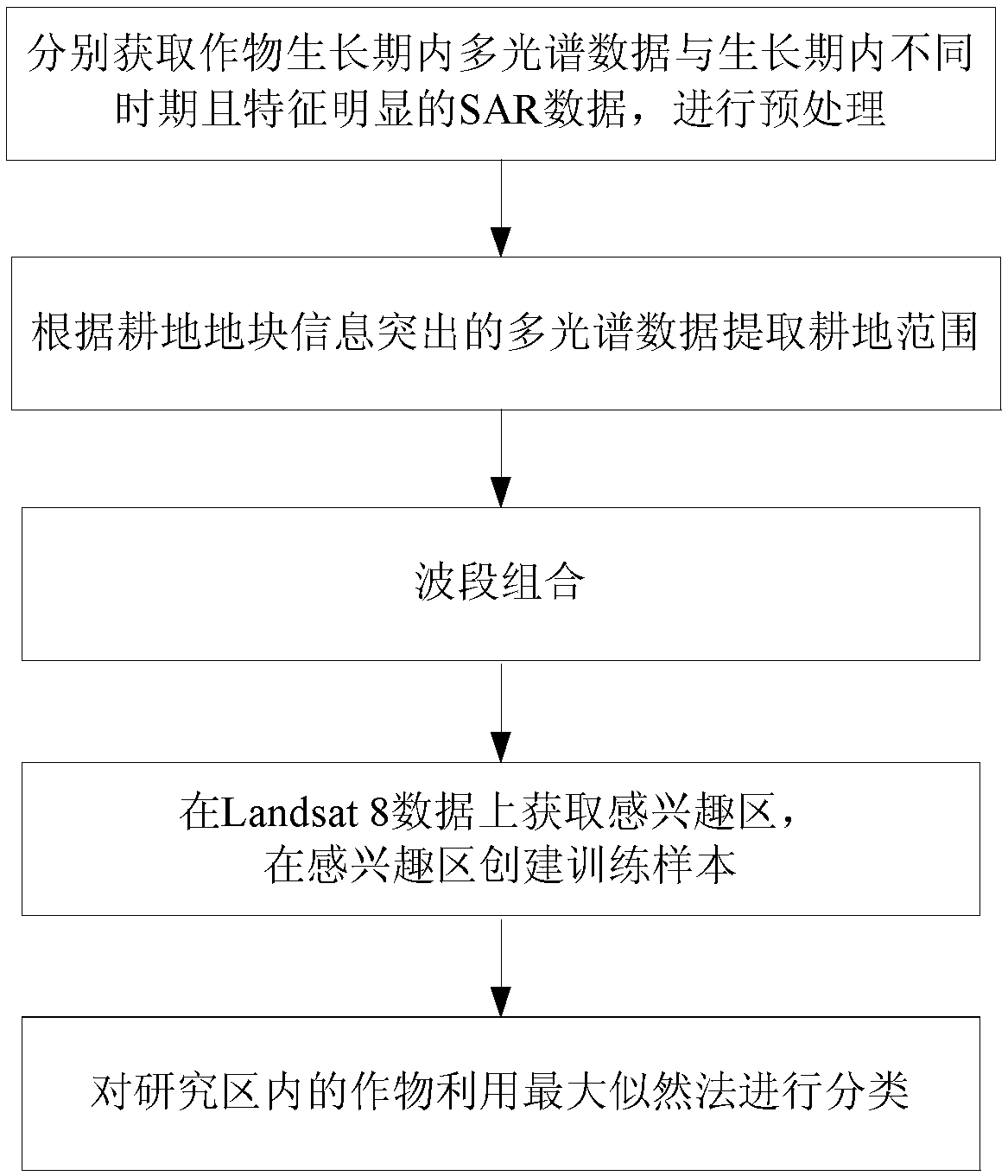
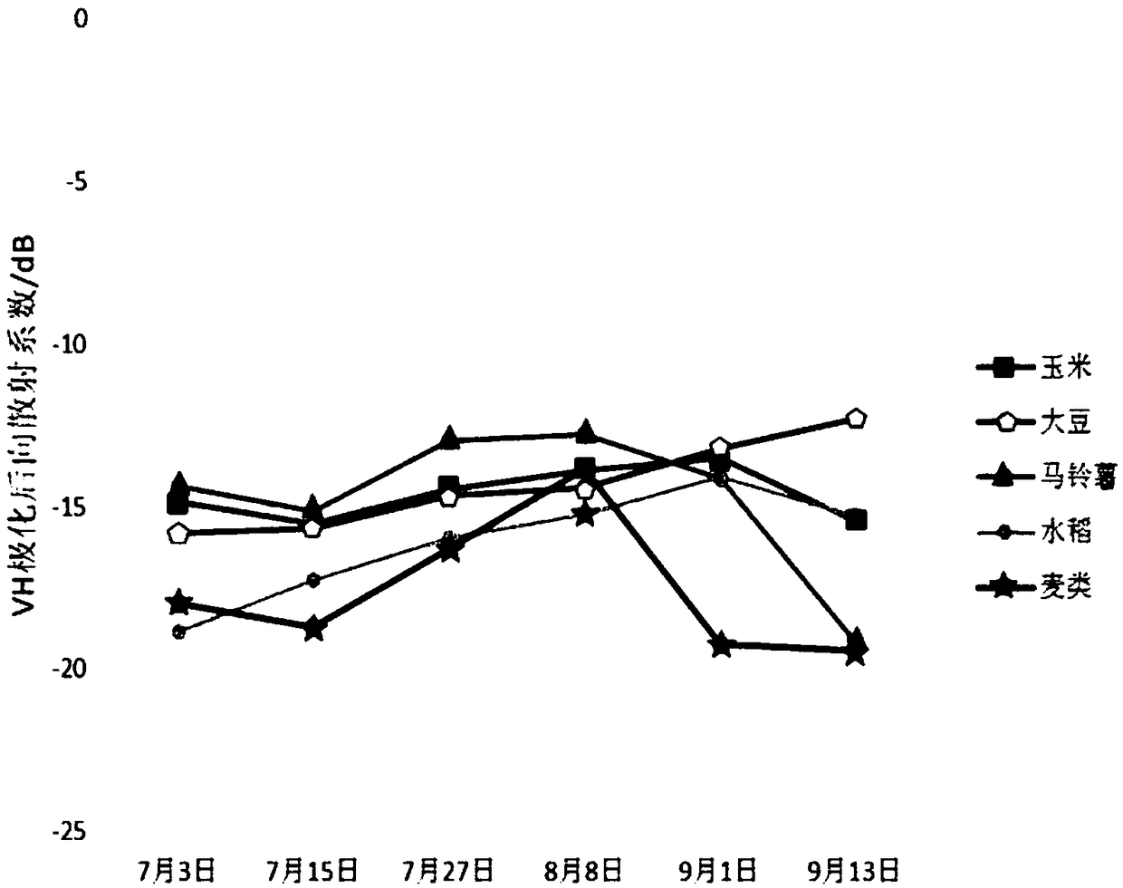
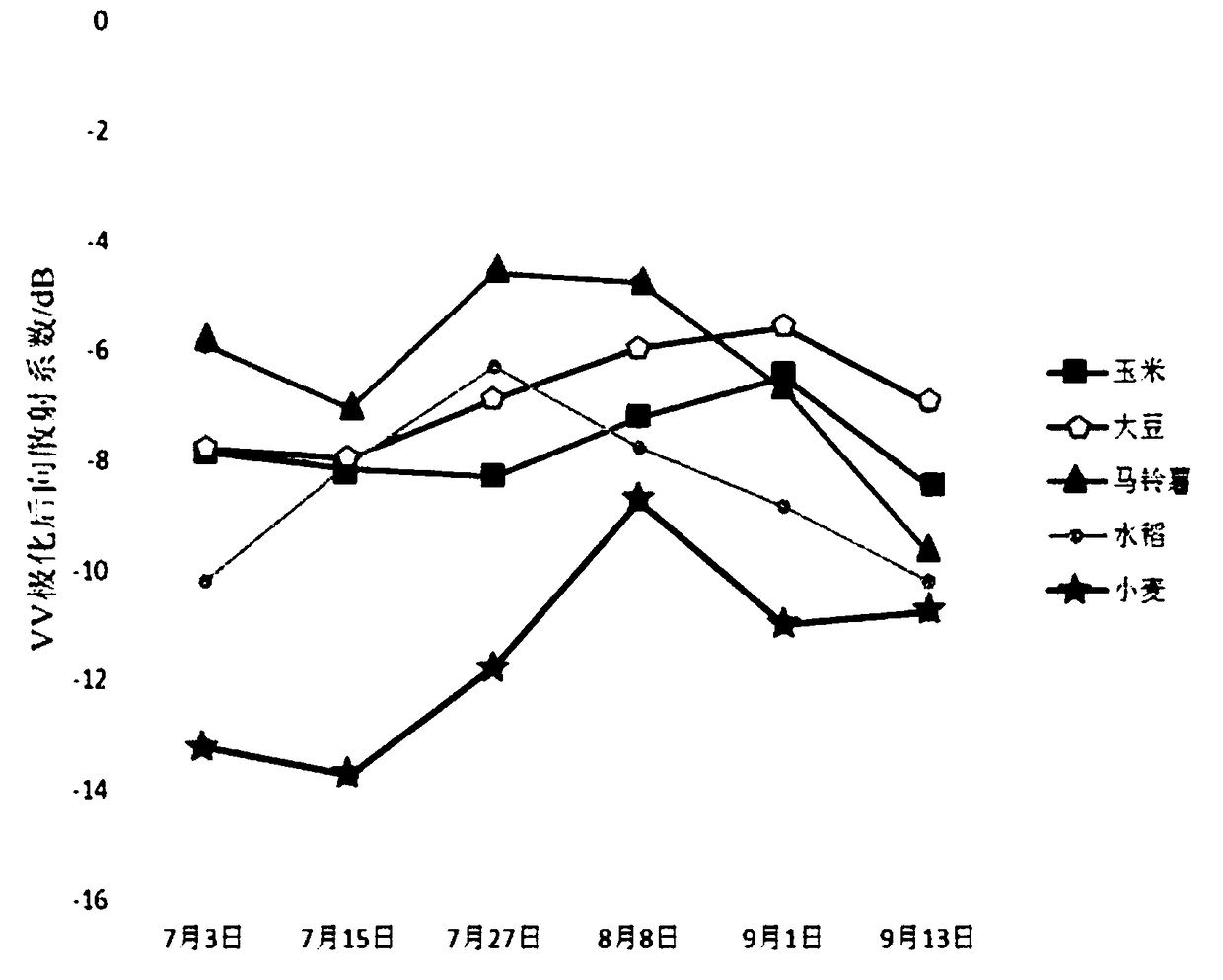
[0055] Step 1: Download the three-phase multispectral data during the crop growth period (GF1: July 9, 2015, September 15, 2015; Landsat8: August 3, 2015), and select according to the image quality; six Phase Sentinel-1A data (July 3, 2015 (wheat milk ripening period), July 15, 2015 (potato tuber growth period), July 27, 2015 (rice heading period), August 8, 2015 (Potato starch precipitation period), September 1, 2015 (crop maturity period), September 13, 2015 (crop maturity period)), and radiometric calibration, atmospheric correction, orthorectification and geometric Preprocessing such as fine correction, format conversion, radiometric calibration, noise filtering, terrain correction, geometric fine correction and other preprocessing for Sentinel-1A images.

[0056] Step 2: Transproject the Sentinel-1A data processed in Step 1, which is consistent with the multispectral data projection, and cut the multispectral and Sentinel-1A data to the same range according to the researc...


PUM


Abstract

In order to solve the problem of low precision of crop remote sensing classification, the invention provides a crop remote sensing classification method based on multi-temporal SAR data and multi-spectral data, belonging to the field of agricultural technology. The invention comprises the following steps: S1, respectively acquiring multi-spectral data in the crop growing period and SAR data with obvious characteristics at different times in the crop growing period; S2, extracting the cultivated land range according to the multi-spectral data with prominent cultivated land information; 3, selecting that VV polarization data band combination of different time in the SAR data to obtain the multi-temporal SAR data, and combining the multi-temporal SAR data with the single-temporal multi-spectral data respectively; 4, creating a training sample; S5, the crops in the study area are classified by maximum likelihood method with the combination of multi-temporal SAR data and single-temporal multi-spectral data bands, multi-temporal SAR data and single-temporal multi-spectral data, which are masked by the extracted cultivated land range, combined with the spectral characteristic mean and covariance of the training samples.

Description

technical field [0001] The invention relates to a method for improving the accuracy of crop remote sensing classification, in particular to a crop remote sensing classification method based on multi-temporal SAR data and multi-spectral data, which belongs to the field of agricultural technology. Background technique [0002] Since the identification and monitoring of crops in the same growth period by multi-spectral data still faces the problem of "same spectrum and foreign objects", and is easily affected by cloudy and rainy weather, it is impossible to obtain available monitoring data during the critical growth period of crops. Based on this situation, radar data has become a usable data source because it can work around the clock and around the clock. And one of the most important contents of remote sensing monitoring of agricultural conditions is the timely and objective forecast of crop planting area and yield. Accurate identification of different crops is a very import...

Claims


Application Information

Patent Timeline
Patent Type & Authority Applications(China)
IPC IPC(8): G06K9/00G06K9/62
CPCG06V20/188G06F18/24
Inventor 刘焕军郭栋孟令华王宗明
Owner NORTHEAST INST OF GEOGRAPHY & AGRIECOLOGY C A S
Learn More