
An Integrated Navigation Integrity Monitoring System for Unmanned Aerial Vehicles

A combined navigation and unmanned aerial vehicle technology, applied in the field of aviation navigation, can solve problems that do not meet the needs of practical applications

Active Publication Date: 2020-12-04
BEIHANG UNIV
View PDF8 Cites 0 Cited by
  • Summary
  • Abstract
  • Description
  • Claims
  • Application Information

AI Technical Summary

Problems solved by technology

To ensure the integrity of the INS system, the traditional method is to use hardware redundancy. However, in the civil field, it is usually necessary to consider the limitation of hardware cost. Therefore, it is obvious that the method of hardware redundancy is used to ensure the integrity of the INS system. Does not meet the actual application requirements

Method used


Image

  • An Integrated Navigation Integrity Monitoring System for Unmanned Aerial Vehicles
  • An Integrated Navigation Integrity Monitoring System for Unmanned Aerial Vehicles
  • An Integrated Navigation Integrity Monitoring System for Unmanned Aerial Vehicles

Examples


Embodiment Construction

[0078] The objects and functions of the present invention and methods for achieving the objects and functions will be clarified by referring to the exemplary embodiments. However, the present invention is not limited to the exemplary embodiments disclosed below; it can be implemented in various forms. The essence of the description is only to help those skilled in the relevant art comprehensively understand the specific details of the present invention.

[0079] Hereinafter, embodiments of the present invention will be described with reference to the accompanying drawings. In the drawings, the same reference numerals represent the same or similar components, or the same or similar steps.

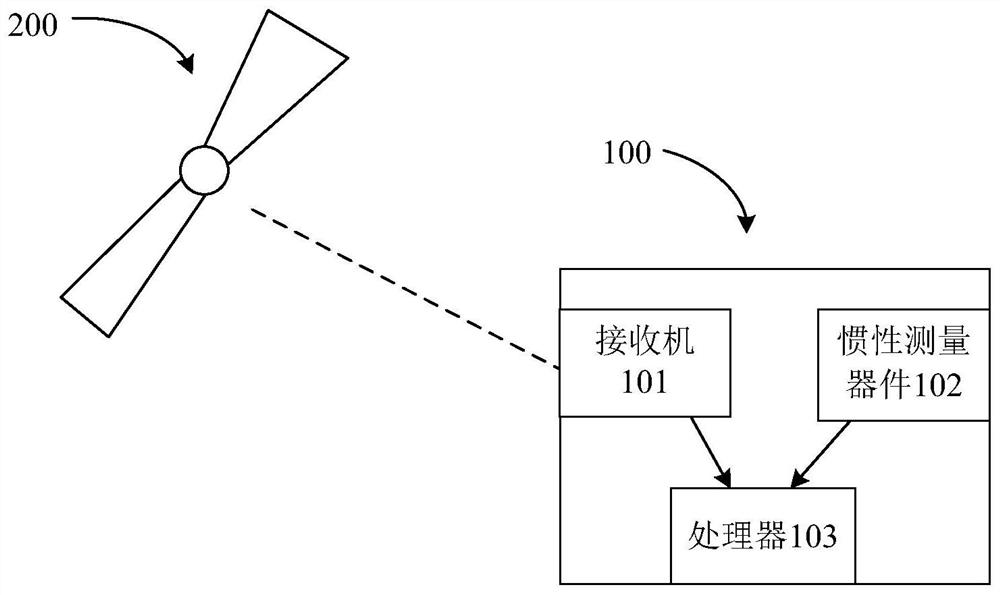
[0080] In order to solve the problem that the integrated navigation of unmanned aerial vehicles in the prior art needs to rely on hardware redundancy to realize the limitation of the integrity of the inertial navigation system, resulting in the high cost of integrated navigation, the presen...


PUM


Abstract

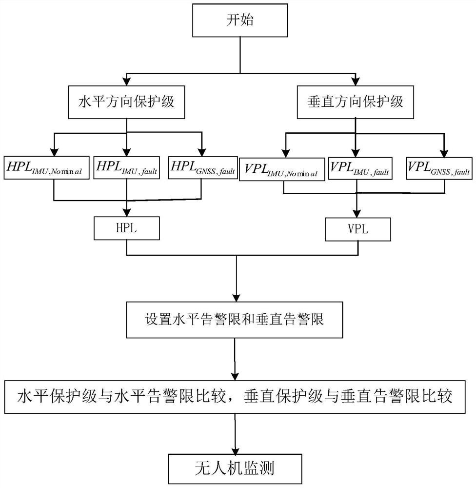
The invention provides an integrated navigation integrity monitoring system for unmanned aerial vehicles, including: an inertial measurement device, used to provide the zero bias value of inertial measurement devices of different levels to the processor; a receiver, used to receive global satellite navigation signal, and provide the integrity risk of the global satellite navigation system to the processor; the processor is used to calculate the horizontal protection level of the integrated navigation and the vertical protection level of the integrated navigation; set the horizontal warning limit and the vertical warning limit, and the calculated The horizontal protection level and the vertical protection level are compared with the corresponding horizontal warning limit and vertical warning limit respectively to monitor the integrity of the UAV. The present invention does not need hardware redundancy to realize the inertial navigation system, which can reduce the integrated navigation integrity monitoring. the cost of.

Description

technical field [0001] The invention relates to the technical field of aviation navigation, in particular to an integrated navigation integrity monitoring system for unmanned aerial vehicles. Background technique [0002] With the application of UAV (Unmanned Aerial Vehicle, UAV) in the civilian field more and more widely, it brings many conveniences to people's work and life, such as agricultural plant protection UAV, aerial photography UAV, etc., but at the same time It has brought many safety hazards, such as the frequent occurrence of "black flying" incidents, flying in crowded places and airports, etc., which have brought many troubles to the production and life of the society. How to effectively realize the safe flight of UAV in the controlled airspace is a practical problem in the current application of UAV in the civilian field. Safety measures to ensure the flight of UAVs in specific areas, to ensure the safety of operations, and to achieve safe and effective fligh...

Claims


Application Information

Patent Timeline
Patent Type & Authority Patents(China)
IPC IPC(8): G01C25/00G01S19/23
CPCG01C21/165G01S19/20G08G5/0069G08G5/006
Inventor 王志鹏朱衍波刘伟
Owner BEIHANG UNIV
Learn More