Winter wheat yield estimation method based on short-period remote sensing area data

A technology of remote sensing data and regional data, applied in the field of remote sensing data analysis

Pending Publication Date: 2019-06-21
ANHUI UNIVERSITY
View PDF6 Cites 11 Cited by
  • Summary
  • Abstract
  • Description
  • Claims
  • Application Information

AI Technical Summary

Problems solved by technology

[0007] The purpose of the present invention is to solve the defect that there is no winter wheat yield prediction based on high temporal and spatial resolution

Method used


Image

  • Winter wheat yield estimation method based on short-period remote sensing area data
  • Winter wheat yield estimation method based on short-period remote sensing area data
  • Winter wheat yield estimation method based on short-period remote sensing area data

Examples


Embodiment Construction

[0067] In order to have a further understanding and understanding of the structural features of the present invention and the achieved effects, the preferred embodiments and accompanying drawings are used for a detailed description, as follows:

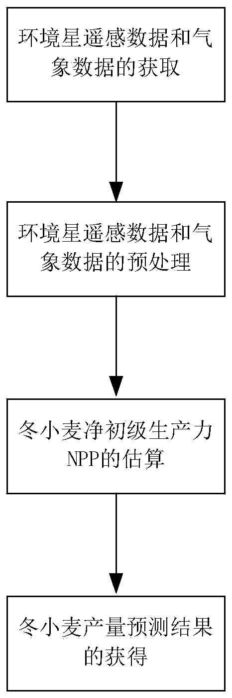
[0068] Such as figure 1 As shown, a kind of winter wheat yield estimation method based on short-period remote sensing regional data of the present invention, comprises the following steps:

[0069] The first step is the acquisition of environmental star remote sensing data and meteorological data. Obtain HJ-1A / B data during the whole growth period, and obtain meteorological data during the whole growth period. The whole growth period of wheat is from October 2008 to June 2009. China's self-developed environment and disaster monitoring and forecasting small satellite constellation A, B star (environmental star) HJ-1A / B is equipped with a CCD sensor with a spatial resolution of 30m; when A star and B star are used in parallel, the retu...


PUM


Abstract

The invention relates to a winter wheat yield estimation method based on short-period remote sensing area data. Compared with the prior art, the winter wheat yield estimation method overcomes the defect that winter wheat yield prediction based on high temporal and spatial resolution NPP data does not exist. The method comprises the following steps: obtaining environmental satellite remote sensingdata and meteorological data; preprocessing the environmental satellite remote sensing data and the meteorological data; estimatingthe net primary productivity NPP of the winter wheat; and obtaining awinter wheat yield prediction result. By utilizing an improved CASA model, high-temporal-spatial-resolution winter wheat NPP spatial distribution information with 5 days as intervals is estimated, and an NPP-yield transformation model is combined so that remote sensing estimation of winter wheat yield is achieved.

Description

technical field [0001] The invention relates to the technical field of remote sensing data analysis, in particular to a method for estimating winter wheat yield based on short-period remote sensing regional data. Background technique [0002] At present, with the rapid development of remote sensing technology, the commonly used production estimation methods have gradually transformed from traditional estimation methods such as time-consuming and labor-intensive statistical investigation methods, agronomic forecasting methods, and agricultural meteorological methods to real-time, wide-coverage, and large-scale data. Large remote sensing estimates. In recent years, many scholars at home and abroad have done a lot of research on crop yield estimation by remote sensing and made some progress. In particular, the method of calculating crop net primary productivity (NPP) based on remote sensing data to simulate crop dry matter, and then estimating crop yield based on crop dry matt...

Claims


Application Information

Patent Timeline
IPC IPC(8): G06Q10/04G06Q50/02
Inventor 黄林生王玉龙徐新刚梁栋徐超黄文江张寒苏胡廷广李泰坤
Owner ANHUI UNIVERSITY
Why Eureka
Try Eureka