Eureka AIR delivers breakthrough ideas for toughest innovation challenges, trusted by R&D personnel around the world.

A multi-tomb pier centripetal structure calculation method based on LiDAR point cloud data

A point cloud data and calculation method technology, applied in the field of multi-tomb piers centripetal structure calculation based on LiDAR point cloud data, can solve problems such as insufficiently rigorous and scientific analysis methods, complex archaeological site environment, etc., to avoid large-scale blind excavation, The effect of improving the level of digital technology

Active Publication Date: 2019-06-28
南京泛在地理信息产业研究院有限公司 +1
View PDF5 Cites 0 Cited by
  • Summary
  • Abstract
  • Description
  • Claims
  • Application Information

AI Technical Summary

Problems solved by technology

This method of analysis is not rigorous and scientific, and has certain limitations.
Coupled with the complex environment of the archaeological site, the irreversibility of archaeology, and the influence of human factors and natural factors, traditional archaeological mapping and analysis methods can no longer fully meet the needs of today's digital archaeology

Method used


Image

  • A multi-tomb pier centripetal structure calculation method based on LiDAR point cloud data
  • A multi-tomb pier centripetal structure calculation method based on LiDAR point cloud data
  • A multi-tomb pier centripetal structure calculation method based on LiDAR point cloud data

Examples


Embodiment Construction

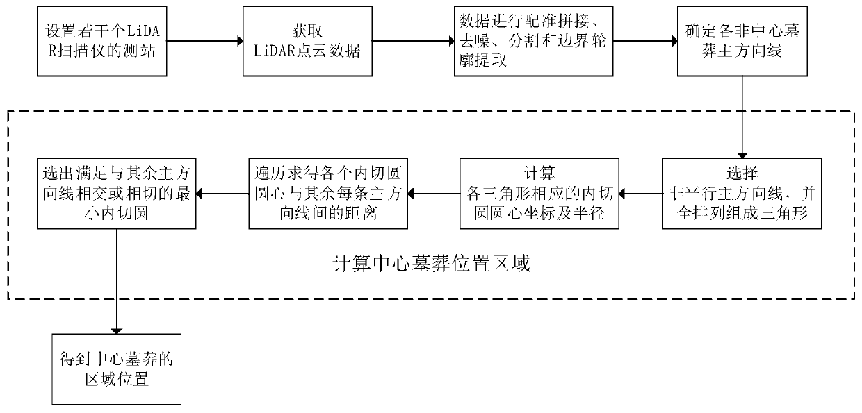
[0026] Since the surrounding tombs with centripetal structures generally present the same direction, and the heads of the tomb owners are generally toward the center, theoretically, the direction lines of all the tombs with centripetal structures should converge at one point. However, due to the process of tomb construction and archaeological excavation It is inevitable that there will be errors in it, so we designed such as figure 1 The calculation method shown to determine the central location area includes the following steps:

[0027] (1) Set up several LiDAR scanner stations according to the spatial layout of multi-tomb piers, so that the LiDAR point cloud data obtained by each station can be spliced ​​to form a complete multi-tomb piers spatial range. Since the point cloud data density of laser scanners is relatively high, it can meet the needs of general archaeological space-time analysis. Therefore, for all scanners with a scanning range of 0° to 360° in the horizontal...


PUM


Abstract

The invention discloses a multi-tomb pier centripetal structure calculation method based on LiDAR point cloud data, and the method comprises the following steps: (1) setting a plurality of observationstations of a LiDAR scanner according to the spatial layout of a multi-tomb pier, and enabling the LiDAR point cloud data obtained by each observation station to be spliced into a complete multi-tombpier spatial range; (2) enabling each observation station to obtain LiDAR point cloud data containing a non-central tomb boundary contour; (3) in an object space coordinate system, allowing LiDAR point cloud data acquired by each observation station to be subjected to registration splicing, denoising, segmentation and boundary contour extraction; (4) according to the processed LiDAR point cloud data, determining the main direction line of each non-central tomb; And (5) calculating the regional position of the central tomb according to all the obtained main direction lines. The multi-tomb piercentripetal structure digital quantitative determination method overcomes the limitation that quantitative and scientific research cannot be carried out on the basis of one-pier multi-tomb with a centripetal structure or manual measurement and manual determination at present, and digital quantitative determination of the multi-tomb pier centripetal structure and automatic calculation of the position of a central tomb area can be realized.

Description

technical field [0001] The invention relates to a calculation method for the centripetal structure of multiple tomb piers, in particular to a calculation method for the centripetal structure of multiple tomb piers based on LiDAR point cloud data. Background technique [0002] Mound tombs are the most important type of tombs in the Zhou Dynasty in the Jiangnan area. There are a huge number of tombs, and "one mound with multiple tombs" with a centripetal structure is a relatively common phenomenon. The so-called centripetal structure means that around the center of the entire mound, multiple tombs are arranged on different levels around it. The direction of each tomb is roughly towards the center of the mound. master-slave relationship. [0003] At present, the centripetality of mound tombs in archaeology is mainly based on the hand-drawn stratum lines and relic outlines by traditional surveying methods, and is judged by visual inspection, with few real data and scientific me...

Claims


Application Information

Patent Timeline
Patent Type & Authority Applications(China)
IPC IPC(8): G06F17/10G06T3/40G06T5/00G06T7/12G06T7/33G06T7/62G06T7/73G01B11/24
CPCY02A90/10
Inventor 杨林沈姜威
Owner 南京泛在地理信息产业研究院有限公司
Why Eureka
Eureka Blog
Learn More