Method and system for estimating orientation angle of steep terrain based on fully polarized SAR

An orientation angle, full polarization technology, applied in radio wave measurement systems, radio wave reflection/re-radiation, instruments, etc., can solve the problem of small orientation angle range, inability to perform large orientation target orientation angles, estimation, etc.

Inactive Publication Date: 2021-05-14
NAT SPACE SCI CENT CAS
View PDF5 Cites 0 Cited by
  • Summary
  • Abstract
  • Description
  • Claims
  • Application Information

AI Technical Summary

Problems solved by technology

[0005] The purpose of the present invention is to overcome the problem that the orientation angle range obtained by the existing orientation angle estimation method is too small due to the uncertainty of the reference axis, and the orientation angle estimation of large orientation targets cannot be performed, thereby providing a steep terrain based on full polarization SAR Method and system for estimating orientation angle to realize accurate estimation of orientation angle in steep terrain

Method used


Image

  • Method and system for estimating orientation angle of steep terrain based on fully polarized SAR
  • Method and system for estimating orientation angle of steep terrain based on fully polarized SAR
  • Method and system for estimating orientation angle of steep terrain based on fully polarized SAR

Examples


Embodiment Construction

[0040] The present invention will be described in detail below in conjunction with the accompanying drawings and specific embodiments.

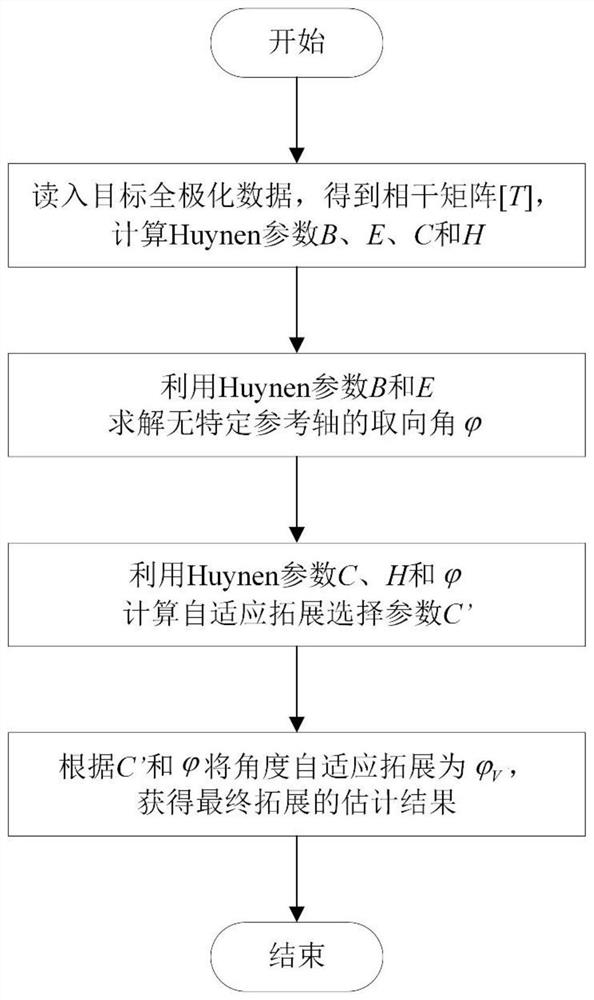
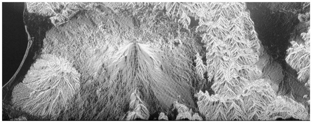
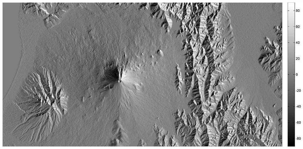
[0041] Such as figure 1 Shown, method of the present invention comprises the following steps:

[0042] Step 1) Obtain the coherence matrix [T] of the target according to the polarization data of the full polarization SAR, and calculate the Huynen parameters B, E, C and H;

[0043] Step 2) According to the Huynen parameters B and E obtained in step 1), solve the orientation angle without a specific reference axis

[0044] Step 3) based on the Huynen parameter C, H that step 1) obtains and step 2) the orientation angle that obtains without specific reference axis Calculate the adaptive expansion selection parameter C';

[0045] Step 4) According to the adaptive expansion selection parameter C' obtained in step 3) and the orientation angle without a specific reference axis obtained in step 2) Orientation angle with no specific reference ...


PUM


Abstract

The present invention relates to a method for estimating the orientation angle of steep terrain based on full-polarization SAR, comprising: calculating the orientation angle of the steep terrain without a definite reference axis according to the full-polarization synthetic aperture radar data, determining the adaptive expansion selection parameter, and converting the The orientation angle of the above-mentioned undetermined reference axis is extended to the angle between the vertical polarization axis v, so as to obtain the correct estimation value of the orientation angle of the steep terrain. The present invention also proposes a steep terrain orientation angle estimation system based on full polarization synthetic aperture radar, including a coherence matrix acquisition module, a parameter calculation module, an orientation angle calculation module without a specific reference axis, an adaptive expansion selection parameter calculation module and Orientation angle estimation module for steep terrain. Calculate the compressed polarization orientation angle when the target has no definite reference axis according to the full polarization synthetic aperture radar data, determine the reference axis of the orientation angle and expand it, effectively expand the estimation range of the orientation angle, and realize accurate estimation of steepness The purpose of terrain orientation angles.

Description

technical field [0001] The invention relates to the field of polarization orientation angle estimation of full-polarization synthetic aperture radar targets, in particular to a method and system for estimating steep terrain orientation angles based on full-polarization SAR, and is especially suitable for steep terrain targets. Background technique [0002] Full-polarization synthetic aperture radar (Synthetic Aperture Radar for short SAR) can obtain the full-polarization scattering information of the target. Compared with single-polarization synthetic aperture radar, it can describe the state and nature of the target more comprehensively. In recent years, it has been widely used in target detection and recognition, object classification, surface parameter inversion, etc. The target orientation angle refers to the angle of rotation of the target around the radar line of sight, which can be estimated from the full polarization synthetic aperture radar data. For example, liter...

Claims


Application Information

Patent Timeline
Patent Type & Authority Patents(China)
IPC IPC(8): G01S13/90
Inventor 梁莉婷张云华李东
Owner NAT SPACE SCI CENT CAS
Why Eureka
Try Eureka